
| Birth | : | 22 Mar 1927 Hawarden, Sioux County, Iowa, USA |
| Death | : | 25 Dec 1995 Des Moines, Polk County, Iowa, USA |
| Burial | : | Riverside Cemetery, Akron, Plymouth County, USA |
| Coordinate | : | 42.8367004, -96.5453033 |
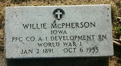
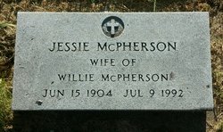
| Description | : | From obituary - daughter of Willie and Jessie (Jager) McPherson. |
frequently asked questions (FAQ):
-
Where is Dorothy Ellen McPherson Harvey's memorial?
Dorothy Ellen McPherson Harvey's memorial is located at: Riverside Cemetery, Akron, Plymouth County, USA.
-
When did Dorothy Ellen McPherson Harvey death?
Dorothy Ellen McPherson Harvey death on 25 Dec 1995 in Des Moines, Polk County, Iowa, USA
-
Where are the coordinates of the Dorothy Ellen McPherson Harvey's memorial?
Latitude: 42.8367004
Longitude: -96.5453033
Family Members:
Parent
Spouse

Siblings
Flowers:


Nearby Cemetories:
1. Riverside Cemetery
Akron, Plymouth County, USA
Coordinate: 42.8367004, -96.5453033
2. Saint Patricks Cemetery
Akron, Plymouth County, USA
Coordinate: 42.8232300, -96.5374800
3. Mount Hope Cemetery
Union County, USA
Coordinate: 42.8885994, -96.5667038
4. Union Creek Cemetery
Union County, USA
Coordinate: 42.8911018, -96.5863037
5. Gores Bluff Cemetery
Union County, USA
Coordinate: 42.8035069, -96.6260468
6. Westfield Township Cemetery
Westfield, Plymouth County, USA
Coordinate: 42.7510986, -96.5914001
7. Richland Cemetery
Richland, Union County, USA
Coordinate: 42.7682991, -96.6624985
8. Pleasant Hill Cemetery
Spink, Union County, USA
Coordinate: 42.8741000, -96.6876000
9. Big Springs Cemetery
Big Springs, Union County, USA
Coordinate: 42.9379000, -96.6090000
10. Old Big Springs Cemetery
Big Springs, Union County, USA
Coordinate: 42.9455986, -96.5868988
11. Saint Johns Lutheran Church Cemetery
Ruble, Plymouth County, USA
Coordinate: 42.8372000, -96.3799000
12. Mills Family Cemetery
Westfield, Plymouth County, USA
Coordinate: 42.7188460, -96.6019280
13. First Brule Creek Cemetery
Elk Point, Union County, USA
Coordinate: 42.7943993, -96.7069016
14. Pleasant Hill Cemetery Old
Spink, Union County, USA
Coordinate: 42.8588462, -96.7215592
15. Brule Creek Cemetery
Spink Township, Union County, USA
Coordinate: 42.8346510, -96.7324350
16. Pleasant Valley Cemetery
Adaville, Plymouth County, USA
Coordinate: 42.7494011, -96.4005966
17. Saint Paul Cemetery
Elk Point, Union County, USA
Coordinate: 42.7641983, -96.7061005
18. Union County Poor Farm Cemetery
Union County, USA
Coordinate: 42.7649210, -96.7077580
19. Nora Cemetery
Union County, USA
Coordinate: 42.9314003, -96.7061005
20. Plymouth Presbyterian Cemetery
Brunsville, Plymouth County, USA
Coordinate: 42.8208760, -96.3318410
21. Ahlsborg Lutheran Cemetery
Union County, USA
Coordinate: 42.8228000, -96.7612000
22. Saint Joseph Cemetery
Johnson Township, Plymouth County, USA
Coordinate: 42.7416992, -96.3707962
23. Peace Lutheran Cemetery
Union County, USA
Coordinate: 42.9805984, -96.6481018
24. Saint Johns Cemetery
Craig, Plymouth County, USA
Coordinate: 42.8939018, -96.3225021