

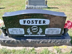
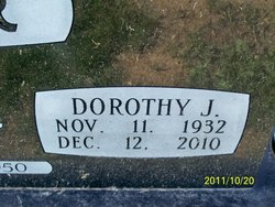
Dorothy Jean Schenewerk Foster
| Birth | : | 11 Nov 1932 California, Moniteau County, Missouri, USA |
| Death | : | 12 Dec 2010 Springfield, Greene County, Missouri, USA |
| Burial | : | Mohr Cemetery, Van Wert, Van Wert County, USA |
| Coordinate | : | 40.9519005, -84.5614014 |
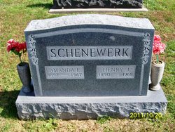
| Description | : | Dorothy Jean Foster, age 78, formerly of Tipton and California, Mo. passed away Sunday, December 12, 2010 at the Neighborhoods at Quail Creek Nursing Home in Springfield, Mo. She was born November 11, 1932 in California, Mo. the daughter of Henry J. and Amanda Lee Allee Schenewerk, both of whom preceded her in death. Dorothy was united in marriage May 20, 1950, in California, Mo. to James Foster, who also preceded her in death in 1995. Dorothy retired after many years of service as bookkeeper for Co-Mo Electric. After retirement she spent several years working at Cals 2, where she... Read More |
frequently asked questions (FAQ):
-
Where is Dorothy Jean Schenewerk Foster's memorial?
Dorothy Jean Schenewerk Foster's memorial is located at: Mohr Cemetery, Van Wert, Van Wert County, USA.
-
When did Dorothy Jean Schenewerk Foster death?
Dorothy Jean Schenewerk Foster death on 12 Dec 2010 in Springfield, Greene County, Missouri, USA
-
Where are the coordinates of the Dorothy Jean Schenewerk Foster's memorial?
Latitude: 40.9519005
Longitude: -84.5614014
Family Members:
Parent

Spouse

Siblings

Flowers:


Nearby Cemetories:
1. Mohr Cemetery
Van Wert, Van Wert County, USA
Coordinate: 40.9519005, -84.5614014
2. McClure-Dowler Cemetery
Van Wert County, USA
Coordinate: 40.9421997, -84.5746994
3. Taylor Cemetery
Van Wert County, USA
Coordinate: 40.9421997, -84.5746994
4. Scott Cemetery
Scott, Van Wert County, USA
Coordinate: 40.9892006, -84.5950012
5. Dunkard Cemetery
Hoaglin, Van Wert County, USA
Coordinate: 40.9463997, -84.5006027
6. Mount Pleasant Cemetery
Van Wert County, USA
Coordinate: 40.9516983, -84.4961014
7. Van Wert Mausoleum (Defunct)
Van Wert, Van Wert County, USA
Coordinate: 40.8698690, -84.6138640
8. Woodland Union Cemetery
Van Wert, Van Wert County, USA
Coordinate: 40.8675003, -84.6156006
9. Dix Cemetery
Van Wert County, USA
Coordinate: 40.8852997, -84.6492004
10. Blue Creek Cemetery
Haviland, Paulding County, USA
Coordinate: 41.0385200, -84.6116100
11. Middle Creek Cemetery
Grover Hill, Paulding County, USA
Coordinate: 41.0050011, -84.4509964
12. Abbott Cemetery
Latty, Paulding County, USA
Coordinate: 41.0480090, -84.5966750
13. Ridge Cemetery
Middle Point, Van Wert County, USA
Coordinate: 40.8781013, -84.4692001
14. Sugar Ridge Cemetery
Convoy, Van Wert County, USA
Coordinate: 40.9382858, -84.6982346
15. IOOF Cemetery
Convoy, Van Wert County, USA
Coordinate: 40.9306330, -84.6990970
16. Pleasant View Cemetery
Paulding, Paulding County, USA
Coordinate: 41.0611000, -84.5699997
17. Dague Cemetery
Latty, Paulding County, USA
Coordinate: 41.0628260, -84.5802310
18. Apostolic Christian Church Cemetery
Latty, Paulding County, USA
Coordinate: 41.0760002, -84.5749969
19. King Cemetery
Middle Point, Van Wert County, USA
Coordinate: 40.8664017, -84.4377975
20. Mount Zion Cemetery
Latty, Paulding County, USA
Coordinate: 41.0536003, -84.4582977
21. Dotson Cemetery
Monterey Township, Putnam County, USA
Coordinate: 40.9841995, -84.3946991
22. Dealey Cemetery
Payne, Paulding County, USA
Coordinate: 41.0038986, -84.7221985
23. Saint Johns Cemetery
Van Wert County, USA
Coordinate: 40.8880997, -84.7174988
24. Middle Creek Zion Baptist Church Cemetery
Roselms, Paulding County, USA
Coordinate: 41.0340004, -84.4179993