

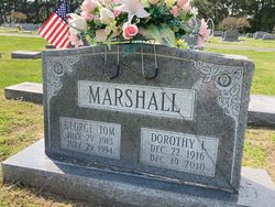

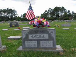
Dorothy Lee “Dot” Riggin Marshall
| Birth | : | 22 Dec 1916 Crisfield, Somerset County, Maryland, USA |
| Death | : | 19 Dec 2010 Crisfield, Somerset County, Maryland, USA |
| Burial | : | New Cliff Cemetery, Cannelton, Perry County, USA |
| Coordinate | : | 37.9131760, -86.7359460 |
| Description | : | DOROTHY LEE "Dot" MARSHALL, of Crisfield, died Sunday, December 19, 2010 at McCready Memorial Hospital in Crisfield. She would have been 94 on Wednesday. Born in Crisfield on December 22, 1916, she was a daughter of the late Clarence "Putty" and Mildred Ward Riggin. Her husband, George Thomas Marshall, Jr., preceded her in death July 29, 1994. She was retired from Rubberset Corp in Crisfield. She was a member of Asbury United Methodist Church in Crisfield where she was active in the UMW and the Debra Circle. She also loved to cook and travel. She enjoyed trips with the AARP... Read More |
frequently asked questions (FAQ):
-
Where is Dorothy Lee “Dot” Riggin Marshall's memorial?
Dorothy Lee “Dot” Riggin Marshall's memorial is located at: New Cliff Cemetery, Cannelton, Perry County, USA.
-
When did Dorothy Lee “Dot” Riggin Marshall death?
Dorothy Lee “Dot” Riggin Marshall death on 19 Dec 2010 in Crisfield, Somerset County, Maryland, USA
-
Where are the coordinates of the Dorothy Lee “Dot” Riggin Marshall's memorial?
Latitude: 37.9131760
Longitude: -86.7359460
Family Members:
Spouse
Flowers:


Nearby Cemetories:
1. New Cliff Cemetery
Cannelton, Perry County, USA
Coordinate: 37.9131760, -86.7359460
2. Cliff Cemetery
Cannelton, Perry County, USA
Coordinate: 37.9122270, -86.7352520
3. Saint Michaels Cemetery
Cannelton, Perry County, USA
Coordinate: 37.9164009, -86.7332993
4. First Cannelton Cemetery
Cannelton, Perry County, USA
Coordinate: 37.9099030, -86.7417420
5. Fournier Cemetery
Cannelton, Perry County, USA
Coordinate: 37.9118570, -86.7272720
6. Walnut Grove Cemetery
Tell City, Perry County, USA
Coordinate: 37.9275720, -86.7412670
7. Hawesville Cemetery
Hawesville, Hancock County, USA
Coordinate: 37.8982100, -86.7546200
8. Cavender Cemetery
Cannelton, Perry County, USA
Coordinate: 37.8978090, -86.7146910
9. Saint Paul Cemetery
Hawesville, Hancock County, USA
Coordinate: 37.8969780, -86.7592740
10. Ayres Cemetery
Hawesville, Hancock County, USA
Coordinate: 37.9015700, -86.7778000
11. Bolin Cemetery
Cannelton, Perry County, USA
Coordinate: 37.9384820, -86.7049380
12. Mount Calvary Cemetery
Hawesville, Hancock County, USA
Coordinate: 37.9001300, -86.7774300
13. Chestnut Grove Cemetery
Tell City, Perry County, USA
Coordinate: 37.9475250, -86.7246094
14. Serenity Hills Cemetery
Hawesville, Hancock County, USA
Coordinate: 37.9007600, -86.7781890
15. Mosby Cemetery
Tell City, Perry County, USA
Coordinate: 37.9597630, -86.7572160
16. Thresher Cemetery
Troy Township, Perry County, USA
Coordinate: 37.9567440, -86.7036900
17. Mason Cemetery
Cannelton, Perry County, USA
Coordinate: 37.9168130, -86.6696620
18. Greenwood Cemetery
Tell City, Perry County, USA
Coordinate: 37.9644012, -86.7506027
19. Buxton Cemetery
Hancock County, USA
Coordinate: 37.9021850, -86.8021020
20. Beauchamp Family Cemetery #8
Lewisport, Hancock County, USA
Coordinate: 37.9242760, -86.8043390
21. Powell Cemetery
Tell City, Perry County, USA
Coordinate: 37.9678460, -86.7269160
22. Saint Marys Catholic Cemetery
Tell City, Perry County, USA
Coordinate: 37.9664307, -86.7682190
23. Fairview Cemetery
Hancock County, USA
Coordinate: 37.8885994, -86.6669006
24. Sterrett Cemetery
Hancock County, USA
Coordinate: 37.8878070, -86.6601460