Dorothy M. Yager Jannotta
| Birth | : | 7 Feb 1912 Ione, Amador County, California, USA |
| Death | : | 5 Sep 2002 San Mateo, San Mateo County, California, USA |
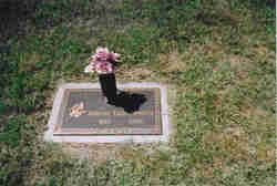
| Burial | : | Ramble Creek Cemetery, Big Sandy, Benton County, USA |
| Coordinate | : | 36.2036000, -88.0784750 |
| Plot | : | Section C Row 4 Plot 9 |
| Description | : | JANNOTTA DOROTHY M. YAGER Died in San Mateo, CA on Thursday, September 5, 2002, at the age of 90 years. Her brother, Stanley Yager of Ione, CA and many cousins survive her. At her request a private service was held. Interment was in the Ione Public Cemetery, Ione, CA. Memorial contributions can be made to the charity of your choice. Arrangements by: DANERI MORTUARY JACKSON, CA (209) 223-0793. Alameda Times-Star 9/11/02. |
frequently asked questions (FAQ):
-
Where is Dorothy M. Yager Jannotta's memorial?
Dorothy M. Yager Jannotta's memorial is located at: Ramble Creek Cemetery, Big Sandy, Benton County, USA.
-
When did Dorothy M. Yager Jannotta death?
Dorothy M. Yager Jannotta death on 5 Sep 2002 in San Mateo, San Mateo County, California, USA
-
Where are the coordinates of the Dorothy M. Yager Jannotta's memorial?
Latitude: 36.2036000
Longitude: -88.0784750
Family Members:
Parent
Spouse
Siblings
Flowers:
Nearby Cemetories:
1. Ramble Creek Cemetery
Big Sandy, Benton County, USA
Coordinate: 36.2036000, -88.0784750
2. McRaes Chapel Cemetery
Big Sandy, Benton County, USA
Coordinate: 36.2187940, -88.0747570
3. Margaret McKenzie Brewer Cemetery
Big Sandy, Benton County, USA
Coordinate: 36.2028000, -88.0543000
4. Richardson Cemetery
Big Sandy, Benton County, USA
Coordinate: 36.2346220, -88.0680200
5. Edward Lindsey Cemetery
Big Sandy, Benton County, USA
Coordinate: 36.2401740, -88.0707360
6. Bakers Chapel Cemetery
Big Sandy, Benton County, USA
Coordinate: 36.1772003, -88.1164017
7. Willow Cemetery
Big Sandy, Benton County, USA
Coordinate: 36.2548020, -88.0759660
8. Craig - Farmer Family Cemetery
Henry County, USA
Coordinate: 36.2350006, -88.1292038
9. Mount Zion Cemetery
Benton County, USA
Coordinate: 36.1782840, -88.0200180
10. Cedar Grove Church of Christ Cemetery
Big Sandy, Benton County, USA
Coordinate: 36.1555280, -88.0420920
11. Moore Cemetery
Big Sandy, Benton County, USA
Coordinate: 36.1473000, -88.0852000
12. Lowry Cemetery
Henry County, USA
Coordinate: 36.2132988, -88.1519012
13. Pleasant Ridge Cemetery
Big Sandy, Benton County, USA
Coordinate: 36.2630390, -88.0556540
14. Beaton Cemetery
Benton County, USA
Coordinate: 36.2677994, -88.0777969
15. Rushings Creek Cemetery
Camden, Benton County, USA
Coordinate: 36.1431340, -88.1096870
16. Dennis Rushing Cemetery
Big Sandy, Benton County, USA
Coordinate: 36.1391640, -88.0967380
17. Weatherly Cemetery
Benton County, USA
Coordinate: 36.1455994, -88.1222000
18. Hudson-Willis Rushing Cemetery
Big Sandy, Benton County, USA
Coordinate: 36.1342690, -88.0903790
19. Mount Vinson Cemetery
Big Sandy, Benton County, USA
Coordinate: 36.2732060, -88.0686740
20. Berry Cemetery
Big Sandy, Benton County, USA
Coordinate: 36.1506004, -88.0207977
21. Roney Cemetery
Big Sandy, Benton County, USA
Coordinate: 36.2762160, -88.0668460
22. Williams Grove Cemetery
Camden, Benton County, USA
Coordinate: 36.1516660, -88.1450530
23. Manleyville Cemetery
Manleyville, Henry County, USA
Coordinate: 36.2268982, -88.1669006
24. Wheatley Cemetery
Benton County, USA
Coordinate: 36.1864014, -87.9878006


