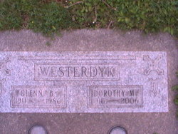
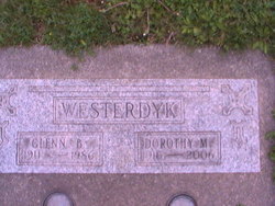
Dorothy Muller Westerdyk
| Birth | : | 27 Aug 1916 Island County, Washington, USA |
| Death | : | 18 Oct 2006 Island County, Washington, USA |
| Burial | : | Copp's Hill Burying Ground, Boston, Suffolk County, USA |
| Coordinate | : | 42.3670100, -71.0560800 |
| Plot | : | Sec 2, blk 45, lot 4 |
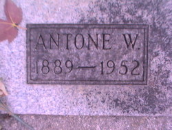
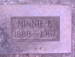
| Description | : | Following a brief illness, Dorothy Muller Westerdyk died at the family home in Crescent Harbor on Oct. 18, 2006, with her family at her bedside. At Dorothy's request, no services will be held. Dorothy was born Aug. 27, 1916 to Antone W. and Minnie B. Muller at the family farm in Crescent Harbor in the home still owned by her son Antone. She attended Crescent Harbor Grade School and graduated from Oak Harbor High School in 1934. Dorothy briefly attended business college in Seattle. On June 18, 1938, she married Glenn B. Westerdyk. From that union, a son Antone (Tony)... Read More |
frequently asked questions (FAQ):
-
Where is Dorothy Muller Westerdyk's memorial?
Dorothy Muller Westerdyk's memorial is located at: Copp's Hill Burying Ground, Boston, Suffolk County, USA.
-
When did Dorothy Muller Westerdyk death?
Dorothy Muller Westerdyk death on 18 Oct 2006 in Island County, Washington, USA
-
Where are the coordinates of the Dorothy Muller Westerdyk's memorial?
Latitude: 42.3670100
Longitude: -71.0560800
Family Members:
Parent
Spouse
Siblings
Children
Flowers:
Nearby Cemetories:
1. Copp's Hill Burying Ground
Boston, Suffolk County, USA
Coordinate: 42.3670100, -71.0560800
2. Christ Church Cemetery
Boston, Suffolk County, USA
Coordinate: 42.3664900, -71.0545200
3. Charlestown Revolutionary War Memorial
Charlestown, Suffolk County, USA
Coordinate: 42.3745800, -71.0601800
4. Kings Chapel Burying Ground
Boston, Suffolk County, USA
Coordinate: 42.3583340, -71.0600370
5. Bunker Hill Monument
Charlestown, Suffolk County, USA
Coordinate: 42.3762360, -71.0607300
6. Granary Burying Ground
Boston, Suffolk County, USA
Coordinate: 42.3572400, -71.0613500
7. Trinity Church Tombs (Defunct)
Boston, Suffolk County, USA
Coordinate: 42.3549300, -71.0597500
8. Phipps Street Burying Ground
Charlestown, Suffolk County, USA
Coordinate: 42.3766300, -71.0673000
9. Bunker Hill Burying Ground
Charlestown, Suffolk County, USA
Coordinate: 42.3789300, -71.0621200
10. Central Burying Ground
Boston, Suffolk County, USA
Coordinate: 42.3526300, -71.0659500
11. Saint Francis de Sales Cemetery
Charlestown, Suffolk County, USA
Coordinate: 42.3815420, -71.0658620
12. Cocoanut Grove Fire Memorial
Boston, Suffolk County, USA
Coordinate: 42.3499600, -71.0681900
13. Old South Church
Boston, Suffolk County, USA
Coordinate: 42.3500500, -71.0779000
14. Cathedral of the Holy Cross Crypt
Boston, Suffolk County, USA
Coordinate: 42.3408200, -71.0697400
15. Garden Cemetery
Chelsea, Suffolk County, USA
Coordinate: 42.3905983, -71.0330963
16. Saint Matthews Cemetery (Defunct)
South Boston, Suffolk County, USA
Coordinate: 42.3379940, -71.0497180
17. Bennington Street Cemetery
East Boston, Suffolk County, USA
Coordinate: 42.3814300, -71.0213000
18. South Burying Ground
Boston, Suffolk County, USA
Coordinate: 42.3382600, -71.0741000
19. South Boston Farm Cemetery (Defunct)
South Boston, Suffolk County, USA
Coordinate: 42.3388510, -71.0326710
20. Saint Augustine Cemetery
South Boston, Suffolk County, USA
Coordinate: 42.3339900, -71.0491800
21. Temple Ohabei Shalom Cemetery
East Boston, Suffolk County, USA
Coordinate: 42.3827900, -71.0145700
22. Hawes Burying Ground
South Boston, Suffolk County, USA
Coordinate: 42.3340607, -71.0345078
23. Union Cemetery
South Boston, Suffolk County, USA
Coordinate: 42.3340440, -71.0344730
24. Milk Row Cemetery
Somerville, Middlesex County, USA
Coordinate: 42.3816300, -71.1020100

