
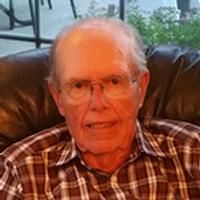
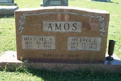
Dorsey D. Amos
| Birth | : | 25 Feb 1934 Enon, Moniteau County, Missouri, USA |
| Death | : | 17 Jul 2016 Jefferson City, Cole County, Missouri, USA |
| Burial | : | Enloe Cemetery, Moniteau County, USA |
| Coordinate | : | 38.5074997, -92.4741974 |
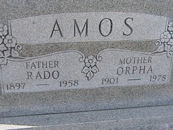
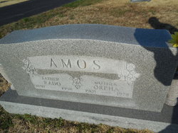
| Description | : | Dorsey D. Amos, age 82, of Jefferson City, formerly of Russellville, went to be with his Lord Sunday morning, July 17, 2016, at his home. He was born February 25, 1934, on the family farm in Enon, a son of Rado and Orpha Ellen Scott Amos. On October 8, 1954, at the Enon Baptist Church, Dorsey was united in marriage to Marilyn J. Reichel, who survives at their home. He was a 1951 graduate of Russellville High School. As a young man, Dorsey went to work at the Russellville MFA. He was later employed in the Workman’s Comp... Read More |
frequently asked questions (FAQ):
-
Where is Dorsey D. Amos's memorial?
Dorsey D. Amos's memorial is located at: Enloe Cemetery, Moniteau County, USA.
-
When did Dorsey D. Amos death?
Dorsey D. Amos death on 17 Jul 2016 in Jefferson City, Cole County, Missouri, USA
-
Where are the coordinates of the Dorsey D. Amos's memorial?
Latitude: 38.5074997
Longitude: -92.4741974
Family Members:
Parent
Spouse
Siblings
Flowers:


Nearby Cemetories:
1. Enloe Cemetery
Moniteau County, USA
Coordinate: 38.5074997, -92.4741974
2. Belleville Cemetery
Russellville, Cole County, USA
Coordinate: 38.4970490, -92.4667150
3. Enon Cemetery
Russellville, Cole County, USA
Coordinate: 38.4888992, -92.4730988
4. Karnes-Carney-Henderson Cemetery
Burris Fork, Moniteau County, USA
Coordinate: 38.4992100, -92.5007510
5. Saint Michael Cemetery
Russellville, Cole County, USA
Coordinate: 38.5109300, -92.4429100
6. Evangelical Lutheran Cemetery One Acre
Russellville, Cole County, USA
Coordinate: 38.5175667, -92.4415817
7. Buckner Russell Cemetery
Cole County, USA
Coordinate: 38.5136900, -92.4359390
8. Van Pool Cemetery
Moniteau County, USA
Coordinate: 38.5372009, -92.4627991
9. Russellville Cemetery
Russellville, Cole County, USA
Coordinate: 38.5196991, -92.4366989
10. Trinity Lutheran Cemetery
Russellville, Cole County, USA
Coordinate: 38.5028000, -92.4317017
11. Karnes Cemetery
Corticelli, Moniteau County, USA
Coordinate: 38.5099700, -92.5247900
12. Campbell Cemetery
Cole County, USA
Coordinate: 38.4810982, -92.4297028
13. Blank Cemetery
Russellville, Cole County, USA
Coordinate: 38.5203018, -92.4180984
14. DeFoe Cemetery
California, Moniteau County, USA
Coordinate: 38.5416985, -92.5250015
15. Rock Enon Cemetery
Miller County, USA
Coordinate: 38.4668400, -92.5170700
16. Bruce-Lewis-McGahan Cemetery
Enon, Moniteau County, USA
Coordinate: 38.4667500, -92.5172100
17. Roark Cemetery
Russellville, Cole County, USA
Coordinate: 38.4696999, -92.4255981
18. Matheis Cemetery
Russellville, Cole County, USA
Coordinate: 38.4571800, -92.4491600
19. Barnhardt Cemetery
Lohman, Cole County, USA
Coordinate: 38.5537900, -92.4267100
20. Clibourn Cemetery
Russellville, Cole County, USA
Coordinate: 38.4760500, -92.3973500
21. Marney Family Cemetery
High Point, Moniteau County, USA
Coordinate: 38.5357900, -92.5614500
22. Jackson Chapel Methodist Church Cemetery
California, Moniteau County, USA
Coordinate: 38.4447900, -92.5286500
23. Yarnell Cemetery
California, Moniteau County, USA
Coordinate: 38.5189018, -92.5708008
24. Gray Cemetery
Moniteau County, USA
Coordinate: 38.4536018, -92.5456009