
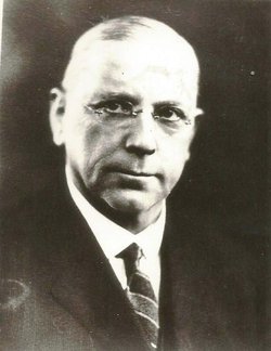
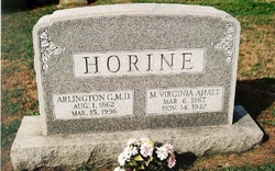

Dr Arlington Grove Horine
| Birth | : | 1 Aug 1862 Petersville, Frederick County, Maryland, USA |
| Death | : | 15 Mar 1956 Frederick, Frederick County, Maryland, USA |
| Burial | : | Walpole St Andrew, Walpole, Kings Lynn and West Norfolk Borough, England |
| Coordinate | : | 52.7349520, 0.2227630 |
| Plot | : | Section 3, Row 7, Grouping 15 |
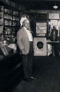
| Description | : | Owner and operator of Horine's Drug Store and Soda Fountain Shop in Brunswick, MD. Until his passing, the friendly Dr. Horine could be found most days behind the counter serving ice cream to children of all ages. Dr. Horine was a surgeon with the Baltimore and Ohio Railroad from 1891-1903 and Brunswick's mayor from 1906 thru 1914. |
frequently asked questions (FAQ):
-
Where is Dr Arlington Grove Horine's memorial?
Dr Arlington Grove Horine's memorial is located at: Walpole St Andrew, Walpole, Kings Lynn and West Norfolk Borough, England.
-
When did Dr Arlington Grove Horine death?
Dr Arlington Grove Horine death on 15 Mar 1956 in Frederick, Frederick County, Maryland, USA
-
Where are the coordinates of the Dr Arlington Grove Horine's memorial?
Latitude: 52.7349520
Longitude: 0.2227630
Family Members:
Parent
Spouse

Siblings
Children


Nearby Cemetories:
1. Walpole St Andrew
Walpole, Kings Lynn and West Norfolk Borough, England
Coordinate: 52.7349520, 0.2227630
2. Walpole St Andrew - Extension
Walpole, Kings Lynn and West Norfolk Borough, England
Coordinate: 52.7314600, 0.2162800
3. St. Peter's Churchyard
Walpole, Kings Lynn and West Norfolk Borough, England
Coordinate: 52.7284200, 0.2219100
4. St. John's Churchyard
Terrington St John, Kings Lynn and West Norfolk Borough, England
Coordinate: 52.7183750, 0.2778270
5. St. Matthew's Churchyard
Sutton Bridge, South Holland District, England
Coordinate: 52.7682100, 0.1903100
6. Terrington Saint Clement Methodist Cemetery
Terrington St Clement, Kings Lynn and West Norfolk Borough, England
Coordinate: 52.7589440, 0.2899360
7. Tilney St. Lawrence Churchyard
Tilney St Lawrence, Kings Lynn and West Norfolk Borough, England
Coordinate: 52.7089510, 0.2923460
8. St. Mary Churchyard
Tydd St Mary, South Holland District, England
Coordinate: 52.7456600, 0.1404600
9. St Clement Churchyard
Terrington St Clement, Kings Lynn and West Norfolk Borough, England
Coordinate: 52.7593100, 0.2975600
10. Tilney All Saints Churchyard
Tilney All Saints, Kings Lynn and West Norfolk Borough, England
Coordinate: 52.7366790, 0.3214680
11. St Mary's Church Islington
Tilney All Saints, Kings Lynn and West Norfolk Borough, England
Coordinate: 52.7268530, 0.3246890
12. All Saints Churchyard
Walsoken, Kings Lynn and West Norfolk Borough, England
Coordinate: 52.6721700, 0.1816130
13. St. Giles' Churchyard
Tydd St Giles, Fenland District, England
Coordinate: 52.7269470, 0.1118120
14. Mount Pleasant Cemetery
Wisbech, Fenland District, England
Coordinate: 52.6719840, 0.1644770
15. Marshland St. James Cemetery
Marshland St James, Kings Lynn and West Norfolk Borough, England
Coordinate: 52.6604540, 0.2465520
16. St Augustine Churchyard
Wisbech, Fenland District, England
Coordinate: 52.6679000, 0.1633300
17. Long Sutton Cemetery
Long Sutton, South Holland District, England
Coordinate: 52.7848300, 0.1272300
18. St. Mary's Churchyard
Long Sutton, South Holland District, England
Coordinate: 52.7844700, 0.1221800
19. Long Sutton Baptist Churchyard
Long Sutton, South Holland District, England
Coordinate: 52.7837460, 0.1204960
20. St Peter & St Paul Churchyard
Wisbech, Fenland District, England
Coordinate: 52.6639880, 0.1626020
21. St Margaret's Churchyard
Clenchwarton, Kings Lynn and West Norfolk Borough, England
Coordinate: 52.7569690, 0.3548660
22. Gorefield Congregational Churchyard
Gorefield, Fenland District, England
Coordinate: 52.6865500, 0.0968700
23. St Paul Churchyard
Gorefield, Fenland District, England
Coordinate: 52.6873400, 0.0944700
24. St. Edmund Churchyard
Emneth, Kings Lynn and West Norfolk Borough, England
Coordinate: 52.6438200, 0.1989100