
| Memorials | : | 0 |
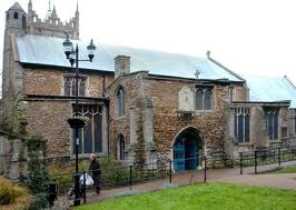
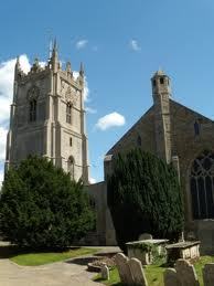
| Location | : | Wisbech, Fenland District, England |
| Coordinate | : | 52.6639880, 0.1626020 |
frequently asked questions (FAQ):
-
Where is St Peter & St Paul Churchyard?
St Peter & St Paul Churchyard is located at Wisbech, Fenland District ,Cambridgeshire ,England.
-
St Peter & St Paul Churchyard cemetery's updated grave count on graveviews.com?
0 memorials
-
Where are the coordinates of the St Peter & St Paul Churchyard?
Latitude: 52.6639880
Longitude: 0.1626020
Nearby Cemetories:
1. St Augustine Churchyard
Wisbech, Fenland District, England
Coordinate: 52.6679000, 0.1633300
2. Mount Pleasant Cemetery
Wisbech, Fenland District, England
Coordinate: 52.6719840, 0.1644770
3. All Saints Churchyard
Walsoken, Kings Lynn and West Norfolk Borough, England
Coordinate: 52.6721700, 0.1816130
4. All Saints
Wisbech, Fenland District, England
Coordinate: 52.6398010, 0.1707000
5. Elm Cemetery
Wisbech, Fenland District, England
Coordinate: 52.6360700, 0.1691800
6. St. Edmund Churchyard
Emneth, Kings Lynn and West Norfolk Borough, England
Coordinate: 52.6438200, 0.1989100
7. St Mary Churchyard
Wisbech St Mary, Fenland District, England
Coordinate: 52.6523950, 0.0983170
8. Gorefield Congregational Churchyard
Gorefield, Fenland District, England
Coordinate: 52.6865500, 0.0968700
9. St Paul Churchyard
Gorefield, Fenland District, England
Coordinate: 52.6873400, 0.0944700
10. Marshland St. James Cemetery
Marshland St James, Kings Lynn and West Norfolk Borough, England
Coordinate: 52.6604540, 0.2465520
11. St. Clement Churchyard
Outwell, Kings Lynn and West Norfolk Borough, England
Coordinate: 52.6096650, 0.2340700
12. St. Giles' Churchyard
Tydd St Giles, Fenland District, England
Coordinate: 52.7269470, 0.1118120
13. Outwell Cemetery
Outwell, Kings Lynn and West Norfolk Borough, England
Coordinate: 52.6092800, 0.2363600
14. Upwell Cemetery
Upwell, Kings Lynn and West Norfolk Borough, England
Coordinate: 52.6023700, 0.2229300
15. St. Peter's Churchyard
Upwell, Kings Lynn and West Norfolk Borough, England
Coordinate: 52.6018160, 0.2219280
16. Guyhirn Old Churchyard
Guyhirn, Fenland District, England
Coordinate: 52.6155700, 0.0714900
17. St. Peter's Churchyard
Walpole, Kings Lynn and West Norfolk Borough, England
Coordinate: 52.7284200, 0.2219100
18. Walpole St Andrew - Extension
Walpole, Kings Lynn and West Norfolk Borough, England
Coordinate: 52.7314600, 0.2162800
19. Walpole St Andrew
Walpole, Kings Lynn and West Norfolk Borough, England
Coordinate: 52.7349520, 0.2227630
20. Upwell Baptist Chapel
Upwell, Kings Lynn and West Norfolk Borough, England
Coordinate: 52.5878110, 0.2070450
21. Emmanual Anglican Cemetery
Parson Drove, Fenland District, England
Coordinate: 52.6574955, 0.0285929
22. St. Mary Churchyard
Tydd St Mary, South Holland District, England
Coordinate: 52.7456600, 0.1404600
23. St. John's Churchyard
Terrington St John, Kings Lynn and West Norfolk Borough, England
Coordinate: 52.7183750, 0.2778270
24. Tilney St. Lawrence Churchyard
Tilney St Lawrence, Kings Lynn and West Norfolk Borough, England
Coordinate: 52.7089510, 0.2923460