
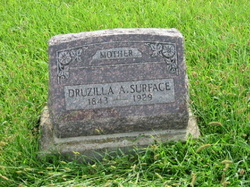
Druzilla Avis Whitted Surface
| Birth | : | 9 Jun 1843 Parke County, Indiana, USA |
| Death | : | 1 Feb 1929 Lyndon, Osage County, Kansas, USA |
| Burial | : | Park View Cemetery, Manteca, San Joaquin County, USA |
| Coordinate | : | 37.8617249, -121.2238312 |
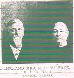
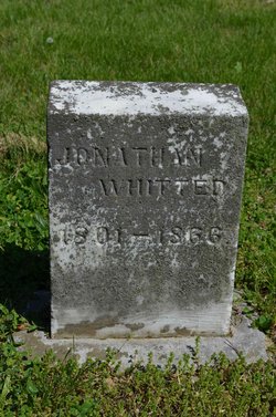
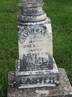
| Description | : | Druzilla 1st marriage to a gentleman by the name of William F Holstine on 3/11/1860 Parke County IN. They had one child. Both Mr Holstine and child died sometime after the end of the Civil War. Druzilla then married Calvin Carter on 10/12/1865 in Parke County IN. After Calvin Carter passed away Druzilla married Noah Surface on 9/9/1883 in Richland KS, taking with her several children by Calvins fisrt marriage and children he had with Druzilla. Her date of birth 6/9/1843 in Parke County, IN near Annapolis. Her Parents were Jonathan Whitted ID 6400893 and Nancy Rogers Clark ID 7407735 |
frequently asked questions (FAQ):
-
Where is Druzilla Avis Whitted Surface's memorial?
Druzilla Avis Whitted Surface's memorial is located at: Park View Cemetery, Manteca, San Joaquin County, USA.
-
When did Druzilla Avis Whitted Surface death?
Druzilla Avis Whitted Surface death on 1 Feb 1929 in Lyndon, Osage County, Kansas, USA
-
Where are the coordinates of the Druzilla Avis Whitted Surface's memorial?
Latitude: 37.8617249
Longitude: -121.2238312
Family Members:
Parent

Spouse
Siblings
Flowers:


Nearby Cemetories:
1. Congregation Adas Yeshuran of Stockton Cemetery
French Camp, San Joaquin County, USA
Coordinate: 37.8784065, -121.2740784
2. Congregation of Ahavas Achim Cemetery
French Camp, San Joaquin County, USA
Coordinate: 37.8778419, -121.2753067
3. Chinese Cemetery
French Camp, San Joaquin County, USA
Coordinate: 37.8819962, -121.2805862
4. East Union Cemetery
Manteca, San Joaquin County, USA
Coordinate: 37.8114014, -121.2350006
5. Atlanta Cemetery
Five Corners, San Joaquin County, USA
Coordinate: 37.8270035, -121.1420135
6. Collegeville Cemetery
Collegeville, San Joaquin County, USA
Coordinate: 37.9044800, -121.1466141
7. Citizens Cemetery
Stockton, San Joaquin County, USA
Coordinate: 37.9559410, -121.2769120
8. Thomas Lindsay Gravesite
San Joaquin County, USA
Coordinate: 37.9573110, -121.2918430
9. David Kelsey Gravesite
Stockton, San Joaquin County, USA
Coordinate: 37.9573110, -121.2918430
10. Temple Israel Cemetery
Stockton, San Joaquin County, USA
Coordinate: 37.9640541, -121.2784348
11. Stockton State Hospital Cemetery
Stockton, San Joaquin County, USA
Coordinate: 37.9663110, -121.2846850
12. San Joaquin Catholic Cemetery
Stockton, San Joaquin County, USA
Coordinate: 37.9707830, -121.2850190
13. Casa Bonita Mausoleum
Stockton, San Joaquin County, USA
Coordinate: 37.9752340, -121.2877800
14. Stockton Woodland Mausoleum
Stockton, San Joaquin County, USA
Coordinate: 37.9762400, -121.2878000
15. Stockton Rural Cemetery
Stockton, San Joaquin County, USA
Coordinate: 37.9794006, -121.2869034
16. Saint John's Catholic Cemetery
Escalon, San Joaquin County, USA
Coordinate: 37.7994537, -121.0705185
17. Central United Methodist Church Columbarium
Stockton, San Joaquin County, USA
Coordinate: 37.9825710, -121.3078170
18. Ripon Cemetery
Ripon, San Joaquin County, USA
Coordinate: 37.7420311, -121.1238708
19. Highland View Memorial Gardens
Farmington, San Joaquin County, USA
Coordinate: 37.9242935, -121.0008621
20. Linden Cemetery
Linden, San Joaquin County, USA
Coordinate: 38.0226707, -121.0889053
21. Tracy Mausoleum
Tracy, San Joaquin County, USA
Coordinate: 37.7250214, -121.4150696
22. Tracy Public Cemetery
Tracy, San Joaquin County, USA
Coordinate: 37.7251358, -121.4189453
23. Wood Colony Cemetery
Salida, Stanislaus County, USA
Coordinate: 37.6893730, -121.0682144
24. Good Shepherd Catholic Cemetery
Modesto, Stanislaus County, USA
Coordinate: 37.6853130, -121.0672890