
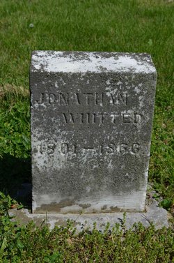
Jonathan Whitted
| Birth | : | 2 Jun 1801 North Carolina, USA |
| Death | : | 1866 Vermillion County, Indiana, USA |
| Burial | : | Whitstable Cemetery, Whitstable, City of Canterbury, England |
| Coordinate | : | 51.3529870, 1.0338530 |
| Description | : | Jonathan Whitted was the son of Mary Whitted of Orange County, North Carolina. Because of his illegitimate birth, the Orange County Court of Pleas and Quarter Sessions ordered that "Jonathan Whithed son of Mary Whithed now of the age of 4 years 2d June last be bound to Isaac Sugars until he arrives to lawful age to learn the art & mystery of a farmer." Jonathan married Nancy Rogers Clark in Orange County, North Carolina in 1821, and after the birth of their sixth child, the family moved to Indiana, settling in Parke County. Nancy died in 1857 and... Read More |
frequently asked questions (FAQ):
-
Where is Jonathan Whitted's memorial?
Jonathan Whitted's memorial is located at: Whitstable Cemetery, Whitstable, City of Canterbury, England.
-
When did Jonathan Whitted death?
Jonathan Whitted death on 1866 in Vermillion County, Indiana, USA
-
Where are the coordinates of the Jonathan Whitted's memorial?
Latitude: 51.3529870
Longitude: 1.0338530
Family Members:
Parent
Spouse

Siblings
Children
Flowers:


Nearby Cemetories:
1. All Saints Churchyard
Whitstable, City of Canterbury, England
Coordinate: 51.3558090, 1.0396670
2. St Alphege Churchyard
Whitstable, City of Canterbury, England
Coordinate: 51.3576330, 1.0251080
3. St. Alphege's Churchyard
Seasalter, City of Canterbury, England
Coordinate: 51.3432041, 1.0041740
4. St John the Baptist Churchyard
Swalecliffe, City of Canterbury, England
Coordinate: 51.3645500, 1.0667200
5. St Cosmus and St Damian Churchyard
Blean, City of Canterbury, England
Coordinate: 51.3052720, 1.0530480
6. Herne Bay Cemetery
Herne Bay, City of Canterbury, England
Coordinate: 51.3571810, 1.1304820
7. All Saints Churchyard
Graveney, Swale Borough, England
Coordinate: 51.3261450, 0.9447880
8. St Martins
Herne, City of Canterbury, England
Coordinate: 51.3500600, 1.1333200
9. St Martin's Churchyard
Herne, City of Canterbury, England
Coordinate: 51.3497060, 1.1334370
10. St Michael Churchyard
Hernhill, Swale Borough, England
Coordinate: 51.3077430, 0.9612050
11. Canterbury City Cemetery
Canterbury, City of Canterbury, England
Coordinate: 51.2843285, 1.0637640
12. St Nicholas Hospital Church
Harbledown, City of Canterbury, England
Coordinate: 51.2828200, 1.0536580
13. Christ Church Churchyard
Dunkirk, Swale Borough, England
Coordinate: 51.2916540, 0.9741890
14. St Michael and All Angels Church
Harbledown, City of Canterbury, England
Coordinate: 51.2824590, 1.0556800
15. Canterbury Jewish Cemetery
Canterbury, City of Canterbury, England
Coordinate: 51.2846135, 1.0706660
16. St. Dunstan Churchyard
Canterbury, City of Canterbury, England
Coordinate: 51.2836820, 1.0707800
17. St Bartholomew Churchyard
Goodnestone, Dover District, England
Coordinate: 51.3166220, 0.9322200
18. Sturry Cemetery
Sturry, City of Canterbury, England
Coordinate: 51.3058100, 1.1277700
19. St. John the Baptist Hospital Chapelyard
Canterbury, City of Canterbury, England
Coordinate: 51.2832713, 1.0837677
20. Holy Cross Church
Canterbury, City of Canterbury, England
Coordinate: 51.2811350, 1.0755710
21. St Nicholas Churchyard
Sturry, City of Canterbury, England
Coordinate: 51.2984830, 1.1201330
22. Westgate Gardens
Canterbury, City of Canterbury, England
Coordinate: 51.2805250, 1.0745040
23. St Gregory's Priory (defunct)
Canterbury, City of Canterbury, England
Coordinate: 51.2831127, 1.0855358
24. St Peter the Apostle Churchyard
Canterbury, City of Canterbury, England
Coordinate: 51.2807260, 1.0775370