E. Elaine Johnston Norman
| Birth | : | 23 Mar 1925 Holdrege, Phelps County, Nebraska, USA |
| Death | : | 8 Jul 2010 Holdrege, Phelps County, Nebraska, USA |
| Burial | : | St. Edmund's Churchyard, Taverham, Broadland District, England |
| Coordinate | : | 52.6789990, 1.1949460 |
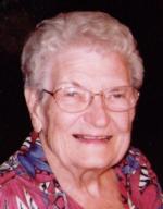
| Description | : | E. Elaine Norman, 85 years of age, of Holdrege, passed away on Thursday, July 8, 2010 at Phelps Memorial Health Center in Holdrege. Elaine was born on March 23, 1925 at Holdrege, the sixth of eight children born to James Bishop Johnston, Jr. and Edith (Carlson) Johnston. Elaine was baptized and confirmed at the Bethel Lutheran Church. She received her primary education from rural schools in Phelps County, and then graduated from Holdrege High School with the class of 1942. Following her education, she received her normal training and taught in a rural school for one year, prior to Nurses... Read More |
frequently asked questions (FAQ):
-
Where is E. Elaine Johnston Norman's memorial?
E. Elaine Johnston Norman's memorial is located at: St. Edmund's Churchyard, Taverham, Broadland District, England.
-
When did E. Elaine Johnston Norman death?
E. Elaine Johnston Norman death on 8 Jul 2010 in Holdrege, Phelps County, Nebraska, USA
-
Where are the coordinates of the E. Elaine Johnston Norman's memorial?
Latitude: 52.6789990
Longitude: 1.1949460
Family Members:
Parent
Spouse
Siblings
Flowers:
Nearby Cemetories:
1. St. Edmund's Churchyard
Taverham, Broadland District, England
Coordinate: 52.6789990, 1.1949460
2. St. Margaret's Churchyard
Drayton, Broadland District, England
Coordinate: 52.6773010, 1.2241980
3. St. Edmund's Churchyard
Costessey, South Norfolk District, England
Coordinate: 52.6660400, 1.2183410
4. Costessey Baptist Churchyard
Costessey, South Norfolk District, England
Coordinate: 52.6600122, 1.2116993
5. Our Lady & St. Walstan Churchyard
Costessey, South Norfolk District, England
Coordinate: 52.6583200, 1.2119300
6. St. Peter's Churchyard
Ringland, Broadland District, England
Coordinate: 52.6822900, 1.1552400
7. Costessey Parish Cemetery
Costessey, South Norfolk District, England
Coordinate: 52.6495927, 1.2040157
8. St Margaret Churchyard
Felthorpe, Broadland District, England
Coordinate: 52.7099700, 1.2105700
9. All Saints Churchyard
Horsford, Broadland District, England
Coordinate: 52.6913720, 1.2494360
10. St Margaret's Church
Morton on the Hill, Broadland District, England
Coordinate: 52.6987710, 1.1450960
11. Baptist Chapel Churchyard
Felthorpe, Broadland District, England
Coordinate: 52.7150000, 1.2008950
12. St. Peter's Churchyard
Easton, South Norfolk District, England
Coordinate: 52.6543660, 1.1478070
13. St. Andrew's Churchyard
Attlebridge, Broadland District, England
Coordinate: 52.7075040, 1.1504910
14. St Michael's Church
Bowthorpe, City of Norwich, England
Coordinate: 52.6359300, 1.2163600
15. St. Mary's New Burial Ground
Hellesdon, Broadland District, England
Coordinate: 52.6495480, 1.2520370
16. St. Mary's Churchyard
Hellesdon, Broadland District, England
Coordinate: 52.6486720, 1.2515280
17. All Saints Churchyard
Weston Longville, Broadland District, England
Coordinate: 52.6993460, 1.1262510
18. All Saints Churchyard
Weston Longville, Broadland District, England
Coordinate: 52.6990630, 1.1257670
19. St. Mary and St. Walstan Churchyard
Bawburgh, South Norfolk District, England
Coordinate: 52.6327480, 1.1796530
20. St Andrew's Churchyard
Honingham, Broadland District, England
Coordinate: 52.6573170, 1.1244600
21. Horsham St. Faith cemetery
Horsham St Faith, Broadland District, England
Coordinate: 52.6870250, 1.2758110
22. St. Mary and St. Andrew Churchyard
Horsham St Faith, Broadland District, England
Coordinate: 52.6880970, 1.2771330
23. Horsham St. Faith Priory
Horsham St Faith, Broadland District, England
Coordinate: 52.6888310, 1.2783290
24. Colney Woodland Burial Park
Colney, South Norfolk District, England
Coordinate: 52.6254580, 1.1991560


