

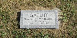
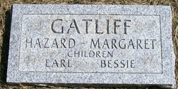
Earl Gatliff
| Birth | : | 1880 Morgan, Decatur County, Iowa, USA |
| Death | : | 13 Aug 1898 Morgan, Decatur County, Iowa, USA |
| Burial | : | St. Andrew's Parish of Old Cleeve Churchyard, Old Cleeve, West Somerset District, England |
| Coordinate | : | 51.1683560, -3.3733090 |
| Description | : | Earl was the son of Charles Hazard and Margaret Jane (Davis) Gatliff he died in Morgan Twp. Decatur, Iowa at the age of 18. Earl Gatliff Iowa Deaths and Burials, 1850-1990 name: Earl Gatliff gender: Male death date: 13 Aug 1898 death place: Morgan Twp., Decatur, Iowa age: 18 birth date: 1880 birthplace: Morgan Twp occupation: Farmer marital status: Single indexing project (batch) number: B86646-2 system origin: Iowa-EASy source film number: 1009362 Earl Gatliff United States Census, 1880 parents: Charles H. Gatliff, Margret Gatliff name: Earl Gatliff residence: Morgan, Decatur, Iowa birthdate: 1880 birthplace: Iowa, United States relationship to head: Son... Read More |
frequently asked questions (FAQ):
-
Where is Earl Gatliff's memorial?
Earl Gatliff's memorial is located at: St. Andrew's Parish of Old Cleeve Churchyard, Old Cleeve, West Somerset District, England.
-
When did Earl Gatliff death?
Earl Gatliff death on 13 Aug 1898 in Morgan, Decatur County, Iowa, USA
-
Where are the coordinates of the Earl Gatliff's memorial?
Latitude: 51.1683560
Longitude: -3.3733090
Family Members:
Parent

Siblings

Flowers:


Nearby Cemetories:
1. St. Andrew's Parish of Old Cleeve Churchyard
Old Cleeve, West Somerset District, England
Coordinate: 51.1683560, -3.3733090
2. Watchet Town Cemetery
Watchet, West Somerset District, England
Coordinate: 51.1745790, -3.3379850
3. St Decuman's Churchyard
Watchet, West Somerset District, England
Coordinate: 51.1757020, -3.3383800
4. St Nicholas Churchyard
Withycombe, West Somerset District, England
Coordinate: 51.1624530, -3.4096990
5. Saint John the Baptist Churchyard
Carhampton, West Somerset District, England
Coordinate: 51.1746000, -3.4186000
6. St Peter's Churchyard
Williton, West Somerset District, England
Coordinate: 51.1584870, -3.3235670
7. St Mary Church
Nettlecombe, West Somerset District, England
Coordinate: 51.1312930, -3.3491000
8. St. George's Churchyard
Sampford Brett, West Somerset District, England
Coordinate: 51.1538990, -3.3033380
9. Priory Churchyard of St. George
Dunster, West Somerset District, England
Coordinate: 51.1832000, -3.4459000
10. St. Giles Churchyard of Leighland
Old Cleeve, West Somerset District, England
Coordinate: 51.1199950, -3.3842729
11. George Street Cemetery
Dunster, West Somerset District, England
Coordinate: 51.1833740, -3.4483046
12. All Saints Churchyard
Monksilver, West Somerset District, England
Coordinate: 51.1287770, -3.3262800
13. Grabbist Hill Cemetery
Dunster, West Somerset District, England
Coordinate: 51.1820510, -3.4492540
14. Treborough Parish Churchyard
Treborough, West Somerset District, England
Coordinate: 51.1180220, -3.4147610
15. St. Audries Churchyard
West Quantoxhead, West Somerset District, England
Coordinate: 51.1688420, -3.2717650
16. St. Mary of Stogumber Churchyard
Stogumber, West Somerset District, England
Coordinate: 51.1276170, -3.2902340
17. Saint George Churchyard
Bicknoller, West Somerset District, England
Coordinate: 51.1472610, -3.2722430
18. Blesssed Virgin Mary Churchyard
Luxborough, West Somerset District, England
Coordinate: 51.1321490, -3.4680500
19. St. Martin de Tours Churchyard
Elworthy, West Somerset District, England
Coordinate: 51.1066110, -3.3113586
20. St. Petrock's Churchyard
Timberscombe, West Somerset District, England
Coordinate: 51.1680950, -3.4948210
21. St. Michael's Anglican Church Cemetery
Minehead, West Somerset District, England
Coordinate: 51.2110390, -3.4808250
22. Minehead Cemetery
Minehead, West Somerset District, England
Coordinate: 51.2050650, -3.4982030
23. St. Mary's Churchyard
East Quantoxhead, West Somerset District, England
Coordinate: 51.1855220, -3.2370690
24. St Mary Magdalene Churchyard
Withiel Florey, West Somerset District, England
Coordinate: 51.0906773, -3.4478871