Earl Orson Blair
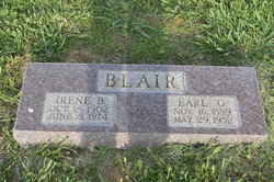
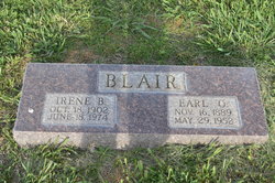
| Birth | : | 16 Nov 1889 Mayville, Tuscola County, Michigan, USA |
| Death | : | 29 May 1952 Lewellen, Garden County, Nebraska, USA |
| Burial | : | Brule Cemetery, Brule, Keith County, USA |
| Coordinate | : | 41.1060982, -101.8822021 |
| Description | : | Earl Orson Blair Nov 16,1889-May 29,1952 Earl Orson Blair, son of Edwin and Mary Blair, was born at mayville, November 16, 1889 and passed away at Lewellen, Nebraska, May 29, 1952, at the age of 62. Funeral services were held Monday, June 2, from the Methodist Church in Ogallala, Neb., and burial was in the Brule Cemetery. Fr. Harry E. Hess officiated. Mr. Blair spent his boyhood days on the farm where he was born and attended schoolhere. In 1909 the family moved to Deuel County, Neb. On April 8, 1921, he married Irene B. Campbell at North Platte, Neb., and... Read More |
frequently asked questions (FAQ):
-
Where is Earl Orson Blair's memorial?
Earl Orson Blair's memorial is located at: Brule Cemetery, Brule, Keith County, USA.
-
When did Earl Orson Blair death?
Earl Orson Blair death on 29 May 1952 in Lewellen, Garden County, Nebraska, USA
-
Where are the coordinates of the Earl Orson Blair's memorial?
Latitude: 41.1060982
Longitude: -101.8822021
Family Members:
Parent
Spouse
Siblings
Children
Flowers:
Nearby Cemetories:
1. Brule Cemetery
Brule, Keith County, USA
Coordinate: 41.1060982, -101.8822021
2. Ogallala Cemetery
Ogallala, Keith County, USA
Coordinate: 41.1286011, -101.7472000
3. Boot Hill Cemetery
Ogallala, Keith County, USA
Coordinate: 41.1324997, -101.7256012
4. Big Springs Cemetery
Big Springs, Deuel County, USA
Coordinate: 41.0592003, -102.0931015
5. Lemoyne Cemetery
Lemoyne, Keith County, USA
Coordinate: 41.2723000, -101.8123000
6. Trinity Lutheran Cemetery
Grant, Perkins County, USA
Coordinate: 40.9605000, -101.7478000
7. Day Cemetery
Deuel County, USA
Coordinate: 41.1921997, -102.1331024
8. Zion Cemetery
Deuel County, USA
Coordinate: 41.1641998, -102.1530991
9. Saint John's Lutheran Church Cemetery
Ogallala, Keith County, USA
Coordinate: 41.0617000, -101.5983000
10. Ash Hollow Cemetery
Lewellen, Garden County, USA
Coordinate: 41.3083000, -102.1252975
11. Plum Creek Cemetery
Garden County, USA
Coordinate: 41.3469009, -102.0828018
12. Fairview Cemetery
Grant, Perkins County, USA
Coordinate: 40.8372002, -101.7391968
13. Hillside Cemetery
Julesburg, Sedgwick County, USA
Coordinate: 40.9692001, -102.2406006
14. Ash Creek Cemetery
Lewellen, Garden County, USA
Coordinate: 41.3521996, -102.1205978
15. Pickard Cemetery
Keith County, USA
Coordinate: 41.0482240, -101.4809320
16. Durham Cemetery
Garden County, USA
Coordinate: 41.3314018, -102.2074966
17. Green Cemetery
Julesburg, Sedgwick County, USA
Coordinate: 40.8650000, -102.2284090
18. Berea Lutheran Cemetery
Chappell, Deuel County, USA
Coordinate: 41.2008900, -102.3439080
19. Fairview Cemetery
Garden County, USA
Coordinate: 41.4524994, -102.0233002
20. Madrid Cemetery
Madrid, Perkins County, USA
Coordinate: 40.8371510, -101.5380900
21. Venango Cemetery
Venango, Perkins County, USA
Coordinate: 40.7416992, -102.0175018
22. Ovid Cemetery
Ovid, Sedgwick County, USA
Coordinate: 40.9756012, -102.3632965
23. Mennonite Cemetery
Chappell, Deuel County, USA
Coordinate: 41.1244011, -102.3993988
24. Paxton Cemetery
Paxton, Keith County, USA
Coordinate: 41.1088982, -101.3569031

