
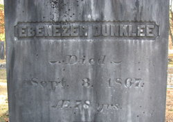

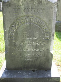
Ebenezer Dunklee
| Birth | : | 10 May 1789 Amherst, Hillsborough County, New Hampshire, USA |
| Death | : | 3 Sep 1867 Hollis, Hillsborough County, New Hampshire, USA |
| Burial | : | Jonesboro City Cemetery, Jonesboro, Clayton County, USA |
| Coordinate | : | 33.5299988, -84.3486023 |
| Description | : | Ebenezer inherited his Father's homestead and worked in the mill of his Father-in-law which was at 224 South Merrimack Road at the head of Silver Lake where the brook runs into Pennichuck Pond. Benjamin Wright sold land and the mill to Ebenezer some time before 1848. This was the beginning of Duncklee ownership until around 1906. There were two mills on the site; one a grist mill and the other a saw mill. |
frequently asked questions (FAQ):
-
Where is Ebenezer Dunklee's memorial?
Ebenezer Dunklee's memorial is located at: Jonesboro City Cemetery, Jonesboro, Clayton County, USA.
-
When did Ebenezer Dunklee death?
Ebenezer Dunklee death on 3 Sep 1867 in Hollis, Hillsborough County, New Hampshire, USA
-
Where are the coordinates of the Ebenezer Dunklee's memorial?
Latitude: 33.5299988
Longitude: -84.3486023
Family Members:
Parent

Spouse
Siblings
Children
Flowers:


Nearby Cemetories:
1. Jonesboro City Cemetery
Jonesboro, Clayton County, USA
Coordinate: 33.5299988, -84.3486023
2. Confederate Cemetery
Clayton County, USA
Coordinate: 33.5303001, -84.3535995
3. Chapman-Morrow Cemetery
Jonesboro, Clayton County, USA
Coordinate: 33.5245740, -84.3495400
4. Camp Family Cemetery
Jonesboro, Clayton County, USA
Coordinate: 33.5156010, -84.3386240
5. Camp Marker
Jonesboro, Clayton County, USA
Coordinate: 33.5214420, -84.3254220
6. Babb Cemetery
Jonesboro, Clayton County, USA
Coordinate: 33.5348170, -84.3737460
7. Hamrick-Tankersley Family Cemetery
Jonesboro, Clayton County, USA
Coordinate: 33.5080150, -84.3658160
8. Mann Cemetery
Clayton County, USA
Coordinate: 33.5229492, -84.3818436
9. Bethel Baptist Church Cemetery
Clayton County, USA
Coordinate: 33.5193660, -84.3812510
10. Smith Family Cemetery
Riverdale, Clayton County, USA
Coordinate: 33.5510720, -84.3741330
11. Mundy Cemetery
Clayton County, USA
Coordinate: 33.5050011, -84.3750000
12. Allen Family Cemetery #2
Clayton County, USA
Coordinate: 33.5090050, -84.3168370
13. Allen Family Cemetery #1
Clayton County, USA
Coordinate: 33.5465000, -84.3103900
14. Mount Zion Cemetery
Morrow, Clayton County, USA
Coordinate: 33.5614014, -84.3214035
15. Sherwood Memorial Park and Mausoleum
Jonesboro, Clayton County, USA
Coordinate: 33.5673300, -84.3718200
16. Morrow Cemetery
Morrow, Clayton County, USA
Coordinate: 33.5774994, -84.3368988
17. Old Spivey Cemetery
Stockbridge, Henry County, USA
Coordinate: 33.5425859, -84.2889050
18. Roberts Family Cemetery
Riverdale, Clayton County, USA
Coordinate: 33.5253050, -84.4102520
19. Noahs Ark Church Cemetery
Jonesboro, Clayton County, USA
Coordinate: 33.4986000, -84.2953033
20. Saint Augustine of Canterbury Episcopal Church Col
Morrow, Clayton County, USA
Coordinate: 33.5844150, -84.3504820
21. Allen Waggoner Cemetery
Jonesboro, Clayton County, USA
Coordinate: 33.4902650, -84.3933140
22. Carver Memorial Gardens
Jonesboro, Clayton County, USA
Coordinate: 33.5797005, -84.3792038
23. Hebron Primitive Baptist Cemetery
Jonesboro, Clayton County, USA
Coordinate: 33.4733500, -84.3386450
24. Philadelphia Presbyterian Church Cemetery
Forest Park, Clayton County, USA
Coordinate: 33.5900002, -84.3786011