
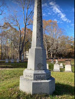
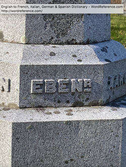
Ebenezer Wing
| Birth | : | 22 Dec 1757 Bourne, Barnstable County, Massachusetts, USA |
| Death | : | 29 Oct 1822 Wayne, Kennebec County, Maine, USA |
| Burial | : | Woodland Cemetery, Cleveland, Cuyahoga County, USA |
| Coordinate | : | 41.4900017, -81.6425018 |
| Plot | : | Section 5, lot 6 |
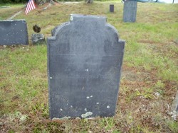
| Inscription | : | No stone currently in Cemetery. Architectural Plan (circa 1893) lists his burial in Section 5, lot 6 |
| Description | : | born at Pocasset, originally part of Sandwich, but later Bourne. Originally buried in the original Wing Cemetery in Wayne (located immediately north of the new "Ring" Cemetery). Reinterred when the new cemetery created. |
frequently asked questions (FAQ):
-
Where is Ebenezer Wing's memorial?
Ebenezer Wing's memorial is located at: Woodland Cemetery, Cleveland, Cuyahoga County, USA.
-
When did Ebenezer Wing death?
Ebenezer Wing death on 29 Oct 1822 in Wayne, Kennebec County, Maine, USA
-
Where are the coordinates of the Ebenezer Wing's memorial?
Latitude: 41.4900017
Longitude: -81.6425018
Family Members:
Parent

Spouse
Siblings
Children
Flowers:


Nearby Cemetories:
1. Woodland Cemetery
Cleveland, Cuyahoga County, USA
Coordinate: 41.4900017, -81.6425018
2. Saint John Cemetery
Cleveland, Cuyahoga County, USA
Coordinate: 41.4860992, -81.6408005
3. Saint Josephs Cemetery
Cleveland, Cuyahoga County, USA
Coordinate: 41.4869003, -81.6318970
4. Trinity Cathedral Crypt
Cleveland, Cuyahoga County, USA
Coordinate: 41.5013350, -81.6741750
5. Epworth Euclid United Methodist Church Columbarium
Euclid, Cuyahoga County, USA
Coordinate: 41.5058200, -81.6124990
6. Baxter Cemetery
Cleveland, Cuyahoga County, USA
Coordinate: 41.4596596, -81.6432800
7. Cleveland Museum of Natural History
Cleveland, Cuyahoga County, USA
Coordinate: 41.5115700, -81.6130905
8. Erie Street Cemetery
Cleveland, Cuyahoga County, USA
Coordinate: 41.4972687, -81.6831131
9. Church of the Covenant Columbarium
Cleveland, Cuyahoga County, USA
Coordinate: 41.5079200, -81.6068400
10. Cathedral of Saint John the Evangelist Crypt
Cleveland, Cuyahoga County, USA
Coordinate: 41.5026817, -81.6886139
11. Harvard Grove Cemetery
Cleveland, Cuyahoga County, USA
Coordinate: 41.4522040, -81.6471880
12. Ontario Street Cemetery (Defunct)
Cleveland, Cuyahoga County, USA
Coordinate: 41.4982200, -81.6920100
13. Soldiers and Sailors Monument
Cleveland, Cuyahoga County, USA
Coordinate: 41.4994965, -81.6928864
14. East Cleveland Township Cemetery
Cleveland, Cuyahoga County, USA
Coordinate: 41.5149994, -81.6010971
15. Lansing Cemetery
Cleveland, Cuyahoga County, USA
Coordinate: 41.4502983, -81.6492004
16. Lake View Cemetery
Cleveland, Cuyahoga County, USA
Coordinate: 41.5130997, -81.5982971
17. Old Stone Church Columbarium
Cleveland, Cuyahoga County, USA
Coordinate: 41.5004030, -81.6947480
18. Harvard Cemetery
Cleveland, Cuyahoga County, USA
Coordinate: 41.4485321, -81.6483917
19. Scranton Road Cemetery
Cleveland, Cuyahoga County, USA
Coordinate: 41.4733391, -81.6962891
20. Saint Pauls Episcopal Church Columbarium
Cleveland Heights, Cuyahoga County, USA
Coordinate: 41.4956350, -81.5812450
21. Fairmount Presbyterian Church Columbarium
Cleveland Heights, Cuyahoga County, USA
Coordinate: 41.4932930, -81.5801210
22. Monroe Street Cemetery
Cleveland, Cuyahoga County, USA
Coordinate: 41.4787700, -81.7066600
23. Calvary Cemetery
Cleveland, Cuyahoga County, USA
Coordinate: 41.4449900, -81.6147300
24. Mayfield Cemetery
Cleveland Heights, Cuyahoga County, USA
Coordinate: 41.5133018, -81.5821991