
Elizabeth Wing Fuller
| Birth | : | 6 Aug 1746 Bourne, Barnstable County, Massachusetts, USA |
| Death | : | 3 Aug 1826 Wayne, Kennebec County, Maine, USA |
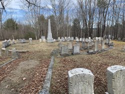
| Burial | : | Mount Hope Cemetery, Frankfort, Marshall County, USA |
| Coordinate | : | 39.6025009, -96.4072037 |
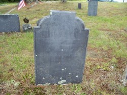
| Inscription | : | [Slate stone, Willow tree design] In memory of Mrs. Elizabeth Fuller wife of Capt. Job Fuller who died Aug. 5th 1826 aged 80 years. |
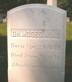
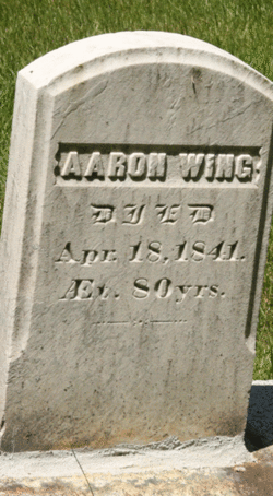
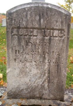
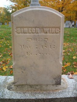
| Description | : | Elizabeth was born in Pocasset. At the time of her birth it was part of the town of Sandwich, Mass., but in 1884 it was separated and incorporated as the town of Bourne. She and her husband, Job Fuller, were the first white settlers of what is now the town of Wayne, ME. They deeded part of their homestead to be the cemetery where they are buried. The Wayne VRs have Elizabeth's date of death (listed under her parents, Simeon & Mary Wing) as Aug. 3, 1826. Her gravestone states she died Aug 5, 1826. |
frequently asked questions (FAQ):
-
Where is Elizabeth Wing Fuller's memorial?
Elizabeth Wing Fuller's memorial is located at: Mount Hope Cemetery, Frankfort, Marshall County, USA.
-
When did Elizabeth Wing Fuller death?
Elizabeth Wing Fuller death on 3 Aug 1826 in Wayne, Kennebec County, Maine, USA
-
Where are the coordinates of the Elizabeth Wing Fuller's memorial?
Latitude: 39.6025009
Longitude: -96.4072037
Family Members:
Parent

Spouse
Siblings
Children
Flowers:


Nearby Cemetories:
1. Mount Hope Cemetery
Frankfort, Marshall County, USA
Coordinate: 39.6025009, -96.4072037
2. Cedar Hill Cemetery
Blaine, Pottawatomie County, USA
Coordinate: 39.5619011, -96.4633026
3. Berg Cemetery
Blaine, Pottawatomie County, USA
Coordinate: 39.5370800, -96.3883700
4. Barrett Cemetery
Frankfort, Marshall County, USA
Coordinate: 39.6605988, -96.4507980
5. Saint Josephs Catholic Cemetery
Lillis, Marshall County, USA
Coordinate: 39.6020100, -96.3141800
6. Wells Cemetery
Marshall County, USA
Coordinate: 39.6632996, -96.4800034
7. Maple Grove Cemetery
Wheaton, Pottawatomie County, USA
Coordinate: 39.5233002, -96.3591995
8. Antioch Cemetery
Frankfort, Marshall County, USA
Coordinate: 39.6383018, -96.5274963
9. Pleasant Hill Cemetery
Wheaton, Pottawatomie County, USA
Coordinate: 39.5508000, -96.2864000
10. Frankfort Cemetery
Frankfort, Marshall County, USA
Coordinate: 39.7106018, -96.4253006
11. Proctor Cemetery
Marshall County, USA
Coordinate: 39.5788994, -96.5475006
12. Mount Calvary Catholic Cemetery
Blaine, Pottawatomie County, USA
Coordinate: 39.4872000, -96.4083000
13. Calvary Cemetery
Frankfort, Marshall County, USA
Coordinate: 39.7188988, -96.4272003
14. Morrison Cemetery
Vliets, Marshall County, USA
Coordinate: 39.7122002, -96.3527985
15. Saint Luke Lutheran North Cemetery
Wheaton, Pottawatomie County, USA
Coordinate: 39.5037003, -96.3143997
16. Saint Michaels Cemetery
Wheaton, Pottawatomie County, USA
Coordinate: 39.4972000, -96.3146973
17. Wheaton Congregational Cemetery
Wheaton, Pottawatomie County, USA
Coordinate: 39.4935989, -96.3133011
18. Spring Creek Cemetery
Fostoria, Pottawatomie County, USA
Coordinate: 39.4939003, -96.5278015
19. Huff Cemetery
Pottawatomie County, USA
Coordinate: 39.4650002, -96.4582977
20. Saint Pauls Lutheran Cemetery
Duluth, Pottawatomie County, USA
Coordinate: 39.5257988, -96.2311020
21. Vermillion Cemetery
Vermillion, Marshall County, USA
Coordinate: 39.7235985, -96.2763977
22. Moodyville Cemetery
Westmoreland, Pottawatomie County, USA
Coordinate: 39.4435997, -96.3833008
23. Mulberry Cemetery
Nemaha County, USA
Coordinate: 39.6314011, -96.2014008
24. Neuchatel Cemetery
Neuchatel, Nemaha County, USA
Coordinate: 39.5685196, -96.2015381