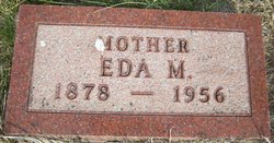
Eda Magdalene Huckfeldt Pfeil
| Birth | : | 29 Mar 1878 Adams County, Nebraska, USA |
| Death | : | 6 May 1956 Hastings, Adams County, Nebraska, USA |
| Burial | : | Harper Cemetery, Harpers Ferry, Jefferson County, USA |
| Coordinate | : | 39.3236847, -77.7345352 |
| Plot | : | Block 4, Lot 9, Space 3 |
| Inscription | : | Mother |
| Description | : | The Hastings Daily Tribune (Hastings, NE), Friday, February 19, 1897; pg. 1 The marriage licenses issued this week from the county judge's office are: Edwin Pfeil and Ida M. Huckfeldt. ====================== The Hastings Daily Tribune (Hastings, NE), Wednesday, February 24, 1897; pg. 8 LOCAL HAPPENINGS. Edwin Pfeil and Miss Eda M. Huckfeldt were married last Wednesday evening, at the bride's home in West Hastings. =========================== The Hastings Daily Tribune (Hastings, NE), Monday, May 7, 1956; pg. 13 Mrs. Eda M. Pfeil Dies at 78 Years Mrs. Eda M. Pfeil, 78, whose home was... Read More |
frequently asked questions (FAQ):
-
Where is Eda Magdalene Huckfeldt Pfeil's memorial?
Eda Magdalene Huckfeldt Pfeil's memorial is located at: Harper Cemetery, Harpers Ferry, Jefferson County, USA.
-
When did Eda Magdalene Huckfeldt Pfeil death?
Eda Magdalene Huckfeldt Pfeil death on 6 May 1956 in Hastings, Adams County, Nebraska, USA
-
Where are the coordinates of the Eda Magdalene Huckfeldt Pfeil's memorial?
Latitude: 39.3236847
Longitude: -77.7345352
Family Members:
Parent
Spouse
Siblings
Children
Flowers:
Nearby Cemetories:
1. Saint Peter's Cemetery
Harpers Ferry, Jefferson County, USA
Coordinate: 39.3213806, -77.7480927
2. Cedar Hill Cemetery
Harpers Ferry, Jefferson County, USA
Coordinate: 39.3283520, -77.7524420
3. Fairview Lutheran Cemetery
Bolivar, Jefferson County, USA
Coordinate: 39.3215700, -77.7567500
4. Virts Farm Cemetery
Sandy Hook, Washington County, USA
Coordinate: 39.3299675, -77.6966705
5. Ebenezer United Methodist Episcopal Church Cemeter
Neersville, Loudoun County, USA
Coordinate: 39.2957878, -77.7196045
6. Moler Graveyard
Halltown, Jefferson County, USA
Coordinate: 39.3188400, -77.7739900
7. Allstadt Graveyard
Halltown, Jefferson County, USA
Coordinate: 39.3145270, -77.7732030
8. Derry Cemetery
Neersville, Loudoun County, USA
Coordinate: 39.2920500, -77.7317900
9. Silver Grove Cemetery
Harpers Ferry, Jefferson County, USA
Coordinate: 39.2962044, -77.7552686
10. Payne's Hill Cemetery
Halltown, Jefferson County, USA
Coordinate: 39.3190730, -77.7810570
11. Old Ebenezer Methodist Episcopal Cemetery
Neersville, Loudoun County, USA
Coordinate: 39.2900543, -77.7141190
12. Moler Cemetery
Moler Crossroads, Jefferson County, USA
Coordinate: 39.3672700, -77.7495100
13. Mount Moriah Baptist Church Cemetery
Washington County, USA
Coordinate: 39.3535995, -77.6908035
14. Moler Cemetery
Bakerton, Jefferson County, USA
Coordinate: 39.3673700, -77.7496000
15. Garrett's Mill Assemblies of God Cemetery
Garretts Mill, Washington County, USA
Coordinate: 39.3527184, -77.6881485
16. Norris Cemetery
Garretts Mill, Washington County, USA
Coordinate: 39.3463968, -77.6781411
17. Hageley Cemetery
Bakerton, Jefferson County, USA
Coordinate: 39.3641838, -77.7730423
18. Samples Manor Cemetery
Samples Manor, Washington County, USA
Coordinate: 39.3732262, -77.7216568
19. Knoxville Reformed Cemetery
Knoxville, Frederick County, USA
Coordinate: 39.3288994, -77.6647034
20. Grove Cemetery
Keyes Ferry Acres, Jefferson County, USA
Coordinate: 39.2741014, -77.7644080
21. Flanegan Cemetery
Bakerton, Jefferson County, USA
Coordinate: 39.3750000, -77.7620000
22. Knoxville Mountain Cemetery
Knoxville, Frederick County, USA
Coordinate: 39.3395000, -77.6649000
23. Saint Pauls Lutheran Church Cemetery
Neersville, Loudoun County, USA
Coordinate: 39.2675018, -77.7261124
24. Mount Zion AME Church Cemetery
Reedson, Jefferson County, USA
Coordinate: 39.3492120, -77.8001050

