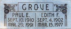
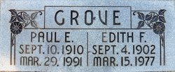
Edith Fay Greninger Grove
| Birth | : | 4 Sep 1902 Carthage, Jasper County, Missouri, USA |
| Death | : | 15 Mar 1977 Placer County, California, USA |
| Burial | : | Worcester County Memorial Park, Paxton, Worcester County, USA |
| Coordinate | : | 42.3245697, -71.9308777 |
| Plot | : | N/C-8-133-6 |
frequently asked questions (FAQ):
-
Where is Edith Fay Greninger Grove's memorial?
Edith Fay Greninger Grove's memorial is located at: Worcester County Memorial Park, Paxton, Worcester County, USA.
-
When did Edith Fay Greninger Grove death?
Edith Fay Greninger Grove death on 15 Mar 1977 in Placer County, California, USA
-
Where are the coordinates of the Edith Fay Greninger Grove's memorial?
Latitude: 42.3245697
Longitude: -71.9308777
Family Members:
Parent
Spouse
Siblings
Flowers:

ALL RETURN AGAIN---- It is the secret of the world that all things subsist and do not die, but only retire a little from sight and afterwards return again. Nothing is dead; men feign themselves dead, and endure mock funerals and mournful obituaries, and there they stand looking out of the window, sound and well, in some new strange disguise. Jesus is not dead; he is very well alive; nor John, nor Paul, nor Mahomet, nor Aristotle; at times we believe we have seen them all, and could easily tell the names under which they go. Ralph Waldo Emerson Read less
Left by Anonymous on 24 Sep 2009

Left by Anonymous on 25 Apr 2019
Nearby Cemetories:
1. Worcester County Memorial Park
Paxton, Worcester County, USA
Coordinate: 42.3245697, -71.9308777
2. Mooreland Cemetery
Paxton, Worcester County, USA
Coordinate: 42.3280800, -71.9321000
3. Paxton Center Cemetery
Paxton, Worcester County, USA
Coordinate: 42.3128900, -71.9277700
4. Putnam Farm Cemetery
Rutland, Worcester County, USA
Coordinate: 42.3484010, -71.9771420
5. Elliot Hill Burial Ground
Leicester, Worcester County, USA
Coordinate: 42.2802200, -71.9145500
6. West Rutland Cemetery
Rutland, Worcester County, USA
Coordinate: 42.3561970, -71.9897170
7. Saint Mary Cemetery
Holden, Worcester County, USA
Coordinate: 42.3522400, -71.8684200
8. Grove Cemetery
Holden, Worcester County, USA
Coordinate: 42.3520400, -71.8672700
9. Old Burial Ground
Rutland, Worcester County, USA
Coordinate: 42.3756000, -71.9578000
10. Park Avenue Cemetery
Holden, Worcester County, USA
Coordinate: 42.3514200, -71.8656900
11. Rutland Rural Cemetery
Rutland, Worcester County, USA
Coordinate: 42.3790100, -71.9447500
12. Old Burying Ground
Holden, Worcester County, USA
Coordinate: 42.3505800, -71.8626000
13. Saint Joseph's Abbey Grounds
Spencer, Worcester County, USA
Coordinate: 42.2935500, -71.9990800
14. Saint Francis Episcopal Church Memorial Garden
Holden, Worcester County, USA
Coordinate: 42.3522800, -71.8588700
15. Quaker Cemetery
Leicester, Worcester County, USA
Coordinate: 42.2635600, -71.8960300
16. Smith Family Cemetery
Rutland, Worcester County, USA
Coordinate: 42.3946064, -71.9231169
17. Nazareth Home for Boys Cemetery
Leicester, Worcester County, USA
Coordinate: 42.2600000, -71.8892000
18. Green Hollow Cemetery
Oakham, Worcester County, USA
Coordinate: 42.3549995, -72.0243988
19. South Cemetery
Oakham, Worcester County, USA
Coordinate: 42.3382988, -72.0374985
20. Rawson Brook Burial Ground
Leicester, Worcester County, USA
Coordinate: 42.2453900, -71.9152600
21. Saint Josephs Cemetery
Leicester, Worcester County, USA
Coordinate: 42.2467003, -71.8874969
22. Pine Grove Cemetery
Leicester, Worcester County, USA
Coordinate: 42.2402992, -71.9124985
23. Rutland Prison Camp Cemetery
Rutland, Worcester County, USA
Coordinate: 42.3988500, -71.9923800
24. Oakham Center Cemetery
Oakham, Worcester County, USA
Coordinate: 42.3540000, -72.0421400


