
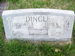
Edith Mae Kurtz Dingle
| Birth | : | 11 Sep 1900 Maryland, USA |
| Death | : | 10 Oct 1958 Hagerstown, Washington County, Maryland, USA |
| Burial | : | Saint Mary and All Saints Churchyard, Whalley, Ribble Valley Borough, England |
| Coordinate | : | 53.8211890, -2.4078080 |
| Description | : | OBITUARY : MRS. EDITH M. DINGLE, 58, wife of Benjamin R. Dingle, Cullen, died at about 6 p.m. Friday at Washington County Hospital, Hagerstown. Besides her husband she is survived by the following children: Raymond and Ernest, Blue Ridge Summit; Joseph H., Highfield; Clarence, Cascade; Stanley, Charmian, Ivan, Funkstown; Victor, Pen Mar; Miss Goldie Dingle and David Dingle, at home; one brother, Pierston Bowers, Westminster, two sisters, Mrs. Marie Moser, Sabillasville, and Miss Eleanor Bowers, Westminster, and sixteen grandchildren also survive. The body rests at the Creager Funeral Home, Thurmont, where friends may... Read More |
frequently asked questions (FAQ):
-
Where is Edith Mae Kurtz Dingle's memorial?
Edith Mae Kurtz Dingle's memorial is located at: Saint Mary and All Saints Churchyard, Whalley, Ribble Valley Borough, England.
-
When did Edith Mae Kurtz Dingle death?
Edith Mae Kurtz Dingle death on 10 Oct 1958 in Hagerstown, Washington County, Maryland, USA
-
Where are the coordinates of the Edith Mae Kurtz Dingle's memorial?
Latitude: 53.8211890
Longitude: -2.4078080
Family Members:
Parent
Spouse

Siblings
Children

Flowers:


Nearby Cemetories:
1. Saint Mary and All Saints Churchyard
Whalley, Ribble Valley Borough, England
Coordinate: 53.8211890, -2.4078080
2. Whalley, Wiswell and Barrow Cemetery
Whalley, Ribble Valley Borough, England
Coordinate: 53.8308490, -2.4057280
3. Queen Mary's Military Hospital Cemetery
Whalley, Ribble Valley Borough, England
Coordinate: 53.8337490, -2.4127930
4. Calderstones Hospital Cemetery
Whalley, Ribble Valley Borough, England
Coordinate: 53.8338710, -2.4147160
5. St. Leonard Old Churchyard
Langho, Ribble Valley Borough, England
Coordinate: 53.8178590, -2.4552870
6. Brockhall Hospital Cemetery
Brockhall Village, Ribble Valley Borough, England
Coordinate: 53.8186850, -2.4560220
7. All Hallows Churchyard
Great Mitton, Ribble Valley Borough, England
Coordinate: 53.8461500, -2.4339000
8. St. Bartholomew's Churchyard
Great Harwood, Hyndburn Borough, England
Coordinate: 53.7900670, -2.4055460
9. St. John's Churchyard
Read, Ribble Valley Borough, England
Coordinate: 53.8088800, -2.3585600
10. Our Lady and Saint Hubert
Great Harwood, Hyndburn Borough, England
Coordinate: 53.7851070, -2.4009760
11. Great Harwood Cemetery
Great Harwood, Hyndburn Borough, England
Coordinate: 53.7796190, -2.4091680
12. St James Churchyard
Clitheroe, Ribble Valley Borough, England
Coordinate: 53.8659600, -2.3922700
13. St James Church
Altham, Hyndburn Borough, England
Coordinate: 53.7928940, -2.3465250
14. Saint Nicholas Parish Churchyard
Sabden, Ribble Valley Borough, England
Coordinate: 53.8346503, -2.3332764
15. St Marys Burial Ground
Clayton-le-Moors, Hyndburn Borough, England
Coordinate: 53.7792778, -2.3705871
16. St John the Evangelist Churchyard
Hurst Green, Ribble Valley Borough, England
Coordinate: 53.8358000, -2.4852530
17. St. Joseph Roman Catholic Churchyard
Hurst Green, Ribble Valley Borough, England
Coordinate: 53.8409900, -2.4820600
18. Barnes Square Weslyan Methodist Churchyard
Clayton-le-Moors, Hyndburn Borough, England
Coordinate: 53.7744350, -2.3853800
19. All Saints Churchyard
Clayton-le-Moors, Hyndburn Borough, England
Coordinate: 53.7738520, -2.3881690
20. Stonyhurst College Burial Ground
Hurst Green, Ribble Valley Borough, England
Coordinate: 53.8403420, -2.4840310
21. Trinity Methodist Churchyard
Clitheroe, Ribble Valley Borough, England
Coordinate: 53.8709060, -2.3954550
22. St Mary Magdalene Churchyard
Clitheroe, Ribble Valley Borough, England
Coordinate: 53.8740980, -2.3903420
23. St Peter Churchyard
Salesbury, Ribble Valley Borough, England
Coordinate: 53.7915000, -2.4859100
24. St Leonard Churchyard Extension
Padiham, Burnley Borough, England
Coordinate: 53.7991800, -2.3222000