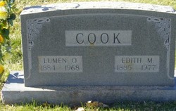
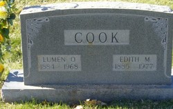
Edith Mae Wyscaver Cook
| Birth | : | 11 Mar 1885 Kansas, USA |
| Death | : | 4 Apr 1977 Canon City, Fremont County, Colorado, USA |
| Burial | : | Cherry Grove Cemetery, Clare, Clare County, USA |
| Coordinate | : | 43.8250000, -84.7588880 |
| Plot | : | Sect. 35, blk. 18, Lot O, Grave 3 |
| Description | : | EDITH COOK, CANON CITY, DIED TODAY Mrs. Edith M. Cook, late of 925 Park Ave., died today at the Hildebrand Care Center of an extended illness. She was born March 10, 1885 in Ruben County, Kansas., and was 92. Mrs. Cook was a 42-year resident of Canon City and the state. She was a housewife and favored the Protestant faith. On May 15, 1905 she married Lumen O. Cook in Hill City, Kan. He preceded her in death. Survivors include a daughter, Thelma Jackson, of Hill City, Kan.; three grandsons, one granddaughter; 17... Read More |
frequently asked questions (FAQ):
-
Where is Edith Mae Wyscaver Cook's memorial?
Edith Mae Wyscaver Cook's memorial is located at: Cherry Grove Cemetery, Clare, Clare County, USA.
-
When did Edith Mae Wyscaver Cook death?
Edith Mae Wyscaver Cook death on 4 Apr 1977 in Canon City, Fremont County, Colorado, USA
-
Where are the coordinates of the Edith Mae Wyscaver Cook's memorial?
Latitude: 43.8250000
Longitude: -84.7588880
Family Members:
Parent
Spouse
Siblings
Flowers:
Nearby Cemetories:
1. Cherry Grove Cemetery
Clare, Clare County, USA
Coordinate: 43.8250000, -84.7588880
2. Saint Cecilia Cemetery
Clare, Clare County, USA
Coordinate: 43.8263890, -84.7588890
3. Dover Amish Cemetery
Clare, Clare County, USA
Coordinate: 43.8869800, -84.7730590
4. Thompson Cemetery
Sheridan Township, Clare County, USA
Coordinate: 43.8772220, -84.7061110
5. East Colonville Amish Cemetery
Colonville, Clare County, USA
Coordinate: 43.8443630, -84.6724010
6. Vernon Township Cemetery
Vernon Township, Isabella County, USA
Coordinate: 43.7583330, -84.7666670
7. Surrey Township Cemetery
Farwell, Clare County, USA
Coordinate: 43.8358002, -84.8506012
8. Woods Cemetery
Sheridan Township, Clare County, USA
Coordinate: 43.8953018, -84.7272034
9. Wise Township Cemetery
Loomis, Isabella County, USA
Coordinate: 43.7886009, -84.6697006
10. Saint Henrys Catholic Church Cemetery
Rosebush, Isabella County, USA
Coordinate: 43.7275009, -84.7667007
11. Gilmore Township Cemetery
Gilmore Township, Isabella County, USA
Coordinate: 43.7691994, -84.8869019
12. Hatton Township Cemetery
Hatton Township, Clare County, USA
Coordinate: 43.9305550, -84.8177770
13. Bissing Cemetery
Rosebush, Isabella County, USA
Coordinate: 43.7016983, -84.7446976
14. Riverlawn Cemetery
Delwin, Isabella County, USA
Coordinate: 43.7127991, -84.6793976
15. Amish Cemetery
Rosebush, Isabella County, USA
Coordinate: 43.6948840, -84.7856560
16. Woodland Cemetery
Rosebush, Isabella County, USA
Coordinate: 43.6875000, -84.7880560
17. Ott Cemetery
Hatton Township, Clare County, USA
Coordinate: 43.9667015, -84.7356033
18. Arthur Township Cemetery
Arthur Township, Clare County, USA
Coordinate: 43.9516983, -84.6658020
19. Old Township Cemetery
Lincoln Township, Clare County, USA
Coordinate: 43.9003800, -84.9295500
20. Nottawa Indian Cemetery
Beal City, Isabella County, USA
Coordinate: 43.7132988, -84.8930969
21. Warren Township Cemetery
Coleman, Midland County, USA
Coordinate: 43.7388153, -84.5876236
22. Clare County Poor Farm Historical Cemetery
Harrison, Clare County, USA
Coordinate: 44.0020200, -84.7982500
23. Baseline Indian Cemetery
Mount Pleasant, Isabella County, USA
Coordinate: 43.6427994, -84.7600021
24. North Brinton Cemetery
Brinton, Isabella County, USA
Coordinate: 43.7907982, -85.0068970


