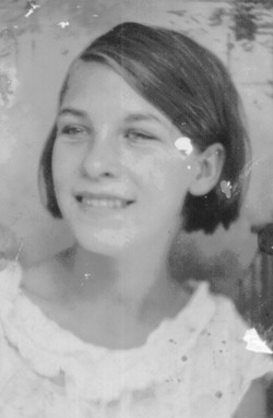
| Birth | : | 14 Jul 1932 |
| Death | : | 3 Jun 2010 |
| Burial | : | Olive Lawn Memorial Park, La Mirada, Los Angeles County, USA |
| Coordinate | : | 33.9038700, -118.0114400 |
| Description | : | "TOGETHER FOREVER" Rest in Peace Aunt Maxine OTTUMWA Edith Maxine Songer, 77, of 802 Ellis Ave., died at 8 a.m. June 3, 2010, at The Good Samaritan Society-Ottumwa. She was born July 14, 1932, in Ottumwa to Maley and Helen Myers Sellwood. She married Teddy M. Songer June 18, 1949, in Ottumwa. He preceded her in death on Feb. 25, 2007. A resident of Ottumwa all of her life, she was a member of Ottumwa Baptist Temple where she taught Sunday school for 22 years as well as sang in the choir. She enjoyed being a housewife and a mother to her twin... Read More |
frequently asked questions (FAQ):
-
Where is Edith Maxine “Aunt Mackie” Sellwood Songer's memorial?
Edith Maxine “Aunt Mackie” Sellwood Songer's memorial is located at: Olive Lawn Memorial Park, La Mirada, Los Angeles County, USA.
-
When did Edith Maxine “Aunt Mackie” Sellwood Songer death?
Edith Maxine “Aunt Mackie” Sellwood Songer death on 3 Jun 2010 in
-
Where are the coordinates of the Edith Maxine “Aunt Mackie” Sellwood Songer's memorial?
Latitude: 33.9038700
Longitude: -118.0114400
Family Members:
Parent
Spouse
Siblings
Children
Flowers:
Nearby Cemetories:
1. Cinco Camp Burial Grounds
Cantil, Kern County, USA
Coordinate: 33.9277710, -118.0649960
2. Norwalk State Hospital Cemetery
Norwalk, Los Angeles County, USA
Coordinate: 33.9277710, -118.0649960
3. Olive Grove Cemetery
Whittier, Los Angeles County, USA
Coordinate: 33.9452300, -118.0511700
4. Little Lake Cemetery
Santa Fe Springs, Los Angeles County, USA
Coordinate: 33.9317900, -118.0779100
5. First Presbyterian Church Memorial Gardens
Fullerton, Orange County, USA
Coordinate: 33.8788600, -117.9417400
6. Saint Josephs Episcopal Church Columbarium
Buena Park, Orange County, USA
Coordinate: 33.8415590, -118.0280360
7. Paradise Memorial Park
Santa Fe Springs, Los Angeles County, USA
Coordinate: 33.9354540, -118.0869900
8. Artesia Cemetery
Cerritos, Los Angeles County, USA
Coordinate: 33.8717003, -118.0958023
9. Loma Vista Memorial Park
Fullerton, Orange County, USA
Coordinate: 33.9016991, -117.9167023
10. Forest Lawn Memorial Park
Cypress, Orange County, USA
Coordinate: 33.8339005, -118.0560989
11. Young Israel Cemetery
Norwalk, Los Angeles County, USA
Coordinate: 33.9071000, -118.1081300
12. Mount Olive Cemetery
Whittier, Los Angeles County, USA
Coordinate: 33.9869003, -118.0453033
13. Broadway Cemetery
Whittier, Los Angeles County, USA
Coordinate: 33.9868088, -118.0460434
14. Saint Andrews Episcopal Church Columbarium
Fullerton, Orange County, USA
Coordinate: 33.8745900, -117.9051200
15. Memory Garden Memorial Park
Brea, Orange County, USA
Coordinate: 33.9336014, -117.9024963
16. Holy Cross Cemetery
Anaheim, Orange County, USA
Coordinate: 33.8236885, -117.9422226
17. Long Beach Police Academy K-9 Cemetery
Long Beach, Los Angeles County, USA
Coordinate: 33.8274000, -118.0895300
18. Saint Marks Episcopal Church Columbarium
Downey, Los Angeles County, USA
Coordinate: 33.9491800, -118.1271200
19. Downey District Cemetery
Downey, Los Angeles County, USA
Coordinate: 33.9102783, -118.1399994
20. Rose Hills Memorial Park
Whittier, Los Angeles County, USA
Coordinate: 34.0139900, -118.0253400
21. Anaheim Cemetery
Anaheim, Orange County, USA
Coordinate: 33.8422012, -117.8981018
22. Queen of Heaven Cemetery
Rowland Heights, Los Angeles County, USA
Coordinate: 33.9818993, -117.9092026
23. El Campo Santo Cemetery
Industry, Los Angeles County, USA
Coordinate: 34.0182300, -117.9630500
24. Magnolia Memorial Park
Garden Grove, Orange County, USA
Coordinate: 33.7843895, -117.9755478


