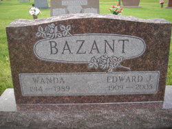
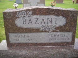
Edward Joseph “Ed” Bazant
| Birth | : | 28 Jun 1909 Garfield County, Nebraska, USA |
| Death | : | 29 Dec 2005 Kearney, Buffalo County, Nebraska, USA |
| Burial | : | McMasters Cemetery, Randolph County, USA |
| Coordinate | : | 35.8072370, -79.6021500 |
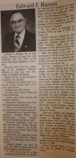
| Description | : | Son of James & Anna (Penas) Bazant. Married to Wanda Grella on 6-4-1934 at Loup City, NE. In 1930, he moved to Loup City, where he was employed as the manager of the Loup City Co-operative Creamery Company. He worked for the Creamery until 1946, when he became the assistant cashier of the First National Bank and the Sherman County Bank of Loup City until his retirement in June 1975. Survivors include a daughter, Shirley Lienert of Nicolaus, Calif.; two grandchildren; two great-granddaughters; and a special friend, Martha Bonczynski of Boelus |
frequently asked questions (FAQ):
-
Where is Edward Joseph “Ed” Bazant's memorial?
Edward Joseph “Ed” Bazant's memorial is located at: McMasters Cemetery, Randolph County, USA.
-
When did Edward Joseph “Ed” Bazant death?
Edward Joseph “Ed” Bazant death on 29 Dec 2005 in Kearney, Buffalo County, Nebraska, USA
-
Where are the coordinates of the Edward Joseph “Ed” Bazant's memorial?
Latitude: 35.8072370
Longitude: -79.6021500
Family Members:
Parent
Spouse
Flowers:
Nearby Cemetories:
1. McMasters Cemetery
Randolph County, USA
Coordinate: 35.8072370, -79.6021500
2. Mount Pleasant Baptist Church Cemetery
Staley, Randolph County, USA
Coordinate: 35.8144700, -79.5790000
3. Hollys Chapel Pentecostal Holiness Church
Ramseur, Randolph County, USA
Coordinate: 35.7825600, -79.6048200
4. Shady Grove Baptist Church Cemetery
Staley, Randolph County, USA
Coordinate: 35.7853800, -79.5821020
5. Margarets Chapel Church Cemetery
Staley, Randolph County, USA
Coordinate: 35.8110940, -79.5648900
6. Lineberry Family Cemetery
Staley, Randolph County, USA
Coordinate: 35.7878000, -79.5724000
7. Old Shady Grove Cemetery
Staley, Randolph County, USA
Coordinate: 35.7874985, -79.5725021
8. Olivers Chapel Cemetery
Staley, Randolph County, USA
Coordinate: 35.8060989, -79.5610962
9. Sandy Creek Primitive Baptist Church Cemetery
Liberty, Randolph County, USA
Coordinate: 35.8239020, -79.6406560
10. Bethany United Methodist Church Cemetery #2
Liberty, Randolph County, USA
Coordinate: 35.8430060, -79.5948160
11. Sandy Creek Baptist Church Cemetery
Liberty, Randolph County, USA
Coordinate: 35.8235550, -79.6429050
12. Whites Chapel United Methodist Church Cemetery
Liberty, Randolph County, USA
Coordinate: 35.7850520, -79.6422990
13. Staley City Cemetery
Staley, Randolph County, USA
Coordinate: 35.7918300, -79.5507100
14. York Family Cemetery
Ramseur, Randolph County, USA
Coordinate: 35.7603000, -79.6108000
15. Amos Grove Cemetery
Liberty, Randolph County, USA
Coordinate: 35.8546982, -79.5871964
16. Fairview Cemetery
Liberty, Randolph County, USA
Coordinate: 35.8516998, -79.5761032
17. Saint Stephen Memorial Gardens
Liberty, Randolph County, USA
Coordinate: 35.8550750, -79.5877970
18. Melanchthon Lutheran Church Cemetery
Liberty, Randolph County, USA
Coordinate: 35.8451630, -79.6440640
19. Patterson Grove Christian Church Cemetery
Ramseur, Randolph County, USA
Coordinate: 35.7743940, -79.6536550
20. Bible Truth Church Cemetery
Ramseur, Randolph County, USA
Coordinate: 35.7485370, -79.6204580
21. Cool Springs Baptist Church Cemetery
Franklinville, Randolph County, USA
Coordinate: 35.8072420, -79.6805660
22. Friendship AME Church Cemetery
Ramseur, Randolph County, USA
Coordinate: 35.7463280, -79.6437970
23. Liberty Grove Methodist Church Cemetery
Liberty, Randolph County, USA
Coordinate: 35.8733140, -79.5709950
24. Marley Cemetery
Chatham County, USA
Coordinate: 35.7522011, -79.5430984


