
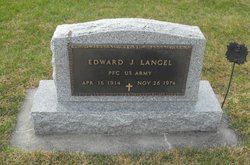
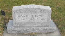
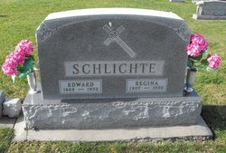
Edward Joseph Langel
| Birth | : | 16 Apr 1914 Templeton, Carroll County, Iowa, USA |
| Death | : | 26 Nov 1974 Rochester, Olmsted County, Minnesota, USA |
| Burial | : | Sacred Heart Cemetery, Templeton, Carroll County, USA |
| Coordinate | : | 41.9138746, -94.9460994 |
| Description | : | From the November 27, 1974, of the Carroll (IA) Times Herald Edward J. Langel TEMPLETON -- Mass of the resurrection for Edward J. Langel, 60, of Templeton will be celebrated at 1:30 pm Friday in Sacred Heart Church here by the Rev. Eugene T. Schumacher. Interment will be in the parish cemetery, with military rites by the Emil Ewoldt American Legion Post No. 22 and V.F.W. Post No. 3517 of Manning. Friends may call after 2:30 pm Thursday at the Twit Funeral Home in Carroll. There will be a rosary Thursday at 3 pm, followed by a prayer service at 8... Read More |
frequently asked questions (FAQ):
-
Where is Edward Joseph Langel's memorial?
Edward Joseph Langel's memorial is located at: Sacred Heart Cemetery, Templeton, Carroll County, USA.
-
When did Edward Joseph Langel death?
Edward Joseph Langel death on 26 Nov 1974 in Rochester, Olmsted County, Minnesota, USA
-
Where are the coordinates of the Edward Joseph Langel's memorial?
Latitude: 41.9138746
Longitude: -94.9460994
Family Members:
Parent

Siblings

Flowers:


Nearby Cemetories:
1. Sacred Heart Cemetery
Templeton, Carroll County, USA
Coordinate: 41.9138746, -94.9460994
2. Elba Cemetery
Templeton, Carroll County, USA
Coordinate: 41.9068985, -94.9131012
3. Sacred Heart Cemetery
Manning, Carroll County, USA
Coordinate: 41.9132500, -95.0540000
4. Gray Cemetery
Gray, Audubon County, USA
Coordinate: 41.8414001, -94.9946976
5. Manning Cemetery
Manning, Carroll County, USA
Coordinate: 41.8990000, -95.0620000
6. Holy Angels Cemetery
Carroll County, USA
Coordinate: 42.0014000, -94.9141998
7. Cameron Cemetery
Audubon County, USA
Coordinate: 41.8236008, -94.9167023
8. Dedham Cemetery
Dedham, Carroll County, USA
Coordinate: 41.8993988, -94.8225021
9. Saint Josephs Cemetery
Dedham, Carroll County, USA
Coordinate: 41.8993988, -94.8210983
10. Saint Augustine Cemetery
Halbur, Carroll County, USA
Coordinate: 42.0066986, -94.9744034
11. Lincoln Township Cemetery
Gray, Audubon County, USA
Coordinate: 41.8198130, -95.0154970
12. Saint Marys Catholic Cemetery
Willey, Carroll County, USA
Coordinate: 41.9783363, -94.8212204
13. Iowa Township Cemetery
Aspinwall, Crawford County, USA
Coordinate: 41.9216995, -95.1113968
14. McCurdy Cemetery
Carroll County, USA
Coordinate: 41.9403000, -94.7649994
15. Viola Center Cemetery
Viola Center, Audubon County, USA
Coordinate: 41.8236008, -94.8016968
16. Old Carrollton Cemetery
Carrollton, Carroll County, USA
Coordinate: 41.9233017, -94.7403030
17. Mount Olivet Cemetery
Carroll, Carroll County, USA
Coordinate: 42.0536340, -94.8595510
18. Carroll City Cemetery
Carroll, Carroll County, USA
Coordinate: 42.0560963, -94.8599856
19. Hayes Township Cemetery
Westside, Crawford County, USA
Coordinate: 42.0083199, -95.1216583
20. Luccocks Grove Cemetery
Audubon County, USA
Coordinate: 41.7619019, -94.8653030
21. Douglas Township Cemetery
Audubon County, USA
Coordinate: 41.7611008, -95.0282974
22. Oak Hill Cemetery
Coon Rapids, Carroll County, USA
Coordinate: 41.9053001, -94.7200012
23. Westside Cemetery
Westside, Crawford County, USA
Coordinate: 42.0602989, -95.0922012
24. Saint Francis Cemetery
Maple River, Carroll County, USA
Coordinate: 42.0969009, -94.9372025