
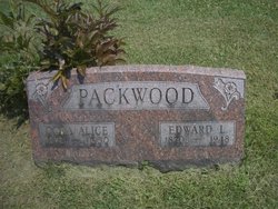
Edward Lee Packwood
| Birth | : | 15 May 1869 Wapello County, Iowa, USA |
| Death | : | 30 Oct 1948 Wapello County, Iowa, USA |
| Burial | : | Mount Horeb Cemetery, Slater, Saline County, USA |
| Coordinate | : | 39.2111015, -93.1177979 |
| Plot | : | Lot #33 |
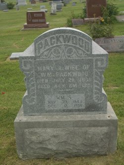
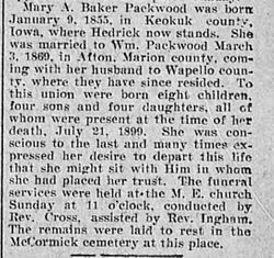
| Description | : | Son of William Samuel Packwood & Mary Alice Baker Birth Book 4 1899-1911 has 3 children born; ? Dec 6, 1902, Max Oct 2, 1910 *Wanda April 15, 1899; married Ralph Ellis March 31, 1914. Dora Knight Packwood 10357645 Married 1893 Birth book 2 1918-1921 Forrest Lee Packwood July 20, 1918; parents Edward L. Packwood & Dora Alice Knight Birth book 3 1891-1889 Edna Loraine June 4, 1895 * Kenneth George Feb 22, 1894 married at age 22 to Jessie C. Crow age 20 June 27, 1915. Bride's parents; Frank Crow & Clara West. *Marriages book 25 Delayed Births L - Z Bernice Nov 24, 1908 Wanda Apr 15, 1898 |
frequently asked questions (FAQ):
-
Where is Edward Lee Packwood's memorial?
Edward Lee Packwood's memorial is located at: Mount Horeb Cemetery, Slater, Saline County, USA.
-
When did Edward Lee Packwood death?
Edward Lee Packwood death on 30 Oct 1948 in Wapello County, Iowa, USA
-
Where are the coordinates of the Edward Lee Packwood's memorial?
Latitude: 39.2111015
Longitude: -93.1177979
Family Members:
Parent
Spouse

Siblings
Children
Flowers:


Nearby Cemetories:
1. Hickman Cemetery
Saline County, USA
Coordinate: 39.2111015, -93.1177979
2. Mount Horeb Cemetery
Slater, Saline County, USA
Coordinate: 39.2111015, -93.1177979
3. Hyland Cemetery
Norton, Saline County, USA
Coordinate: 39.2024640, -93.1584430
4. Pulliam-Hedges-Swisher Cemetery
Marshall, Saline County, USA
Coordinate: 39.1839210, -93.1417940
5. Rehoboth Cemetery
Slater, Saline County, USA
Coordinate: 39.2323300, -93.0666200
6. Mount Moriah Cemetery
Slater, Saline County, USA
Coordinate: 39.2335900, -93.0664100
7. Orearville Cemetery
Orearville, Saline County, USA
Coordinate: 39.1724840, -93.0750080
8. Slater City Cemetery
Slater, Saline County, USA
Coordinate: 39.2308273, -93.0570755
9. Orear Family Cemetery
Orearville, Saline County, USA
Coordinate: 39.1701550, -93.0756410
10. Cow Creek Cemetery
Fairville, Saline County, USA
Coordinate: 39.2182900, -93.1907340
11. Dawes Durrett Cemetery
Orearville, Saline County, USA
Coordinate: 39.1591580, -93.0819650
12. Fairville Cemetery
Fairville, Saline County, USA
Coordinate: 39.2317400, -93.2047900
13. Saline County Poor Farm Cemetery
Marshall, Saline County, USA
Coordinate: 39.1524730, -93.1811930
14. Mount Carmel Cemetery
Fairville, Saline County, USA
Coordinate: 39.2099650, -93.2229850
15. Wolfskill Cemetery
Saline County, USA
Coordinate: 39.2889167, -93.0845000
16. Missouri State School Cemetery
Marshall, Saline County, USA
Coordinate: 39.1341900, -93.1794600
17. Odell Cemetery
Marshall, Saline County, USA
Coordinate: 39.1352997, -93.1838989
18. Bethel Cemetery
Sharon, Saline County, USA
Coordinate: 39.3025600, -93.1349300
19. Old Catholic Cemetery
Marshall, Saline County, USA
Coordinate: 39.1315700, -93.1846700
20. Shiloh Methodist Church Cemetery
Marshall, Saline County, USA
Coordinate: 39.1148470, -93.0957760
21. Harris Cemetery
Slater, Saline County, USA
Coordinate: 39.3098010, -93.0944170
22. Gilliam Cemetery
Gilliam, Saline County, USA
Coordinate: 39.2352982, -92.9906006
23. High Hill Cemetery
Gilliam, Saline County, USA
Coordinate: 39.3046989, -93.0569000
24. Fairview Cemetery
Marshall, Saline County, USA
Coordinate: 39.1171989, -93.1793976