
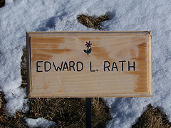
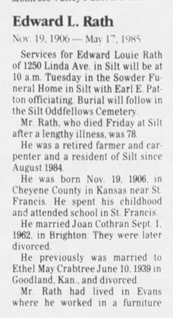


Edward Louie Rath
| Birth | : | 19 Nov 1906 Saint Francis, Cheyenne County, Kansas, USA |
| Death | : | 17 May 1985 Silt, Garfield County, Colorado, USA |
| Burial | : | Skyline Cemetery, Silt, Garfield County, USA |
| Coordinate | : | 39.5520060, -107.6575300 |
| Plot | : | E-28 |
| Description | : | An obituary appears in the Rifle Telegram on May 22, 1985 P:6 |
frequently asked questions (FAQ):
-
Where is Edward Louie Rath's memorial?
Edward Louie Rath's memorial is located at: Skyline Cemetery, Silt, Garfield County, USA.
-
When did Edward Louie Rath death?
Edward Louie Rath death on 17 May 1985 in Silt, Garfield County, Colorado, USA
-
Where are the coordinates of the Edward Louie Rath's memorial?
Latitude: 39.5520060
Longitude: -107.6575300
Family Members:
Parent

Spouse
Siblings

Flowers:


Nearby Cemetories:
1. Skyline Cemetery
Silt, Garfield County, USA
Coordinate: 39.5520060, -107.6575300
2. Rose Hill Cemetery
Rifle, Garfield County, USA
Coordinate: 39.5381012, -107.7742004
3. Union Divide Creek Cemetery
Silt, Garfield County, USA
Coordinate: 39.4508018, -107.6200027
4. Highland Cemetery
New Castle, Garfield County, USA
Coordinate: 39.5875015, -107.5192032
5. Rulison Cemetery
Rulison, Garfield County, USA
Coordinate: 39.4768000, -107.9357000
6. Farnum Holt Columbarium
Glenwood Springs, Garfield County, USA
Coordinate: 39.5469640, -107.3299900
7. Pioneer Cemetery
Glenwood Springs, Garfield County, USA
Coordinate: 39.5392000, -107.3192000
8. Rosebud Cemetery
Glenwood Springs, Garfield County, USA
Coordinate: 39.5168991, -107.3189011
9. Battlement Cemetery
Parachute, Garfield County, USA
Coordinate: 39.4380989, -108.0291977
10. Russey-Hurlburt Cemetery
Parachute, Garfield County, USA
Coordinate: 39.4522018, -108.0575027
11. Blackman Ranch Cemetery
Collbran, Mesa County, USA
Coordinate: 39.2647420, -107.8554350
12. Marion Cemetery
Garfield County, USA
Coordinate: 39.3689003, -107.3047028
13. Clover Cemetery
Collbran, Mesa County, USA
Coordinate: 39.2550011, -107.9227982
14. Fisher Cemetery
Carbondale, Garfield County, USA
Coordinate: 39.4791985, -107.1911011
15. Evergreen Cemetery
Carbondale, Garfield County, USA
Coordinate: 39.4077988, -107.2155991
16. Cedar Crest Cemetery
Collbran, Mesa County, USA
Coordinate: 39.2369003, -107.9589005
17. Hillcrest Cemetery
Carbondale, Garfield County, USA
Coordinate: 39.3922005, -107.1936035
18. Eagalite Cemetery
Plateau City, Mesa County, USA
Coordinate: 39.2228012, -107.9894028
19. Dotsero Cemetery
Dotsero, Eagle County, USA
Coordinate: 39.6477600, -107.0672200
20. Molina Cemetery
Molina, Mesa County, USA
Coordinate: 39.1886000, -108.0629000
21. DeBeque Cemetery
Mesa County, USA
Coordinate: 39.3374060, -108.2138900
22. Hillside Cemetery
Redstone, Pitkin County, USA
Coordinate: 39.1843300, -107.2418900
23. Highland Cemetery
Meeker, Rio Blanco County, USA
Coordinate: 40.0311012, -107.9111023
24. Mesa Cemetery
Mesa, Mesa County, USA
Coordinate: 39.1685982, -108.1188965