

Edward McConnell Drais
| Birth | : | 17 Feb 1842 Missouri, USA |
| Death | : | 6 Apr 1918 Farmington, San Joaquin County, California, USA |
| Burial | : | Highland View Memorial Gardens, Farmington, San Joaquin County, USA |
| Coordinate | : | 37.9242935, -121.0008621 |
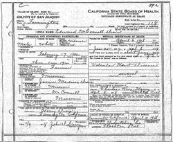
| Description | : | Per his death certificate, Edward McDonnell Drais died on 6 Apr 1918 in Farmington, San Joaquin County, CA. He was under the care of Dr. Charles Rees Harry of Stockton from 25 Jan 1917 to about Jun 1917. Dr. Harry determined he died of "Valvular Heart Disease," a condition he suffered from for several years. Thereafter, the deceased was buried in the Farmington Cemetery on 9 Apr 1918, with the firm of Wallace Undertaking Company of Stockton taking care of the funeral arrangements. Henry Drais was the informant for the personal information in the death certificate.... Read More |
frequently asked questions (FAQ):
-
Where is Edward McConnell Drais's memorial?
Edward McConnell Drais's memorial is located at: Highland View Memorial Gardens, Farmington, San Joaquin County, USA.
-
When did Edward McConnell Drais death?
Edward McConnell Drais death on 6 Apr 1918 in Farmington, San Joaquin County, California, USA
-
Where are the coordinates of the Edward McConnell Drais's memorial?
Latitude: 37.9242935
Longitude: -121.0008621
Family Members:
Parent
Spouse

Siblings

Children

Flowers:


Nearby Cemetories:
1. Highland View Memorial Gardens
Farmington, San Joaquin County, USA
Coordinate: 37.9242935, -121.0008621
2. Old Brooks Farm Cemetery
Farmington, San Joaquin County, USA
Coordinate: 37.9175800, -120.9440300
3. Saint Joseph Cemetery
Eugene, Stanislaus County, USA
Coordinate: 37.8941994, -120.8696976
4. Valley Home Memorial Park
Oakdale, Stanislaus County, USA
Coordinate: 37.8275528, -120.9333267
5. Collegeville Cemetery
Collegeville, San Joaquin County, USA
Coordinate: 37.9044800, -121.1466141
6. Linden Cemetery
Linden, San Joaquin County, USA
Coordinate: 38.0226707, -121.0889053
7. Saint John's Catholic Cemetery
Escalon, San Joaquin County, USA
Coordinate: 37.7994537, -121.0705185
8. Atlanta Cemetery
Five Corners, San Joaquin County, USA
Coordinate: 37.8270035, -121.1420135
9. Milton Masonic Cemetery
Milton, Calaveras County, USA
Coordinate: 38.0308189, -120.8498230
10. Kirk Family Cemetery
Linden, San Joaquin County, USA
Coordinate: 38.0799700, -120.9508900
11. Burwood Cemetery
Escalon, San Joaquin County, USA
Coordinate: 37.7616997, -120.9593964
12. Langworth Cemetery
Oakdale, Stanislaus County, USA
Coordinate: 37.7580986, -120.8957977
13. Park View Cemetery
Manteca, San Joaquin County, USA
Coordinate: 37.8617249, -121.2238312
14. Oaklawn Memorial Park
Oakdale, Stanislaus County, USA
Coordinate: 37.7711945, -120.8486862
15. Jenny Lind IOOF Cemetery
Jenny Lind, Calaveras County, USA
Coordinate: 38.0990880, -120.8716360
16. Oakdale Citizens Cemetery
Oakdale, Stanislaus County, USA
Coordinate: 37.7624600, -120.8388800
17. Ripon Cemetery
Ripon, San Joaquin County, USA
Coordinate: 37.7420311, -121.1238708
18. Telegraph City Cemetery
Telegraph City, Calaveras County, USA
Coordinate: 37.9290460, -120.7302490
19. East Union Cemetery
Manteca, San Joaquin County, USA
Coordinate: 37.8114014, -121.2350006
20. Beardslee Family Cemetery
Telegraph City, Calaveras County, USA
Coordinate: 37.9423190, -120.7265960
21. Citizens Cemetery
Stockton, San Joaquin County, USA
Coordinate: 37.9559410, -121.2769120
22. Congregation Adas Yeshuran of Stockton Cemetery
French Camp, San Joaquin County, USA
Coordinate: 37.8784065, -121.2740784
23. Congregation of Ahavas Achim Cemetery
French Camp, San Joaquin County, USA
Coordinate: 37.8778419, -121.2753067
24. Dean Family Cemetery
Copperopolis, Calaveras County, USA
Coordinate: 38.0575050, -120.7747760