
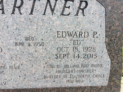
Edward Paul “Ed” Hartner
| Birth | : | 18 Oct 1928 Clay Center, Clay County, Kansas, USA |
| Death | : | 14 Sep 2015 Kansas, USA |
| Burial | : | Green Cemetery, Green, Clay County, USA |
| Coordinate | : | 39.4235992, -96.9882965 |
| Description | : | Edward Paul Ed Hartner Edward Paul Ed Hartner, 86, Topeka, passed away Monday, September 14, 2015. He was born October 18, 1928, in Clay Center, Kansas, to William and Minnie (Burger) Hartner. Ed graduated from Clay Center High School in 1947 and lived on the farm until 1950. On March 11, 1950, he married Betty Lang of Green, Kansas, in the Lang family farmhouse and they moved to a farm southwest of Clay Center. Ed received his military draft notice in 1951 and enlisted in the United States Air Force. He served four years in the Air Force and in... Read More |
frequently asked questions (FAQ):
-
Where is Edward Paul “Ed” Hartner's memorial?
Edward Paul “Ed” Hartner's memorial is located at: Green Cemetery, Green, Clay County, USA.
-
When did Edward Paul “Ed” Hartner death?
Edward Paul “Ed” Hartner death on 14 Sep 2015 in Kansas, USA
-
Where are the coordinates of the Edward Paul “Ed” Hartner's memorial?
Latitude: 39.4235992
Longitude: -96.9882965
Family Members:
Parent

Siblings
Flowers:


Nearby Cemetories:
1. Green Cemetery
Green, Clay County, USA
Coordinate: 39.4235992, -96.9882965
2. Ebenezer Cemetery
Green, Clay County, USA
Coordinate: 39.3866997, -96.9974976
3. Pleasant Hill Cemetery
Leonardville, Riley County, USA
Coordinate: 39.4371210, -96.9426730
4. Lasita Cemetery
Leonardville, Riley County, USA
Coordinate: 39.4092900, -96.9422900
5. Fancy Creek Cemetery
Green, Clay County, USA
Coordinate: 39.4668999, -96.9969025
6. Brethren in Christ Cemetery
Clay County, USA
Coordinate: 39.4810982, -97.0344009
7. Hayes Cemetery
Clay County, USA
Coordinate: 39.4516983, -97.0811005
8. Clay County Poor Farm Cemetery
Clay Center, Clay County, USA
Coordinate: 39.3772700, -97.0727000
9. May Day Cemetery
Center Township, Riley County, USA
Coordinate: 39.4958000, -96.9302979
10. Goshen Central Cemetery
Clay Center, Clay County, USA
Coordinate: 39.5099983, -97.0160980
11. Joseph Sender Family Cemetery
Clay County, USA
Coordinate: 39.5090600, -97.0348800
12. Appleton Cemetery
Clay County, USA
Coordinate: 39.5250015, -96.9972000
13. Broughton Cemetery
Clay Center, Clay County, USA
Coordinate: 39.3306007, -97.0535965
14. Saint Peter and Saint Pauls Catholic Cemetery
Clay Center, Clay County, USA
Coordinate: 39.4005450, -97.1236680
15. Idylwilde Cemetery
Clay Center, Clay County, USA
Coordinate: 39.5097900, -97.0713000
16. Crooked Creek Cemetery
Randolph, Riley County, USA
Coordinate: 39.4369011, -96.8480988
17. Leonardville Cemetery
Leonardville, Riley County, USA
Coordinate: 39.3792000, -96.8589020
18. Greenwood Cemetery
Clay Center, Clay County, USA
Coordinate: 39.4011002, -97.1275024
19. Swedish Pleasant Hill Cemetery
Clay Center, Clay County, USA
Coordinate: 39.4735985, -97.1268997
20. Saint Johns Lutheran Cemetery
Winkler, Riley County, USA
Coordinate: 39.4813995, -96.8494034
21. Bala Cemetery
Bala, Riley County, USA
Coordinate: 39.3053017, -96.9341965
22. Leonardville United Methodist Cemetery
Leonardville, Riley County, USA
Coordinate: 39.3568700, -96.8493600
23. Walsburg Lutheran Cemetery
Leonardville, Riley County, USA
Coordinate: 39.3931100, -96.8133200
24. Swedish Evangelical Lutheran Cemetery
Clay County, USA
Coordinate: 39.4911700, -97.1455100