
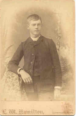

Edwin Charles Allen
| Birth | : | 26 Jan 1871 Eudora, Douglas County, Kansas, USA |
| Death | : | 6 Sep 1933 Dunnegan, Polk County, Missouri, USA |
| Burial | : | Vinland Cemetery, Vinland, Douglas County, USA |
| Coordinate | : | 38.8485985, -95.1763992 |
| Description | : | He worked in a buggy whip factory when he was young. He married Alice 'Allie' Elizabeth Scates who also has a cyber grave here. They had six children of their own and raised one grandson. Those who remember him say he was very soft spoken, hard working, intelligent and an incessant reader. |
frequently asked questions (FAQ):
-
Where is Edwin Charles Allen's memorial?
Edwin Charles Allen's memorial is located at: Vinland Cemetery, Vinland, Douglas County, USA.
-
When did Edwin Charles Allen death?
Edwin Charles Allen death on 6 Sep 1933 in Dunnegan, Polk County, Missouri, USA
-
Where are the coordinates of the Edwin Charles Allen's memorial?
Latitude: 38.8485985
Longitude: -95.1763992
Family Members:
Parent
Spouse
Siblings
Children

Flowers:


Nearby Cemetories:
1. Stony Point Cemetery
Vinland, Douglas County, USA
Coordinate: 38.8249512, -95.2107391
2. Dow Cemetery
Vinland, Douglas County, USA
Coordinate: 38.8186620, -95.2143000
3. Brumbaugh Cemetery
Douglas County, USA
Coordinate: 38.8319200, -95.2330100
4. Breeze Family Cemetery
Pleasant Grove, Douglas County, USA
Coordinate: 38.8472800, -95.2480400
5. Blue Mound Cemetery
Lawrence, Douglas County, USA
Coordinate: 38.9046600, -95.1865400
6. Ulrich Cemetery
Pleasant Grove, Douglas County, USA
Coordinate: 38.8395740, -95.2531810
7. Clearfield Cemetery
Clearfield, Douglas County, USA
Coordinate: 38.8260002, -95.0930023
8. County Poor Farm Cemetery
Douglas County, USA
Coordinate: 38.9119400, -95.2214600
9. Richland Cemetery
Lawrence, Douglas County, USA
Coordinate: 38.8768997, -95.2630997
10. Kennedy Cemetery
Douglas County, USA
Coordinate: 38.9112900, -95.2269200
11. Marshall Cemetery
Douglas County, USA
Coordinate: 38.9040800, -95.2446700
12. Deay Cemetery
Eudora, Douglas County, USA
Coordinate: 38.8546486, -95.0749435
13. Oakwood Cemetery
Baldwin City, Douglas County, USA
Coordinate: 38.7694016, -95.1825027
14. Pleasant Hill Cemetery
Pleasant Grove, Douglas County, USA
Coordinate: 38.8535995, -95.2794037
15. Prairie City Cemetery
Baldwin City, Douglas County, USA
Coordinate: 38.7689018, -95.2050018
16. Mount Calvary Cemetery
Baldwin City, Douglas County, USA
Coordinate: 38.7687988, -95.2049713
17. Miller Family Cemetery
Baldwin City, Douglas County, USA
Coordinate: 38.7688751, -95.2146683
18. Baldwin City Cemetery
Baldwin City, Douglas County, USA
Coordinate: 38.7612953, -95.1862869
19. Cemetery Beni Israel
Eudora, Douglas County, USA
Coordinate: 38.9280128, -95.1122208
20. Dutton Cemetery
Douglas County, USA
Coordinate: 38.8989800, -95.2790600
21. Black Jack Cemetery
Douglas County, USA
Coordinate: 38.7660400, -95.1159400
22. Franklin Cemetery
Douglas County, USA
Coordinate: 38.9437523, -95.1869431
23. Haskell Cemetery
Lawrence, Douglas County, USA
Coordinate: 38.9353790, -95.2284241
24. Saint Johns Catholic Cemetery
Douglas County, USA
Coordinate: 38.9437900, -95.1919600