
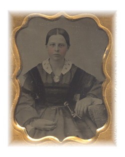
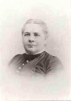
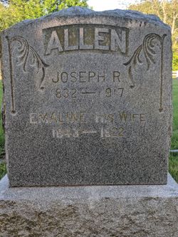
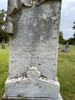
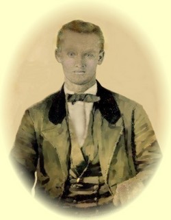
Emmaline Pearson Allen
| Birth | : | 12 Nov 1843 Fort Wayne, Allen County, Indiana, USA |
| Death | : | Jan 1923 Lawrence, Douglas County, Kansas, USA |
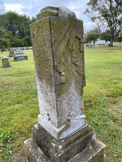
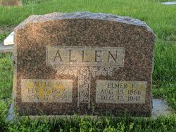
| Burial | : | Vinland Cemetery, Vinland, Douglas County, USA |
| Coordinate | : | 38.8485985, -95.1763992 |
| Description | : | Emaline came from an abolitionist family. She was the daughter of Thomas Pearson Sr. and his second wife Rhoda Rogers. She married very young, she was only 13 years old! Her husband was 11 years her senior, 24 years old. She married Joseph Richardson Allen (who has a cyber grave here) on 22 May 1857 at Newton, Jasper Co, IA. They moved to Lawrence, Kansas in support of the anti-slave vote there and were living at Lawrence during the famous Quantrill raid on that city. They had 7 children: 1.) Sarah Jane who changed her name to Jennie S.,born 1858... Read More |
frequently asked questions (FAQ):
-
Where is Emmaline Pearson Allen's memorial?
Emmaline Pearson Allen's memorial is located at: Vinland Cemetery, Vinland, Douglas County, USA.
-
When did Emmaline Pearson Allen death?
Emmaline Pearson Allen death on Jan 1923 in Lawrence, Douglas County, Kansas, USA
-
Where are the coordinates of the Emmaline Pearson Allen's memorial?
Latitude: 38.8485985
Longitude: -95.1763992
Family Members:
Parent
Spouse
Siblings
Children
Flowers:


Nearby Cemetories:
1. Stony Point Cemetery
Vinland, Douglas County, USA
Coordinate: 38.8249512, -95.2107391
2. Dow Cemetery
Vinland, Douglas County, USA
Coordinate: 38.8186620, -95.2143000
3. Brumbaugh Cemetery
Douglas County, USA
Coordinate: 38.8319200, -95.2330100
4. Breeze Family Cemetery
Pleasant Grove, Douglas County, USA
Coordinate: 38.8472800, -95.2480400
5. Blue Mound Cemetery
Lawrence, Douglas County, USA
Coordinate: 38.9046600, -95.1865400
6. Ulrich Cemetery
Pleasant Grove, Douglas County, USA
Coordinate: 38.8395740, -95.2531810
7. Clearfield Cemetery
Clearfield, Douglas County, USA
Coordinate: 38.8260002, -95.0930023
8. County Poor Farm Cemetery
Douglas County, USA
Coordinate: 38.9119400, -95.2214600
9. Richland Cemetery
Lawrence, Douglas County, USA
Coordinate: 38.8768997, -95.2630997
10. Kennedy Cemetery
Douglas County, USA
Coordinate: 38.9112900, -95.2269200
11. Marshall Cemetery
Douglas County, USA
Coordinate: 38.9040800, -95.2446700
12. Deay Cemetery
Eudora, Douglas County, USA
Coordinate: 38.8546486, -95.0749435
13. Oakwood Cemetery
Baldwin City, Douglas County, USA
Coordinate: 38.7694016, -95.1825027
14. Pleasant Hill Cemetery
Pleasant Grove, Douglas County, USA
Coordinate: 38.8535995, -95.2794037
15. Prairie City Cemetery
Baldwin City, Douglas County, USA
Coordinate: 38.7689018, -95.2050018
16. Mount Calvary Cemetery
Baldwin City, Douglas County, USA
Coordinate: 38.7687988, -95.2049713
17. Miller Family Cemetery
Baldwin City, Douglas County, USA
Coordinate: 38.7688751, -95.2146683
18. Baldwin City Cemetery
Baldwin City, Douglas County, USA
Coordinate: 38.7612953, -95.1862869
19. Cemetery Beni Israel
Eudora, Douglas County, USA
Coordinate: 38.9280128, -95.1122208
20. Dutton Cemetery
Douglas County, USA
Coordinate: 38.8989800, -95.2790600
21. Black Jack Cemetery
Douglas County, USA
Coordinate: 38.7660400, -95.1159400
22. Franklin Cemetery
Douglas County, USA
Coordinate: 38.9437523, -95.1869431
23. Haskell Cemetery
Lawrence, Douglas County, USA
Coordinate: 38.9353790, -95.2284241
24. Saint Johns Catholic Cemetery
Douglas County, USA
Coordinate: 38.9437900, -95.1919600