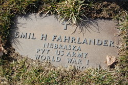
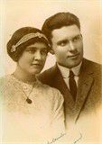
| Birth | : | 11 Sep 1896 Mills, Mills County, Iowa, USA |
| Death | : | 7 Mar 1932 Brule, Keith County, Nebraska, USA |
| Burial | : | Mount Calvary Cemetery, De Pere, Brown County, USA |
| Coordinate | : | 44.4572144, -88.0992661 |
| Description | : | Nebr Pvt SATC Kansas State Agri College ------------------------- Edwin Herman Fahrlander, son of Herman Fahrlander and Maria Elizabeth Gosch was born on 11 Sep 1896 in Mills, Iowa, USA. He died on 07 Mar 1932 in Brule, Keith, Nebraska, USA. He married Edith Emma Frans in Union, Butler, Nebraska, USA. She was born in 1894. She died in 1984. From Find A Grave contributor Barbara A ------------------------- |
frequently asked questions (FAQ):
-
Where is Edwin Herman Fahrlander's memorial?
Edwin Herman Fahrlander's memorial is located at: Mount Calvary Cemetery, De Pere, Brown County, USA.
-
When did Edwin Herman Fahrlander death?
Edwin Herman Fahrlander death on 7 Mar 1932 in Brule, Keith County, Nebraska, USA
-
Where are the coordinates of the Edwin Herman Fahrlander's memorial?
Latitude: 44.4572144
Longitude: -88.0992661
Family Members:
Parent
Spouse
Siblings
Children
Flowers:
Nearby Cemetories:
1. Mount Calvary Cemetery
De Pere, Brown County, USA
Coordinate: 44.4572144, -88.0992661
2. Cady Cemetery
De Pere, Brown County, USA
Coordinate: 44.4346800, -88.1198100
3. De Pere Greenwood Cemetery
De Pere, Brown County, USA
Coordinate: 44.4308014, -88.0693970
4. Ashwaubenon Moravian Cemetery
Green Bay, Brown County, USA
Coordinate: 44.4930110, -88.0984300
5. Mount Olivet Catholic Cemetery
De Pere, Brown County, USA
Coordinate: 44.4392014, -88.0543976
6. Saint Norbert Abbey Cemetery
De Pere, Brown County, USA
Coordinate: 44.4573300, -88.0465100
7. Saint Annes Memorial Garden
De Pere, Brown County, USA
Coordinate: 44.4401100, -88.0370000
8. Saint Johns Lutheran Cemetery of Ashwaubenon
Green Bay, Brown County, USA
Coordinate: 44.5033610, -88.1191380
9. Allouez Catholic Cemetery And Chapel Mausoleum
Green Bay, Brown County, USA
Coordinate: 44.4824982, -88.0263977
10. Oneida Sacred Burial Grounds
Oneida, Brown County, USA
Coordinate: 44.4724400, -88.1811600
11. Saint Michaels Cemetery
De Pere, Brown County, USA
Coordinate: 44.3968000, -88.1197000
12. Woodlawn Cemetery
Green Bay, Brown County, USA
Coordinate: 44.4902992, -88.0175018
13. Bristol Cemetery
De Pere, Brown County, USA
Coordinate: 44.4149430, -88.0215805
14. Holy Apostles Church Cemetery
Oneida, Brown County, USA
Coordinate: 44.4945984, -88.1825027
15. Union Congregational Church Memorial Garden
Green Bay, Brown County, USA
Coordinate: 44.5045890, -88.0184980
16. La Baye Burial Place
Green Bay, Brown County, USA
Coordinate: 44.5095370, -88.0176650
17. Zion Lutheran Cemetery
Oneida, Brown County, USA
Coordinate: 44.5175018, -88.1716995
18. Garden of Grace
Green Bay, Brown County, USA
Coordinate: 44.5096300, -88.0139260
19. Latter Day Saints Cemetery
Chicago Corners, Outagamie County, USA
Coordinate: 44.5038030, -88.1913670
20. Saint Joseph Cemetery
Chicago Corners, Outagamie County, USA
Coordinate: 44.4850006, -88.2082977
21. Saint Francis Xavier Roman Catholic Cathedral
Green Bay, Brown County, USA
Coordinate: 44.5112376, -88.0113732
22. United Methodist Cemetery
Oneida, Outagamie County, USA
Coordinate: 44.4553900, -88.2181600
23. Church of Christ Cemetery
Chicago Corners, Outagamie County, USA
Coordinate: 44.4441986, -88.2230988
24. Oneida Assembly of God Cemetery
Oneida, Outagamie County, USA
Coordinate: 44.5035400, -88.2109900


