
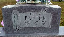
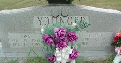
Effie Violetta Younger Barton
| Birth | : | 20 Apr 1905 Alley, Shannon County, Missouri, USA |
| Death | : | 24 Jul 1975 Saint John, St. Louis County, Missouri, USA |
| Burial | : | Blackley Cemetery and Crematorium, Blackley, Metropolitan Borough of Manchester, England |
| Coordinate | : | 53.5333176, -2.2394190 |
| Inscription | : | Mother. |
frequently asked questions (FAQ):
-
Where is Effie Violetta Younger Barton's memorial?
Effie Violetta Younger Barton's memorial is located at: Blackley Cemetery and Crematorium, Blackley, Metropolitan Borough of Manchester, England.
-
When did Effie Violetta Younger Barton death?
Effie Violetta Younger Barton death on 24 Jul 1975 in Saint John, St. Louis County, Missouri, USA
-
Where are the coordinates of the Effie Violetta Younger Barton's memorial?
Latitude: 53.5333176
Longitude: -2.2394190
Family Members:
Parent
Spouse
Siblings
Children


Nearby Cemetories:
1. Blackley Cemetery and Crematorium
Blackley, Metropolitan Borough of Manchester, England
Coordinate: 53.5333176, -2.2394190
2. All Saints Churchyard Rhodes
Middleton, Metropolitan Borough of Rochdale, England
Coordinate: 53.5437200, -2.2261400
3. Blackley Presbyterian Chapel Chapelyard
Blackley, Metropolitan Borough of Manchester, England
Coordinate: 53.5233100, -2.2248110
4. St. Peter's Churchyard
Blackley, Metropolitan Borough of Manchester, England
Coordinate: 53.5231200, -2.2188900
5. Blackley Jewish Cemetery
Blackley, Metropolitan Borough of Manchester, England
Coordinate: 53.5299377, -2.2097650
6. Wesleyan Methodist Cemetery
Crumpsall, Metropolitan Borough of Manchester, England
Coordinate: 53.5142870, -2.2447610
7. Crumpsall Jewish Cemetery
Crumpsall, Metropolitan Borough of Manchester, England
Coordinate: 53.5124250, -2.2280270
8. St. Marks' Churchyard
Cheetham Hill, Metropolitan Borough of Manchester, England
Coordinate: 53.5113780, -2.2462660
9. Christchurch Harpurhey Churchyard
Harpurhey, Metropolitan Borough of Manchester, England
Coordinate: 53.5115100, -2.2134800
10. Great Synagogue Cemetery
Prestwich, Metropolitan Borough of Bury, England
Coordinate: 53.5315510, -2.2845730
11. St Paul's Churchyard
Salford, Metropolitan Borough of Salford, England
Coordinate: 53.5148800, -2.2725500
12. St. Mary the Virgin Churchyard
Prestwich, Metropolitan Borough of Bury, England
Coordinate: 53.5294033, -2.2864891
13. St Luke's Churchyard
Cheetham Hill, Metropolitan Borough of Manchester, England
Coordinate: 53.5041660, -2.2354680
14. Manchester General Cemetery
Manchester, Metropolitan Borough of Manchester, England
Coordinate: 53.5062710, -2.2179570
15. St. Michael's Churchyard
Middleton, Metropolitan Borough of Rochdale, England
Coordinate: 53.5476600, -2.1907240
16. Manchester Reform Jewish Old Cemetery
Whitefield, Metropolitan Borough of Bury, England
Coordinate: 53.5442728, -2.2918894
17. St Leonard's Churchyard
Middleton, Metropolitan Borough of Rochdale, England
Coordinate: 53.5530640, -2.1945060
18. Old Burial Grounds
Middleton, Metropolitan Borough of Rochdale, England
Coordinate: 53.5534036, -2.1948053
19. Rainsough Jewish Cemetery
Prestwich, Metropolitan Borough of Bury, England
Coordinate: 53.5185530, -2.2906950
20. St. Mary's Churchyard Birch-In-Hopwood
Heywood, Metropolitan Borough of Rochdale, England
Coordinate: 53.5662410, -2.2247560
21. St. Joseph's Roman Catholic Churchyard
Moston, Metropolitan Borough of Manchester, England
Coordinate: 53.5149270, -2.1877070
22. All Saints Churchyard Stand
Whitefield, Metropolitan Borough of Bury, England
Coordinate: 53.5501180, -2.2985570
23. Unsworth Weslyan Methodist Churchyard
Bury, Metropolitan Borough of Bury, England
Coordinate: 53.5667900, -2.2745100
24. St Georges Churchyard
Unsworth, Metropolitan Borough of Bury, England
Coordinate: 53.5668741, -2.2745340