
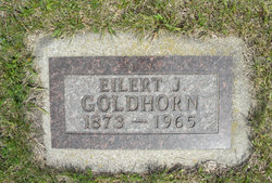
Eilert Johann Goldhorn
| Birth | : | 10 Nov 1872 Bunde, Landkreis Leer, Lower Saxony (Niedersachsen), Germany |
| Death | : | 8 Oct 1965 Watertown, Codington County, South Dakota, USA |
| Burial | : | Attwood Cemetery, Kidsgrove, Newcastle-Under-Lyme Borough, England |
| Coordinate | : | 53.0889200, -2.2350700 |
| Description | : | Eilert Goldhorn was born in Germany on Nov. 10, 1873. He passed away Oct. 8, 1965, at the age of 92 years at the Memorial Hospital in Watertown. Before comingt to Castlewood, where he lived for about 60 years, he lived in Parkersberg and George, Iowa; and Brookings, Sou. Dakota. At George, Iowa in 1902 he married Katie Powers, who died in 1915. In 1930 he married Mabel Hoftiezer, who died in 1964. He was a member of the Hamlin Reformed Church, where he served as an elder and Sunday School teacher for many years. He is survived by... Read More |
frequently asked questions (FAQ):
-
Where is Eilert Johann Goldhorn's memorial?
Eilert Johann Goldhorn's memorial is located at: Attwood Cemetery, Kidsgrove, Newcastle-Under-Lyme Borough, England.
-
When did Eilert Johann Goldhorn death?
Eilert Johann Goldhorn death on 8 Oct 1965 in Watertown, Codington County, South Dakota, USA
-
Where are the coordinates of the Eilert Johann Goldhorn's memorial?
Latitude: 53.0889200
Longitude: -2.2350700
Family Members:
Parent

Spouse
Siblings
Children
Flowers:


Nearby Cemetories:
1. St. James the Apostle Churchyard
Newchapel, Newcastle-Under-Lyme Borough, England
Coordinate: 53.0874630, -2.2069790
2. St. John the Evangelist Churchyard
Goldenhill, Stoke-on-Trent Unitary Authority, England
Coordinate: 53.0749010, -2.2189830
3. St Martin Churchyard
Talke, Newcastle-Under-Lyme Borough, England
Coordinate: 53.0755440, -2.2618170
4. All Saints Churchyard
Church Lawton, Cheshire East Unitary Authority, England
Coordinate: 53.0987050, -2.2679300
5. St Thomas Churchyard
Mow Cop, Newcastle-Under-Lyme Borough, England
Coordinate: 53.1127280, -2.2101350
6. Tunstall Cemetery
Tunstall, Stoke-on-Trent Unitary Authority, England
Coordinate: 53.0618690, -2.2180260
7. Christ Church Churchyard
Tunstall, Stoke-on-Trent Unitary Authority, England
Coordinate: 53.0625400, -2.2112840
8. All Saints Churchyard
Odd Rode, Cheshire East Unitary Authority, England
Coordinate: 53.1142100, -2.2644690
9. St Mary Magdalene Churchyard
Alsager, Cheshire East Unitary Authority, England
Coordinate: 53.0960640, -2.3071370
10. Audley Methodist Church Cemetery
Bignall End, Newcastle-Under-Lyme Borough, England
Coordinate: 53.0574320, -2.2944720
11. Holy Trinity Churchyard
Chesterton, Stratford-on-Avon District, England
Coordinate: 53.0418320, -2.2523770
12. Christ Church Churchyard
Alsager, Cheshire East Unitary Authority, England
Coordinate: 53.0977630, -2.3166660
13. St John the Baptist Churchyard
Burslem, Stoke-on-Trent Unitary Authority, England
Coordinate: 53.0425850, -2.1962510
14. St James the Great Churchyard
Audley, Newcastle-Under-Lyme Borough, England
Coordinate: 53.0548480, -2.3014800
15. Parish church of st saviour smallthorne
Smallthorne, Stoke-on-Trent Unitary Authority, England
Coordinate: 53.0497445, -2.1758707
16. St Bartholomew Churchyard
Norton in the Moors, Stoke-on-Trent Unitary Authority, England
Coordinate: 53.0604630, -2.1595270
17. Smallthorne Cemetery
Smallthorne, Stoke-on-Trent Unitary Authority, England
Coordinate: 53.0480310, -2.1765950
18. Chesterton Cemetery
Newcastle-under-Lyme, Newcastle-Under-Lyme Borough, England
Coordinate: 53.0352240, -2.2500500
19. St Anne Churchyard
Brown Edge, Staffordshire Moorlands District, England
Coordinate: 53.0832490, -2.1429880
20. Burslem Cemetery
Burslem, Stoke-on-Trent Unitary Authority, England
Coordinate: 53.0463020, -2.1747030
21. Audley Cemetery
Audley, Newcastle-Under-Lyme Borough, England
Coordinate: 53.0550140, -2.3103040
22. St. Lawrence Churchyard
Biddulph, Staffordshire Moorlands District, England
Coordinate: 53.1281320, -2.1659070
23. St John the Baptist Churchyard
Smallwood, Cheshire East Unitary Authority, England
Coordinate: 53.1381700, -2.2913100
24. St Margaret Churchyard
Wolstanton, Newcastle-Under-Lyme Borough, England
Coordinate: 53.0296810, -2.2154990