
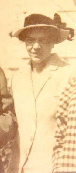
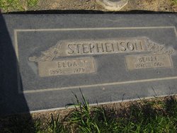
Elda Alveda Thew Stephenson
| Birth | : | 7 Jul 1893 Denison, Crawford County, Iowa, USA |
| Death | : | 7 May 1979 Corvallis, Benton County, Oregon, USA |
| Burial | : | Lewis County Memorial Gardens, Weston, Lewis County, USA |
| Coordinate | : | 39.0224390, -80.4202340 |
| Description | : | Parents: Herbert Thew & Laney Doty Source: 1900-1910C |
frequently asked questions (FAQ):
-
Where is Elda Alveda Thew Stephenson's memorial?
Elda Alveda Thew Stephenson's memorial is located at: Lewis County Memorial Gardens, Weston, Lewis County, USA.
-
When did Elda Alveda Thew Stephenson death?
Elda Alveda Thew Stephenson death on 7 May 1979 in Corvallis, Benton County, Oregon, USA
-
Where are the coordinates of the Elda Alveda Thew Stephenson's memorial?
Latitude: 39.0224390
Longitude: -80.4202340
Family Members:
Parent

Spouse

Siblings
Children
Flowers:


Nearby Cemetories:
1. Peterson Cemetery
Weston, Lewis County, USA
Coordinate: 39.0224991, -80.4244003
2. Bush Cemetery
Horner, Lewis County, USA
Coordinate: 39.0147018, -80.4021988
3. Smiths Run Cemetery
Weston, Lewis County, USA
Coordinate: 39.0463070, -80.4173810
4. Smith Family Cemetery
Lewis County, USA
Coordinate: 39.0457993, -80.4297028
5. Horner Methodist Church Cemetery
Weston, Lewis County, USA
Coordinate: 39.0041069, -80.3845373
6. Old Arnold Cemetery
Weston, Lewis County, USA
Coordinate: 39.0350120, -80.4693550
7. Glady Cemetery
Horner, Lewis County, USA
Coordinate: 38.9846992, -80.4389038
8. Machpelah Cemetery
Weston, Lewis County, USA
Coordinate: 39.0475400, -80.4640760
9. Brownsville Cemetery
Lewis County, USA
Coordinate: 39.0163994, -80.4756012
10. Forest Lawn Memorial Gardens
Jane Lew, Lewis County, USA
Coordinate: 39.0649986, -80.4328003
11. Louisa Jane Methodist Chapel Cemetery
Alkires Mills, Lewis County, USA
Coordinate: 38.9786900, -80.4260310
12. Weston State Hospital Cemetery
Weston, Lewis County, USA
Coordinate: 39.0395050, -80.4727760
13. Laurel Lick Cemetery
Lewis County, USA
Coordinate: 39.0386009, -80.3617020
14. Hicks Cemetery
Lewis County, USA
Coordinate: 39.0717010, -80.4077988
15. Corathers Cemetery
Lewis County, USA
Coordinate: 38.9693927, -80.4128386
16. Miller Cemetery
Horner, Lewis County, USA
Coordinate: 39.0022800, -80.3496370
17. Morrison Cemetery
Berlin, Lewis County, USA
Coordinate: 39.0633100, -80.3648120
18. Butcher Cemetery
Turnertown, Lewis County, USA
Coordinate: 39.0727997, -80.4614029
19. Friendship Cemetery
Berlin, Lewis County, USA
Coordinate: 39.0760994, -80.3794022
20. Georgetown Cemetery
Lewis County, USA
Coordinate: 38.9638000, -80.3835200
21. Buckhannon Run Cemetery
Berlin, Lewis County, USA
Coordinate: 39.0365720, -80.3361230
22. Thomas Law Cemetery
Jane Lew, Lewis County, USA
Coordinate: 39.0893270, -80.4326240
23. Middle Run Cemetery
Weston, Lewis County, USA
Coordinate: 39.0149994, -80.5081024
24. Ward Cemetery
Lewis County, USA
Coordinate: 38.9975860, -80.5051990