
| Birth | : | 27 Jul 1899 Denison, Crawford County, Iowa, USA |
| Death | : | 1962 Washington, USA |
| Burial | : | Imogene Baptist Church Cemetery, Pine Ridge, Surry County, USA |
| Coordinate | : | 36.5521393, -80.7203598 |
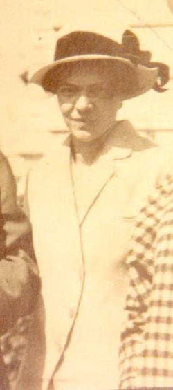
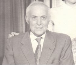
| Description | : | from a FAG member: Son of Herbert Ellsworth Thew and Laney Viola Doty. |
frequently asked questions (FAQ):
-
Where is Ivan Horace Thew's memorial?
Ivan Horace Thew's memorial is located at: Imogene Baptist Church Cemetery, Pine Ridge, Surry County, USA.
-
When did Ivan Horace Thew death?
Ivan Horace Thew death on 1962 in Washington, USA
-
Where are the coordinates of the Ivan Horace Thew's memorial?
Latitude: 36.5521393
Longitude: -80.7203598
Family Members:
Parent

Spouse
Siblings
Flowers:


Nearby Cemetories:
1. Imogene Baptist Church Cemetery
Pine Ridge, Surry County, USA
Coordinate: 36.5521393, -80.7203598
2. Snow Cemetery
Mount Airy, Surry County, USA
Coordinate: 36.5422500, -80.7299170
3. James Harding Golding Family Cemetery
Mount Airy, Surry County, USA
Coordinate: 36.5539500, -80.7023900
4. New Bethel Baptist Church Cemetery
Mount Airy, Surry County, USA
Coordinate: 36.5535920, -80.7020960
5. New Bethel Baptist South
Mount Airy, Surry County, USA
Coordinate: 36.5533870, -80.7018270
6. Furbee Cemetery
Wetzel County, USA
Coordinate: 36.5363984, -80.7316687
7. Beamer Cemetery
Mount Airy, Surry County, USA
Coordinate: 36.5343060, -80.7012220
8. Johnson Puckett Cemetery
Mount Airy, Surry County, USA
Coordinate: 36.5306740, -80.7362830
9. Maple Grove United Methodist Church Cemetery
Pine Ridge, Surry County, USA
Coordinate: 36.5237770, -80.7171402
10. McCraw Family Cemetery
Lambsburg, Carroll County, USA
Coordinate: 36.5814200, -80.7235270
11. Surratt Cemetery
Lambsburg, Carroll County, USA
Coordinate: 36.5790920, -80.7396730
12. Vernon-Leonard Cemetery
Cana, Carroll County, USA
Coordinate: 36.5841200, -80.7217600
13. Golding Family Cemetery
Mount Airy, Surry County, USA
Coordinate: 36.5326670, -80.7528330
14. Christopher W Jones Cemetery
Cana, Carroll County, USA
Coordinate: 36.5819178, -80.7000292
15. Zion Hill Primitive Baptist Church Cemetery
Crooked Oak, Surry County, USA
Coordinate: 36.5313339, -80.7572250
16. Oak Ridge Baptist Church Cemetery
Cana, Carroll County, USA
Coordinate: 36.5718760, -80.6800790
17. Flower Gap Primitive Baptist Church Cemetery
Cana, Carroll County, USA
Coordinate: 36.5900510, -80.7286500
18. Phillip Haywood McBride Family Cemetery
Lowgap, Surry County, USA
Coordinate: 36.5602950, -80.7678630
19. Cedar Lane-Easter Cemetery
Cana, Carroll County, USA
Coordinate: 36.5898610, -80.7356070
20. Easter Family Cemetery
Carroll County, USA
Coordinate: 36.5900270, -80.7354860
21. Blue Ridge Baptist Church Cemetery
Crooked Oak, Surry County, USA
Coordinate: 36.5490440, -80.7727400
22. Zion United Methodist Cemetery
Mount Airy, Surry County, USA
Coordinate: 36.5326958, -80.6725845
23. George Jeremiah Edwards Family Cemetery
Cana, Carroll County, USA
Coordinate: 36.5937600, -80.7370100
24. Gray Cemetery
Cana, Carroll County, USA
Coordinate: 36.5943420, -80.7034040