
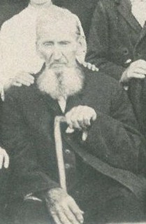
Elder Reuben Perry “Uncle” Scott
| Birth | : | Dec 1826 Kentucky, USA |
| Death | : | 17 Apr 1910 Clay County, Tennessee, USA |
| Burial | : | Rock Springs Cemetery, Celina, Clay County, USA |
| Coordinate | : | 36.6096992, -85.4167023 |
| Description | : | Scott, Reuben Uncle Reuben Scott, as he was familiarly known for many miles around Old Rock Spring, in Northern Tennessee, was called to his reward on April 17, 1910. His life was a very interesting and encouraging one to all Christians who knew him. He gave himself early (at the age of fifteen) to the Master and ever afterwards valiantly carried the banner of his Leader. He began to labor publicly at about twenty years of age and continued to preach at home and in all the surrounding country around old Rock Spring till called home. He was eighty-four years... Read More |
frequently asked questions (FAQ):
-
Where is Elder Reuben Perry “Uncle” Scott's memorial?
Elder Reuben Perry “Uncle” Scott's memorial is located at: Rock Springs Cemetery, Celina, Clay County, USA.
-
When did Elder Reuben Perry “Uncle” Scott death?
Elder Reuben Perry “Uncle” Scott death on 17 Apr 1910 in Clay County, Tennessee, USA
-
Where are the coordinates of the Elder Reuben Perry “Uncle” Scott's memorial?
Latitude: 36.6096992
Longitude: -85.4167023
Family Members:
Children
Flowers:


Nearby Cemetories:
1. Rock Springs Cemetery
Celina, Clay County, USA
Coordinate: 36.6096992, -85.4167023
2. Thompson Webb Cemetery
Celina, Clay County, USA
Coordinate: 36.6090110, -85.4202270
3. Crossroads Cemetery
Clay County, USA
Coordinate: 36.6074982, -85.4210968
4. Williams Cemetery
Pea Ridge, Clay County, USA
Coordinate: 36.6150017, -85.4169006
5. Ashlock Cemetery
Ashlock, Cumberland County, USA
Coordinate: 36.6208380, -85.4283620
6. Hattie's Houses Cemetery
Pea Ridge, Clay County, USA
Coordinate: 36.6159200, -85.4360040
7. Mullins - Kerr Cemetery
Pea Ridge, Clay County, USA
Coordinate: 36.5951330, -85.4317470
8. Killman Cemetery
Ashlock, Cumberland County, USA
Coordinate: 36.6325850, -85.4256430
9. Donaldson Cemetery
Pea Ridge, Clay County, USA
Coordinate: 36.5952988, -85.4424973
10. Lester and Winnie Spears Cemetery
Burkesville, Cumberland County, USA
Coordinate: 36.6304420, -85.3829600
11. Bowe Cemetery
Pea Ridge, Clay County, USA
Coordinate: 36.5833015, -85.4439011
12. Smith Cemetery
Monroe County, USA
Coordinate: 36.6439881, -85.4203414
13. Key Cemetery
Pea Ridge, Clay County, USA
Coordinate: 36.5875015, -85.4518967
14. Grover Rich Cemetery
Pea Ridge, Clay County, USA
Coordinate: 36.5946370, -85.4602970
15. Dulworth Cemetery
Cumberland County, USA
Coordinate: 36.6292100, -85.3757900
16. Short's Chapel Cemetery
Monroe County, USA
Coordinate: 36.6281013, -85.4589005
17. Thompson Cemetery
Clay County, USA
Coordinate: 36.6123700, -85.4666600
18. Ray Williams Cemetery
Pea Ridge, Clay County, USA
Coordinate: 36.5856130, -85.4598120
19. Riley Cemetery
Littrell, Cumberland County, USA
Coordinate: 36.6509768, -85.3853975
20. Peyton Spear Cemetery
Peytonsburg, Cumberland County, USA
Coordinate: 36.6481590, -85.3778400
21. Capps-Key Cemetery
Burkesville, Cumberland County, USA
Coordinate: 36.6605280, -85.4129330
22. Pruitt Cemetery
Peytonsburg, Cumberland County, USA
Coordinate: 36.6571270, -85.3874590
23. Spears Chapel Cemetery
Peytonsburg, Cumberland County, USA
Coordinate: 36.6495790, -85.3714410
24. Poplar Grove Cemetery
Kettle, Cumberland County, USA
Coordinate: 36.6680090, -85.4074180