
Eleazar Read
| Birth | : | 2 Feb 1740 Dunstable, Middlesex County, Massachusetts, USA |
| Death | : | 10 Aug 1811 Dunstable, Middlesex County, Massachusetts, USA |
| Burial | : | Sydenham Cemetery, Sydenham, Christchurch City, New Zealand |
| Coordinate | : | -43.5582330, 172.6254900 |
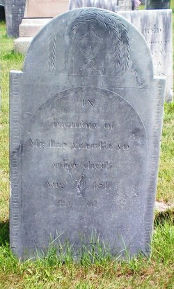
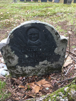
| Inscription | : | In Memory of MR. ELEAZAR READ who died August 10, 1811 aged 61 Source: Nason, Elias "History of Dunstable, Massachusetts": A Mudge & Son, printers, Boston 1877 |
| Description | : | Eleazer Read. son of Timothy and Mary (Cummings) Read, was born in Dunstable, Massachusetts in February 1740. He was a soldier in the Revolutionary War and fought in the Battle of Bunker Hill. He married Rachel Cummings, Children of Eleazer and Rachel (Cummings) Read all born in Dunstable, Massachusetts were: Rachel, born 4 June 1770 Rhoda, born 26 November 1771 Caleb, born 7 August 1775 [Calob in Vital Records] Leonard, born 4 April 1777 Rebecca, born 5 March 1779 [Rebeckah in Vital Records] Betsey, born 17 December 1800 [Betty, daughter of Eleazer and Rachel, born 17 December [after 1799] in Vital Records] Sources: "Historic Homes &... Read More |
frequently asked questions (FAQ):
-
Where is Eleazar Read's memorial?
Eleazar Read's memorial is located at: Sydenham Cemetery, Sydenham, Christchurch City, New Zealand.
-
When did Eleazar Read death?
Eleazar Read death on 10 Aug 1811 in Dunstable, Middlesex County, Massachusetts, USA
-
Where are the coordinates of the Eleazar Read's memorial?
Latitude: -43.5582330
Longitude: 172.6254900
Family Members:
Parent
Spouse
Children
Flowers:


Nearby Cemetories:
1. Sydenham Cemetery
Sydenham, Christchurch City, New Zealand
Coordinate: -43.5582330, 172.6254900
2. Addington Cemetery
Addington, Christchurch City, New Zealand
Coordinate: -43.5434880, 172.6235790
3. Blessed Sacrament Cathedral
Christchurch, Christchurch City, New Zealand
Coordinate: -43.5384250, 172.6458880
4. Barbadoes Street Cemetery
Christchurch, Christchurch City, New Zealand
Coordinate: -43.5230370, 172.6458760
5. Avonside Anglican Cemetery
Avonside, Christchurch City, New Zealand
Coordinate: -43.5265780, 172.6585100
6. Woolston Cemetery
Woolston, Christchurch City, New Zealand
Coordinate: -43.5559770, 172.6825880
7. Mount Magdala Cemetery
Halswell, Christchurch City, New Zealand
Coordinate: -43.5622700, 172.5672600
8. St. Mary's Anglican Church Cemetery
Halswell, Christchurch City, New Zealand
Coordinate: -43.5794830, 172.5686440
9. St Peter's Anglican Churchyard
Upper Riccarton, Christchurch City, New Zealand
Coordinate: -43.5317570, 172.5701330
10. Bromley Cemetery
Bromley, Christchurch City, New Zealand
Coordinate: -43.5384980, 172.6862960
11. Canterbury Memorial Gardens and Crematorium
Bromley, Christchurch City, New Zealand
Coordinate: -43.5420790, 172.6893340
12. Linwood Cemetery
Linwood, Christchurch City, New Zealand
Coordinate: -43.5299220, 172.6828180
13. Canterbury Provincial Memorial
Bromley, Christchurch City, New Zealand
Coordinate: -43.5329620, 172.6896830
14. Memorial Park Cemetery
Bromley, Christchurch City, New Zealand
Coordinate: -43.5291840, 172.6877410
15. Ruru Lawn Cemetery
Bromley, Christchurch City, New Zealand
Coordinate: -43.5322470, 172.6918010
16. St Paul's Anglican Church Cemetery
Papanui, Christchurch City, New Zealand
Coordinate: -43.4966540, 172.6067210
17. Waimairi Cemetery
Burnside, Christchurch City, New Zealand
Coordinate: -43.4997760, 172.5773860
18. Avonhead Memorial Cemetery
Avonhead, Christchurch City, New Zealand
Coordinate: -43.5095390, 172.5503920
19. All Saints Church Cemetery
Burwood, Christchurch City, New Zealand
Coordinate: -43.4999650, 172.6865820
20. St Cuthbert's Cemetery
Governors Bay, Christchurch City, New Zealand
Coordinate: -43.6326900, 172.6458000
21. Lyttelton Anglican Cemetery
Lyttelton, Christchurch City, New Zealand
Coordinate: -43.5985240, 172.7226520
22. All Saint's Churchyard
Prebbleton, Selwyn District, New Zealand
Coordinate: -43.5781040, 172.5131430
23. Lyttelton Cemetery
Lyttelton, Christchurch City, New Zealand
Coordinate: -43.6018530, 172.7255220
24. Prebbleton Cemetery
Prebbleton, Selwyn District, New Zealand
Coordinate: -43.5887200, 172.5053500