
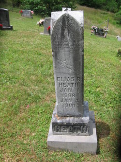
Elias B Heath
| Birth | : | 1 Jan 1866 Missouri, USA |
| Death | : | 4 Jan 1900 Lewis County, West Virginia, USA |
| Burial | : | Pumphrey Cemetery, Orlando, Lewis County, USA |
| Coordinate | : | 38.9275880, -80.6216500 |
| Description | : | WESTON INDEPENDENT January 16, 1900 ELIAS HEATH, Died at his home near Aspinall, January 4, of consumption. |
frequently asked questions (FAQ):
-
Where is Elias B Heath's memorial?
Elias B Heath's memorial is located at: Pumphrey Cemetery, Orlando, Lewis County, USA.
-
When did Elias B Heath death?
Elias B Heath death on 4 Jan 1900 in Lewis County, West Virginia, USA
-
Where are the coordinates of the Elias B Heath's memorial?
Latitude: 38.9275880
Longitude: -80.6216500
Family Members:
Parent
Spouse
Siblings

Children
Flowers:


Nearby Cemetories:
1. Pumphrey Cemetery
Orlando, Lewis County, USA
Coordinate: 38.9275880, -80.6216500
2. Mick Cemetery
Gilmer County, USA
Coordinate: 38.9157200, -80.6316400
3. Finster Chapel Cemetery
Peterson, Lewis County, USA
Coordinate: 38.9300003, -80.5999985
4. Queen Family Cemetery
Copley, Lewis County, USA
Coordinate: 38.9499000, -80.6130000
5. Heater Cemetery
Burnsville, Braxton County, USA
Coordinate: 38.9024560, -80.6100370
6. Tumbling Cemetery
Gilmer County, USA
Coordinate: 38.9085999, -80.6594009
7. Tomblin Cemetery
Blackburn, Gilmer County, USA
Coordinate: 38.9076650, -80.6597330
8. Montgomery Cemetery
Bealls Mills, Lewis County, USA
Coordinate: 38.9648890, -80.6035400
9. Blackburn Cemetery
Blackburn, Gilmer County, USA
Coordinate: 38.9235700, -80.6743200
10. Boilon Cemetery
Gilmer County, USA
Coordinate: 38.9519005, -80.6718979
11. Saint Bridget's Church Cemetery
Weston, Lewis County, USA
Coordinate: 38.9319400, -80.5572970
12. Schoonover-Dawson Cemetery
Donlan, Gilmer County, USA
Coordinate: 38.9461770, -80.6854790
13. Barrett Cemetery
Burnsville, Braxton County, USA
Coordinate: 38.8778000, -80.6528015
14. Canfield Cemetery
Gilmer, Gilmer County, USA
Coordinate: 38.9071999, -80.6900024
15. Rogers Cemetery
Gilmer County, USA
Coordinate: 38.9406013, -80.6936035
16. Locust Knob Cemetery
Stouts Mills, Gilmer County, USA
Coordinate: 38.8990000, -80.6880000
17. Snyder Cemetery
Gilmer County, USA
Coordinate: 38.9006004, -80.6964035
18. Keith Cemetery
Gilmer County, USA
Coordinate: 38.9561005, -80.6986008
19. Old Field Fork Cemetery
Lewis County, USA
Coordinate: 38.9827995, -80.6710968
20. Saint Bernard Church Cemetery
Weston, Lewis County, USA
Coordinate: 38.9928000, -80.5926940
21. Dyer Cemetery
Gilmer County, USA
Coordinate: 38.9319000, -80.7110977
22. McHenry Cemetery
Gilmer County, USA
Coordinate: 38.9341870, -80.7130200
23. Peterson Village Cemetery
Peterson, Lewis County, USA
Coordinate: 38.8938270, -80.5400510
24. Hoover Cemetery
Burnsville, Braxton County, USA
Coordinate: 38.8619600, -80.6644170