
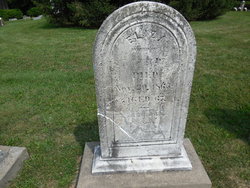
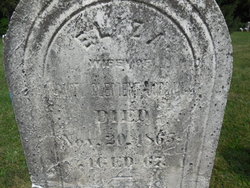
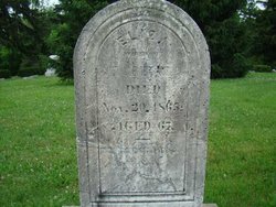
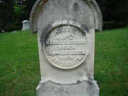
Eliza Dyer Jordan
| Birth | : | 1 Sep 1798 |
| Death | : | 20 Nov 1865 Jefferson County, Iowa, USA |
| Burial | : | Walnut Grove Cemetery, Elm Store, Randolph County, USA |
| Coordinate | : | 36.4914017, -91.1967010 |
| Plot | : | Old.P.066 |
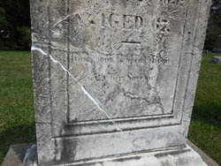
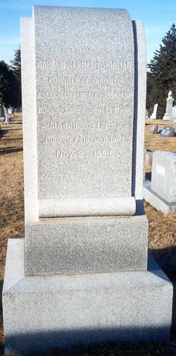
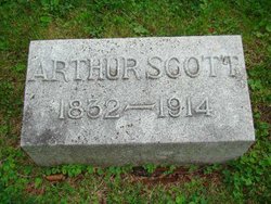
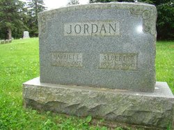
| Description | : | Memorial updated August 13, 2013: Married Clement Jordan on May 20, 1820. Children: Emily D Jordan Wells Frances E Jordan Eaton Clement Jordan, Jr. Caroline E Jordan Wells William Henry Jordan Arthur Scott Jordan Charles Franklin Jordan Albert Rufus Jordan Harry Jordan ------- "1879 History of Jefferson County", Page 488 "November 20, 1865, the death of Mrs. Eliza F. (DYER) JORDAN occurred. Owing to the rapid increase of population in the surrounding country, the little (Old Fairfield City) Cemetery was well filled up, and available lots were difficult to obtain. Capt. Clement JORDAN, husband of Eliza, was unable to obtain such a lot as he desired, and her remains were deposited in the... Read More |
frequently asked questions (FAQ):
-
Where is Eliza Dyer Jordan's memorial?
Eliza Dyer Jordan's memorial is located at: Walnut Grove Cemetery, Elm Store, Randolph County, USA.
-
When did Eliza Dyer Jordan death?
Eliza Dyer Jordan death on 20 Nov 1865 in Jefferson County, Iowa, USA
-
Where are the coordinates of the Eliza Dyer Jordan's memorial?
Latitude: 36.4914017
Longitude: -91.1967010
Family Members:
Spouse
Children
Flowers:


Nearby Cemetories:
1. Mount Carmel Cemetery
Calm, Oregon County, USA
Coordinate: 36.5106010, -91.1643982
2. Old Elmore Thomas field
Billmore, Oregon County, USA
Coordinate: 36.5237770, -91.1980250
3. Stubblefield Cemetery
Dalton, Randolph County, USA
Coordinate: 36.4597015, -91.1718979
4. Spring Valley Cemetery
Billmore, Oregon County, USA
Coordinate: 36.5324670, -91.2003420
5. Reynolds Cemetery
Elm Store, Randolph County, USA
Coordinate: 36.4491997, -91.1860962
6. Mosely Cemetery
Randolph County, USA
Coordinate: 36.4460983, -91.1975021
7. Church of God Cemetery
Oregon County, USA
Coordinate: 36.5023500, -91.2580200
8. Bryan Cemetery
Randolph County, USA
Coordinate: 36.4458008, -91.1552963
9. King Cemetery
Randolph County, USA
Coordinate: 36.4357986, -91.1836014
10. Myrtle Cemetery
Myrtle, Oregon County, USA
Coordinate: 36.5133900, -91.2664300
11. Dalton Cemetery
Randolph County, USA
Coordinate: 36.4338989, -91.1496964
12. Coe Cemetery
Warm Springs, Randolph County, USA
Coordinate: 36.4732400, -91.1102200
13. Eaton Cemetery
Randolph County, USA
Coordinate: 36.4185982, -91.1999969
14. New Home Cemetery
Tucker (Gatewood), Ripley County, USA
Coordinate: 36.5112100, -91.1089800
15. Liberty Cemetery
Calm, Oregon County, USA
Coordinate: 36.5586500, -91.1549600
16. Pigman Mound Archeological Site
Calm, Oregon County, USA
Coordinate: 36.5717100, -91.1784800
17. Bailey Cemetery
Dalton, Randolph County, USA
Coordinate: 36.4049225, -91.1895065
18. O'Neal
Billmore, Oregon County, USA
Coordinate: 36.5712170, -91.2415410
19. Upshaw Cemetery
Randolph County, USA
Coordinate: 36.4185982, -91.1207962
20. Hamilton
Warm Springs, Randolph County, USA
Coordinate: 36.4469170, -91.0900830
21. White Cemetery
Randolph County, USA
Coordinate: 36.3939018, -91.1821976
22. Byrd Cemetery
Myrtle, Oregon County, USA
Coordinate: 36.5186005, -91.3143997
23. Bellah Cemetery
Ravenden Springs, Randolph County, USA
Coordinate: 36.4207993, -91.2825012
24. Crass Homestead
Myrtle, Oregon County, USA
Coordinate: 36.5359695, -91.3084671