
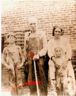
Eliza Frances “Lizie” Key Blakely Ashlock Smith
| Birth | : | 8 Jun 1882 Cumberland County, Kentucky, USA |
| Death | : | 24 Nov 1968 Clay County, Tennessee, USA |
| Burial | : | Rock Springs Cemetery, Celina, Clay County, USA |
| Coordinate | : | 36.6096992, -85.4167023 |
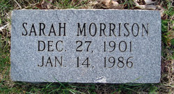
| Description | : | Married first to James William "Bill" Blakely before 1900, he died in 1942 married 2nd to Willie Clinton Ashlock on 27 Nov. 1944 in Noblesville, In, he died in 1956 married 3rd to Willie Lafayette Smith on 04 Jan 1962 in Overton Co., TN She was the mother of: John Thomas "Johnny" Blakely (1900-1930) Sarah R. "Sissie" Killmon Morrison (1901-1986) James William "Jimmy" Blakely (1904-1981) Fannie Spears (1905-1928) Susan Jane "Susie" Smith (1906-1981) Nancy Melvina "Vinie" Melton (1910-1988) Oria Lee Reecer (1911-1985) Walter Frank Blakely (1920-1987) |
frequently asked questions (FAQ):
-
Where is Eliza Frances “Lizie” Key Blakely Ashlock Smith's memorial?
Eliza Frances “Lizie” Key Blakely Ashlock Smith's memorial is located at: Rock Springs Cemetery, Celina, Clay County, USA.
-
When did Eliza Frances “Lizie” Key Blakely Ashlock Smith death?
Eliza Frances “Lizie” Key Blakely Ashlock Smith death on 24 Nov 1968 in Clay County, Tennessee, USA
-
Where are the coordinates of the Eliza Frances “Lizie” Key Blakely Ashlock Smith's memorial?
Latitude: 36.6096992
Longitude: -85.4167023
Family Members:
Parent

Spouse
Siblings
Children
Flowers:


Nearby Cemetories:
1. Rock Springs Cemetery
Celina, Clay County, USA
Coordinate: 36.6096992, -85.4167023
2. Thompson Webb Cemetery
Celina, Clay County, USA
Coordinate: 36.6090110, -85.4202270
3. Crossroads Cemetery
Clay County, USA
Coordinate: 36.6074982, -85.4210968
4. Williams Cemetery
Pea Ridge, Clay County, USA
Coordinate: 36.6150017, -85.4169006
5. Ashlock Cemetery
Ashlock, Cumberland County, USA
Coordinate: 36.6208380, -85.4283620
6. Hattie's Houses Cemetery
Pea Ridge, Clay County, USA
Coordinate: 36.6159200, -85.4360040
7. Mullins - Kerr Cemetery
Pea Ridge, Clay County, USA
Coordinate: 36.5951330, -85.4317470
8. Killman Cemetery
Ashlock, Cumberland County, USA
Coordinate: 36.6325850, -85.4256430
9. Donaldson Cemetery
Pea Ridge, Clay County, USA
Coordinate: 36.5952988, -85.4424973
10. Lester and Winnie Spears Cemetery
Burkesville, Cumberland County, USA
Coordinate: 36.6304420, -85.3829600
11. Bowe Cemetery
Pea Ridge, Clay County, USA
Coordinate: 36.5833015, -85.4439011
12. Smith Cemetery
Monroe County, USA
Coordinate: 36.6439881, -85.4203414
13. Key Cemetery
Pea Ridge, Clay County, USA
Coordinate: 36.5875015, -85.4518967
14. Grover Rich Cemetery
Pea Ridge, Clay County, USA
Coordinate: 36.5946370, -85.4602970
15. Dulworth Cemetery
Cumberland County, USA
Coordinate: 36.6292100, -85.3757900
16. Short's Chapel Cemetery
Monroe County, USA
Coordinate: 36.6281013, -85.4589005
17. Thompson Cemetery
Clay County, USA
Coordinate: 36.6123700, -85.4666600
18. Ray Williams Cemetery
Pea Ridge, Clay County, USA
Coordinate: 36.5856130, -85.4598120
19. Riley Cemetery
Littrell, Cumberland County, USA
Coordinate: 36.6509768, -85.3853975
20. Peyton Spear Cemetery
Peytonsburg, Cumberland County, USA
Coordinate: 36.6481590, -85.3778400
21. Capps-Key Cemetery
Burkesville, Cumberland County, USA
Coordinate: 36.6605280, -85.4129330
22. Pruitt Cemetery
Peytonsburg, Cumberland County, USA
Coordinate: 36.6571270, -85.3874590
23. Spears Chapel Cemetery
Peytonsburg, Cumberland County, USA
Coordinate: 36.6495790, -85.3714410
24. Poplar Grove Cemetery
Kettle, Cumberland County, USA
Coordinate: 36.6680090, -85.4074180