
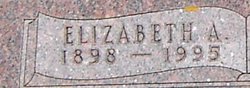
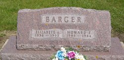
Elizabeth A. Schechtman Barger
| Birth | : | 6 Oct 1898 |
| Death | : | 27 Nov 1995 |
| Burial | : | Sand Lake Cemetery, Sand Lake, Kent County, USA |
| Coordinate | : | 43.2861480, -85.5313380 |
| Description | : | Married 06 Feb 1919 at Manchester. |
frequently asked questions (FAQ):
-
Where is Elizabeth A. Schechtman Barger's memorial?
Elizabeth A. Schechtman Barger's memorial is located at: Sand Lake Cemetery, Sand Lake, Kent County, USA.
-
When did Elizabeth A. Schechtman Barger death?
Elizabeth A. Schechtman Barger death on 27 Nov 1995 in
-
Where are the coordinates of the Elizabeth A. Schechtman Barger's memorial?
Latitude: 43.2861480
Longitude: -85.5313380
Family Members:
Parent
Spouse
Siblings

Flowers:


Nearby Cemetories:
1. Sand Lake Cemetery
Sand Lake, Kent County, USA
Coordinate: 43.2861480, -85.5313380
2. Saint Mary's Cemetery
Sand Lake, Kent County, USA
Coordinate: 43.2717018, -85.4969025
3. Punches Cemetery
Cedar Springs, Kent County, USA
Coordinate: 43.2467003, -85.5317001
4. Crandall Cemetery
Ensley Center, Newaygo County, USA
Coordinate: 43.2938995, -85.5939026
5. Pierson Township Cemetery
Pierson, Montcalm County, USA
Coordinate: 43.3381004, -85.5006027
6. East Nelson Cemetery
Cedar Springs, Kent County, USA
Coordinate: 43.2355995, -85.4561005
7. Elmwood Cemetery
Cedar Springs, Kent County, USA
Coordinate: 43.2118988, -85.5532990
8. Solon Township Cemetery
Cedar Springs, Kent County, USA
Coordinate: 43.2344589, -85.6100235
9. North Ensley Cemetery
Ensley Center, Newaygo County, USA
Coordinate: 43.3671989, -85.5935974
10. Saint Johns Catholic Cemetery
Ensley Center, Newaygo County, USA
Coordinate: 43.3664017, -85.5969009
11. DeGraw Family Cemetery
Cedar Springs, Kent County, USA
Coordinate: 43.2066585, -85.4283281
12. Saint Margarets Catholic Cemetery
Spencer Township, Kent County, USA
Coordinate: 43.2063890, -85.4169440
13. Coral Cemetery
Coral, Montcalm County, USA
Coordinate: 43.3671989, -85.4060974
14. Trufant Cemetery
Maple Valley Township, Montcalm County, USA
Coordinate: 43.3083000, -85.3653030
15. Maple Valley Cemetery
Maple Valley Township, Montcalm County, USA
Coordinate: 43.3358002, -85.3724976
16. Coady Cemetery
Maple Valley Township, Montcalm County, USA
Coordinate: 43.3540520, -85.3825890
17. Reynolds Township Cemetery
Howard City, Montcalm County, USA
Coordinate: 43.4101300, -85.4767100
18. Christian Plains Cemetery
Croton Township, Newaygo County, USA
Coordinate: 43.4100200, -85.6028200
19. Courtland Township Cemetery
Rockford, Kent County, USA
Coordinate: 43.1521988, -85.4897003
20. Horton Cemetery
Oakfield Township, Kent County, USA
Coordinate: 43.1767006, -85.4111023
21. Spencer Mills Cemetery
Spencer Township, Kent County, USA
Coordinate: 43.2209920, -85.3556680
22. Bouton Family Farm Burial Site
Reynolds Township, Montcalm County, USA
Coordinate: 43.4294960, -85.5555570
23. Oak Grove Cemetery
Croton Township, Newaygo County, USA
Coordinate: 43.4061012, -85.6430969
24. Algoma Township Cemetery
Rockford, Kent County, USA
Coordinate: 43.1563988, -85.6252975