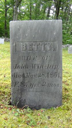
Elizabeth “Betsey” Dole Winship
| Birth | : | 1761 |
| Death | : | 28 Nov 1851 Maine, USA |
| Burial | : | Scribner Hill Cemetery Upper Yard, Otisfield, Oxford County, USA |
| Coordinate | : | 44.3903181, -70.7978794 |
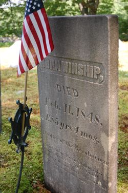
| Description | : | Daughter of Richard Dole and Martha Merrill of Newbury, MA. She married John Winship on Sept 14, 1786 They lived in Windham and later moved and settled in Otisfield, sometime after the 1790 Census. Betsey appears with her son Zachariah in the 1850 Census in Otisfield as Age 85 but may have been older based on year of birth from genealogies. They had the following children: Nancy b Jan 7, 1787 d Nov 30, 1879, unmarried. Martha M (probably Merrill) b Mar 20, 1791 d Apr 18, 1857 mar Harvey Scribner Dec 8, 1816. John b Apr 4, 1792 Sally b Nov 14, 1797... Read More |
frequently asked questions (FAQ):
-
Where is Elizabeth “Betsey” Dole Winship's memorial?
Elizabeth “Betsey” Dole Winship's memorial is located at: Scribner Hill Cemetery Upper Yard, Otisfield, Oxford County, USA.
-
When did Elizabeth “Betsey” Dole Winship death?
Elizabeth “Betsey” Dole Winship death on 28 Nov 1851 in Maine, USA
-
Where are the coordinates of the Elizabeth “Betsey” Dole Winship's memorial?
Latitude: 44.3903181
Longitude: -70.7978794
Family Members:
Parent
Spouse
Siblings
Flowers:
Nearby Cemetories:
1. Scribner Hill Cemetery Upper Yard
Otisfield, Oxford County, USA
Coordinate: 44.3903181, -70.7978794
2. Woodland Cemetery
Bethel, Oxford County, USA
Coordinate: 44.3902283, -70.7967911
3. Skillingston Cemetery
Bethel, Oxford County, USA
Coordinate: 44.4085999, -70.8197021
4. Riverside Cemetery
Bethel, Oxford County, USA
Coordinate: 44.4202995, -70.8058014
5. Flat Cemetery
West Bethel, Oxford County, USA
Coordinate: 44.3731003, -70.8497009
6. Songo Cemetery
Albany, Oxford County, USA
Coordinate: 44.3464012, -70.7908020
7. Pine Grove Cemetery
West Bethel, Oxford County, USA
Coordinate: 44.4055600, -70.8563100
8. Capen Family Cemetery
Bethel, Oxford County, USA
Coordinate: 44.4382283, -70.7925117
9. Mason Cemetery
Mason Township, Oxford County, USA
Coordinate: 44.3579270, -70.8525530
10. South Bethel Cemetery
Bethel, Oxford County, USA
Coordinate: 44.4160995, -70.7363968
11. Howe Hill Cemetery
Greenwood, Oxford County, USA
Coordinate: 44.3856010, -70.7142029
12. Chandler Hill Cemetery
Bethel, Oxford County, USA
Coordinate: 44.4392014, -70.7394028
13. Mount Abram Cemetery
Greenwood, Oxford County, USA
Coordinate: 44.4025002, -70.7078018
14. Mount Will Cemetery
North Bethel, Oxford County, USA
Coordinate: 44.4636002, -70.8028030
15. Middle Intervale Cemetery
Bethel, Oxford County, USA
Coordinate: 44.4638600, -70.7866200
16. Chapman Cemetery
Gilead, Oxford County, USA
Coordinate: 44.4114100, -70.9024900
17. Bird Hill Cemetery
Bethel, Oxford County, USA
Coordinate: 44.4234140, -70.6961680
18. East Bethel Cemetery
East Bethel, Oxford County, USA
Coordinate: 44.4648500, -70.7210200
19. Cole Cemetery
Greenwood, Oxford County, USA
Coordinate: 44.3638400, -70.6729000
20. Hicks Cemetery
Greenwood, Oxford County, USA
Coordinate: 44.3451390, -70.6823830
21. Hunts Corner Cemetery
Albany, Oxford County, USA
Coordinate: 44.2958333, -70.7606667
22. Black Family Cemetery
Newry, Oxford County, USA
Coordinate: 44.4889670, -70.7895730
23. Bartlett Cemetery
East Bethel, Oxford County, USA
Coordinate: 44.4817009, -70.7433014
24. Peabody Cemetery
Gilead, Oxford County, USA
Coordinate: 44.3987885, -70.9400635


