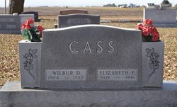
Elizabeth E. Easley Cass
| Birth | : | 31 Jan 1903 Alexandria, Thayer County, Nebraska, USA |
| Death | : | 12 Dec 1996 Aurora, Hamilton County, Nebraska, USA |
| Burial | : | Friendship United Methodist Church Cemetery, Rock Hill, York County, USA |
| Coordinate | : | 34.9066457, -80.9084393 |
| Description | : | Elizabeth E. Cass, the daughter of John Robert and Mable (Beebe) Easley, was born at Alexandria, Nebraska, on January 31, 1903, and died at Aurora, Nebraska, on December 12, 1996, at the age of 93 years, 10 months, and 11 days. As a small child the family moved to Sutton, Nebraska, where she attended Sutton Schools and graduated in 1921. She then attended and graduated from Nebraska Wesleyan University in Lincoln. She taught in the Sutton Schools and later taught in the schools at Ord, Nebraska. On August 14, 1932, she was united in marriage to Wilbur Cass,... Read More |
frequently asked questions (FAQ):
-
Where is Elizabeth E. Easley Cass's memorial?
Elizabeth E. Easley Cass's memorial is located at: Friendship United Methodist Church Cemetery, Rock Hill, York County, USA.
-
When did Elizabeth E. Easley Cass death?
Elizabeth E. Easley Cass death on 12 Dec 1996 in Aurora, Hamilton County, Nebraska, USA
-
Where are the coordinates of the Elizabeth E. Easley Cass's memorial?
Latitude: 34.9066457
Longitude: -80.9084393
Family Members:
Flowers:
Nearby Cemetories:
1. Friendship United Methodist Church Cemetery
Rock Hill, York County, USA
Coordinate: 34.9066457, -80.9084393
2. Providence Baptist Church Cemetery
Rock Hill, York County, USA
Coordinate: 34.9082480, -80.9071590
3. Church of Jesus Christ of Latter-day Sts Cemetery
Catawba, York County, USA
Coordinate: 34.9071007, -80.9012985
4. Foundation AME Zion Church Cemetery
Rock Hill, York County, USA
Coordinate: 34.9194412, -80.9269409
5. Catawba Indian Nation Cemetery
Rock Hill, York County, USA
Coordinate: 34.9043999, -80.8824005
6. Tabernacle AME Zion Church Cemetery
Rock Hill, York County, USA
Coordinate: 34.8749847, -80.9308090
7. Mount Hebron Baptist Church Cemetery
Rock Hill, York County, USA
Coordinate: 34.8943270, -80.9506690
8. Macedonia Baptist Church
Indian Land, Lancaster County, USA
Coordinate: 34.8975580, -80.8555820
9. Catawba Baptist Church Cemetery
Rock Hill, York County, USA
Coordinate: 34.9066887, -80.9643478
10. Gold Hill AME Zion Church Cemetery
Van Wyck, Lancaster County, USA
Coordinate: 34.9094340, -80.8472940
11. Hopewell Presbyterian Church Cemetery
Lesslie, York County, USA
Coordinate: 34.8835320, -80.9648800
12. Catawba Chapel A.M.E. Zion Church Cemetery
Catawba, York County, USA
Coordinate: 34.8555500, -80.9262500
13. Catawba Methodist Church Cemetery
Catawba, York County, USA
Coordinate: 34.8506851, -80.9131012
14. Neely's Creek ARP Church Cemetery
Rock Hill, York County, USA
Coordinate: 34.8673260, -80.9651080
15. Indian Land Baptist Church Cemetery
Indian Land, Lancaster County, USA
Coordinate: 34.9318840, -80.8367260
16. Six Mile Cemetery
Indian Land, Lancaster County, USA
Coordinate: 34.9308014, -80.8319016
17. Belair Methodist Church Cemetery
Lancaster County, USA
Coordinate: 34.9509964, -80.8433228
18. Rock Grove AME Zion Church Cemetery
Rock Hill, York County, USA
Coordinate: 34.9106910, -80.9970110
19. Van Wyck Presbyterian Church
Van Wyck, Lancaster County, USA
Coordinate: 34.8537520, -80.8471870
20. Van Wyck United Methodist Church Cemetery
Van Wyck, Lancaster County, USA
Coordinate: 34.8563970, -80.8403790
21. White Oak AME Zion Church Cemetery
Van Wyck, Lancaster County, USA
Coordinate: 34.8487570, -80.8484340
22. Higher Ground Church Cemetery
Indian Land, Lancaster County, USA
Coordinate: 34.9713300, -80.8597020
23. Center Grove Memorial Park
Indian Land, Lancaster County, USA
Coordinate: 34.9205500, -80.8122100
24. Edwards Cemetery
Indian Land, Lancaster County, USA
Coordinate: 34.9770010, -80.8607570


