
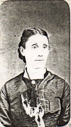


Elizabeth Jane Coffey Raper
| Birth | : | 12 Sep 1836 Owen County, Indiana, USA |
| Death | : | 10 Feb 1890 Pawnee City, Pawnee County, Nebraska, USA |
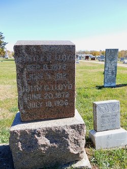
| Burial | : | Pawnee City Cemetery, Pawnee City, Pawnee County, USA |
| Coordinate | : | 40.1109009, -96.1608810 |
| Plot | : | Orig. 98- 3 |
| Description | : | OBITUARY Mrs. Elizabeth J. Raper, whose maiden name was Coffey, was born in Owen county, Indiana, September 12, 1836, and died in Pawnee City, February 10, 1890, aged fifty-three years, four months and 28 days. She was the second child in a family of six, all of whom are now sleeping, parents included, except the youngest son, Andrew N. Coffey of Tecumseh, Nebraska. Mrs. Raper was married to W. B. Raper in St. Joseph, Mo., January 17, 1867 since which time Pawnee and vicinity was her home. She became the mother of five children, one son and four daughters, two of whom... Read More |
frequently asked questions (FAQ):
-
Where is Elizabeth Jane Coffey Raper's memorial?
Elizabeth Jane Coffey Raper's memorial is located at: Pawnee City Cemetery, Pawnee City, Pawnee County, USA.
-
When did Elizabeth Jane Coffey Raper death?
Elizabeth Jane Coffey Raper death on 10 Feb 1890 in Pawnee City, Pawnee County, Nebraska, USA
-
Where are the coordinates of the Elizabeth Jane Coffey Raper's memorial?
Latitude: 40.1109009
Longitude: -96.1608810
Family Members:
Spouse
Children
Flowers:


Nearby Cemetories:
1. Pawnee City Cemetery
Pawnee City, Pawnee County, USA
Coordinate: 40.1109009, -96.1608810
2. East Amish Cemetery
Table Rock, Pawnee County, USA
Coordinate: 40.1310000, -96.0854000
3. Evergreen Cemetery
Pawnee County, USA
Coordinate: 40.0485992, -96.1417007
4. Pleasant Valley Cemetery
Pawnee County, USA
Coordinate: 40.0299988, -96.1554794
5. Table Rock Cemetery
Table Rock, Pawnee County, USA
Coordinate: 40.1791400, -96.1037400
6. Prairie Star Pioneer Cemetery
Du Bois, Pawnee County, USA
Coordinate: 40.0293000, -96.1041000
7. Beranek Cemetery
Table Rock, Pawnee County, USA
Coordinate: 40.2042007, -96.1607971
8. Pleasant Ridge Cemetery
Du Bois, Pawnee County, USA
Coordinate: 40.0156000, -96.1494000
9. West Branch Cemetery
Pawnee County, USA
Coordinate: 40.0787940, -96.2797160
10. Saint Anthonys Cemetery
Steinauer, Pawnee County, USA
Coordinate: 40.2075005, -96.2189026
11. Johnson Creek Cemetery
Pawnee City, Pawnee County, USA
Coordinate: 40.0270000, -96.2465000
12. Clear Creek Cemetery
Table Rock, Pawnee County, USA
Coordinate: 40.2193985, -96.1391983
13. Bohemian Cemetery
Table Rock, Pawnee County, USA
Coordinate: 40.1786003, -96.0374985
14. Saint Peters Evangelican Cemetery
Du Bois, Pawnee County, USA
Coordinate: 40.0010000, -96.1095000
15. Dry Branch Pioneer Cemetery
Richardson County, USA
Coordinate: 40.1292000, -96.0100021
16. DuBois Cemetery
Du Bois, Pawnee County, USA
Coordinate: 40.0231018, -96.0488968
17. Bohemian Cemetery
Richardson County, USA
Coordinate: 40.1175003, -95.9955978
18. Saint Johns Cemetery
Table Rock, Pawnee County, USA
Coordinate: 40.2148000, -96.0657000
19. Salems Cemetery
Steinauer, Pawnee County, USA
Coordinate: 40.2166000, -96.2555000
20. McCaffrey Cemetery
Nemaha County, USA
Coordinate: 39.9827100, -96.1474500
21. Madden Cemetery
Axtell, Marshall County, USA
Coordinate: 39.9866800, -96.2490300
22. Friedens United Church of Christ Cemetery
Bern, Nemaha County, USA
Coordinate: 39.9929008, -96.0529480
23. Saint Peters Lutheran Church Cemetery
Steinauer, Pawnee County, USA
Coordinate: 40.2555000, -96.1801000
24. Cincinnati Cemetery
Du Bois, Pawnee County, USA
Coordinate: 40.0042000, -96.0274963