
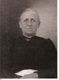
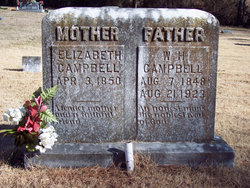
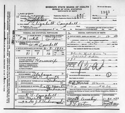
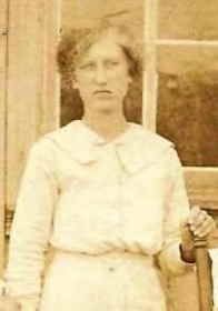
Elizabeth Myrtle “Bettie” Smith Campbell
| Birth | : | 3 Apr 1850 Dade County, Georgia, USA |
| Death | : | 19 Jan 1932 Myrtle, Oregon County, Missouri, USA |
| Burial | : | Myrtle Cemetery, Myrtle, Oregon County, USA |
| Coordinate | : | 36.5133900, -91.2664300 |
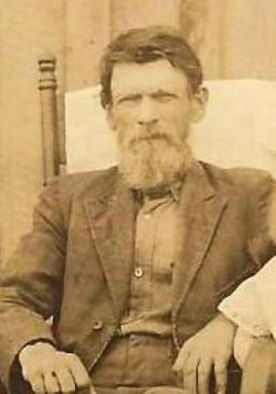
| Description | : | Missouri death certificate 1943 with R. T. Campbell of Myrtle, Oregon County, Missouri as informant. Elizabeth was daughter of George Washington Smith and Catherine Katty Martin. She married William Henry Campbell. |
frequently asked questions (FAQ):
-
Where is Elizabeth Myrtle “Bettie” Smith Campbell's memorial?
Elizabeth Myrtle “Bettie” Smith Campbell's memorial is located at: Myrtle Cemetery, Myrtle, Oregon County, USA.
-
When did Elizabeth Myrtle “Bettie” Smith Campbell death?
Elizabeth Myrtle “Bettie” Smith Campbell death on 19 Jan 1932 in Myrtle, Oregon County, Missouri, USA
-
Where are the coordinates of the Elizabeth Myrtle “Bettie” Smith Campbell's memorial?
Latitude: 36.5133900
Longitude: -91.2664300
Family Members:
Parent
Spouse
Siblings
Children


Nearby Cemetories:
1. Myrtle Cemetery
Myrtle, Oregon County, USA
Coordinate: 36.5133900, -91.2664300
2. Church of God Cemetery
Oregon County, USA
Coordinate: 36.5023500, -91.2580200
3. Byrd Cemetery
Myrtle, Oregon County, USA
Coordinate: 36.5186005, -91.3143997
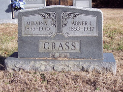
4. Crass Homestead
Myrtle, Oregon County, USA
Coordinate: 36.5359695, -91.3084671
5. Old Elmore Thomas field
Billmore, Oregon County, USA
Coordinate: 36.5237770, -91.1980250
6. Spring Valley Cemetery
Billmore, Oregon County, USA
Coordinate: 36.5324670, -91.2003420
7. Guiteau-Risner Cemetery
Guiteau, Oregon County, USA
Coordinate: 36.5588074, -91.3156128
8. Walnut Grove Cemetery
Elm Store, Randolph County, USA
Coordinate: 36.4914017, -91.1967010
9. O'Neal
Billmore, Oregon County, USA
Coordinate: 36.5712170, -91.2415410
10. Cotton Creek Cemetery
Jobe, Oregon County, USA
Coordinate: 36.5844002, -91.2652969
11. John Brown Cemetery
Jobe, Oregon County, USA
Coordinate: 36.5812111, -91.2953568
12. James Cemetery
Randolph County, USA
Coordinate: 36.4660988, -91.3435974
13. Old Jobe Cemetery
Jobe, Oregon County, USA
Coordinate: 36.5917015, -91.2517014
14. Mount Carmel Cemetery
Calm, Oregon County, USA
Coordinate: 36.5106010, -91.1643982
15. Taylor Cemetery
Ravenden Springs, Randolph County, USA
Coordinate: 36.4468994, -91.3293991
16. Garfield Cemetery
Garfield, Oregon County, USA
Coordinate: 36.5844400, -91.3253400
17. Mosely Cemetery
Randolph County, USA
Coordinate: 36.4460983, -91.1975021
18. Davis Cemetery
Sharp County, USA
Coordinate: 36.4606018, -91.3574982
19. Reynolds Cemetery
Elm Store, Randolph County, USA
Coordinate: 36.4491997, -91.1860962
20. Pigman Mound Archeological Site
Calm, Oregon County, USA
Coordinate: 36.5717100, -91.1784800
21. Stubblefield Cemetery
Dalton, Randolph County, USA
Coordinate: 36.4597015, -91.1718979
22. Bellah Cemetery
Ravenden Springs, Randolph County, USA
Coordinate: 36.4207993, -91.2825012
23. Arytown Cemetery
Arytown, Oregon County, USA
Coordinate: 36.5539513, -91.3795776
24. Liberty Cemetery
Calm, Oregon County, USA
Coordinate: 36.5586500, -91.1549600