
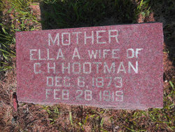

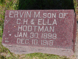
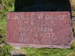
Ella Amanda “Manda” Maxwell Hootman
| Birth | : | 6 Dec 1873 |
| Death | : | 28 Feb 1919 |
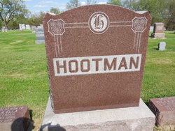
| Burial | : | Maple Hill Cemetery, Birmingham, Van Buren County, USA |
| Coordinate | : | 40.8778020, -91.9354496 |
| Plot | : | Section 5 Row 12 |
| Description | : | Note: this memorial updated December 10, 2016 with addition of "Amanda" for middle name and "Manda" for nickname, per edit request. --------------- Wife of Chester H. Hootman. |
frequently asked questions (FAQ):
-
Where is Ella Amanda “Manda” Maxwell Hootman's memorial?
Ella Amanda “Manda” Maxwell Hootman's memorial is located at: Maple Hill Cemetery, Birmingham, Van Buren County, USA.
-
When did Ella Amanda “Manda” Maxwell Hootman death?
Ella Amanda “Manda” Maxwell Hootman death on 28 Feb 1919 in
-
Where are the coordinates of the Ella Amanda “Manda” Maxwell Hootman's memorial?
Latitude: 40.8778020
Longitude: -91.9354496
Family Members:
Spouse
Children

Flowers:


Nearby Cemetories:
1. Maple Hill Cemetery
Birmingham, Van Buren County, USA
Coordinate: 40.8778020, -91.9354496
2. Methodist Episcopal Cemetery
Birmingham, Van Buren County, USA
Coordinate: 40.8788000, -91.9427000
3. United Presbyterian Cemetery
Birmingham, Van Buren County, USA
Coordinate: 40.8796000, -91.9438000
4. Parkerville Cemetery
Birmingham, Van Buren County, USA
Coordinate: 40.8666920, -91.9001710
5. Smith Cemetery
Birmingham, Van Buren County, USA
Coordinate: 40.8807983, -91.8964005
6. Clinkinbeard Family Cemetery
Libertyville, Jefferson County, USA
Coordinate: 40.9083300, -91.9583300
7. Winchester Cemetery
Winchester, Van Buren County, USA
Coordinate: 40.8499985, -91.9047012
8. Topping Cemetery
Stockport, Van Buren County, USA
Coordinate: 40.8500000, -91.8879670
9. Thompson Cemetery
Jefferson County, USA
Coordinate: 40.9155998, -91.9772034
10. Bethel Cemetery
Birmingham, Van Buren County, USA
Coordinate: 40.8967018, -92.0056000
11. Cumberland Cemetery
Jefferson County, USA
Coordinate: 40.9248000, -91.9903000
12. Pattison Cemetery
Fairfield, Jefferson County, USA
Coordinate: 40.9444008, -91.9049988
13. Fordyce Cemetery
Stockport, Van Buren County, USA
Coordinate: 40.8388000, -91.8556000
14. White Chapel Cemetery
Birmingham, Van Buren County, USA
Coordinate: 40.8417015, -92.0203018
15. Wiley Pioneer Cemetery
Jefferson County, USA
Coordinate: 40.9087000, -91.8457000
16. Kilbourne Cemetery
Van Buren County, USA
Coordinate: 40.8045000, -91.9705000
17. Jefferson County Poor Farm Cemetery
Libertyville, Jefferson County, USA
Coordinate: 40.9416900, -91.9996200
18. Miller Chapel Cemetery
Mount Zion, Van Buren County, USA
Coordinate: 40.8045000, -91.8905000
19. Roth Cemetery
Fairfield, Jefferson County, USA
Coordinate: 40.9589005, -91.9574966
20. Wilson Family Cemetery
Van Buren County, USA
Coordinate: 40.7951500, -91.9681000
21. Wright Cemetery
Fairfield, Jefferson County, USA
Coordinate: 40.9524000, -91.8728000
22. Gilbert Cemetery
Kilbourn, Van Buren County, USA
Coordinate: 40.7916926, -91.9779510
23. Rogers Cemetery
Mount Zion, Van Buren County, USA
Coordinate: 40.7916800, -91.8890600
24. Trumbo Cemetery
Stockport, Van Buren County, USA
Coordinate: 40.8166943, -91.8418354