
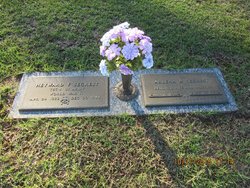
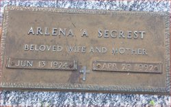
Elma Arlena Argoe Segrest
| Birth | : | 13 Jun 1924 Orangeburg County, South Carolina, USA |
| Death | : | 29 Apr 1992 Orangeburg, Orangeburg County, South Carolina, USA |
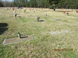
| Burial | : | Hillview Cemetery, Woodstock, Oxford County Municipality, Canada |
| Coordinate | : | 43.1206703, -80.7675400 |
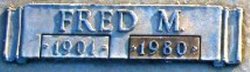
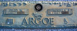
| Description | : | Mrs. Arlene Argoe Segrest, 67, of 321 Park Street, NW, Orangeburg, died Wednesday at her residence. The funeral will be held at 3 p.m. Friday at Dukes-Harley Funeral Home Chapel in Orangeburg, with the Rev. Dr. Donald F. Reams and the Rev. Howard Knowles officiating. Burial will be in Crestlawn Memorial Gardens. Mrs. Segrest was born in Orangeburg County, a daughter of the late Fred Argoe and Drucilla Judy Argoe. She was graduated from Norway High School and Palmer Business College in Charleston. She attended the Citadel and was retired from the administration department of Palmetto Baking Company. Mrs. Segrest... Read More |
frequently asked questions (FAQ):
-
Where is Elma Arlena Argoe Segrest's memorial?
Elma Arlena Argoe Segrest's memorial is located at: Hillview Cemetery, Woodstock, Oxford County Municipality, Canada.
-
When did Elma Arlena Argoe Segrest death?
Elma Arlena Argoe Segrest death on 29 Apr 1992 in Orangeburg, Orangeburg County, South Carolina, USA
-
Where are the coordinates of the Elma Arlena Argoe Segrest's memorial?
Latitude: 43.1206703
Longitude: -80.7675400
Family Members:
Parent
Spouse

Siblings

Flowers:


Nearby Cemetories:
1. Hillview Cemetery
Woodstock, Oxford County Municipality, Canada
Coordinate: 43.1206703, -80.7675400
2. Old St. Paul's Anglican Cemetery
Woodstock, Oxford County Municipality, Canada
Coordinate: 43.1325600, -80.7462300
3. Woodstock Presbyterian Cemetery
Woodstock, Oxford County Municipality, Canada
Coordinate: 43.1409440, -80.7651600
4. Woodstock Baptist Cemetery
Woodstock, Oxford County Municipality, Canada
Coordinate: 43.1416460, -80.7655790
5. Anglican Cemetery
Woodstock, Oxford County Municipality, Canada
Coordinate: 43.1426000, -80.7653300
6. Saint Marys Roman Catholic Cemetery
Woodstock, Oxford County Municipality, Canada
Coordinate: 43.1089400, -80.7998900
7. House of Refuge Cemetery
Woodstock, Oxford County Municipality, Canada
Coordinate: 43.1476245, -80.7873872
8. Oxford Memorial Park Cemetery
Woodstock, Oxford County Municipality, Canada
Coordinate: 43.1148200, -80.8150400
9. Sweaburg Union Cemetery
Sweaburg, Oxford County Municipality, Canada
Coordinate: 43.0690800, -80.7623200
10. Beachville Cemetery
Beachville, Oxford County Municipality, Canada
Coordinate: 43.0889511, -80.8313599
11. Pleasant View Cemetery
Curries, Oxford County Municipality, Canada
Coordinate: 43.0716390, -80.7196470
12. Oxford Centre Christ Church Anglican Cemetery
Oxford Centre, Oxford County Municipality, Canada
Coordinate: 43.0996310, -80.6814490
13. East Oxford Pioneer Cemetery
Oxford Centre, Oxford County Municipality, Canada
Coordinate: 43.0999370, -80.6804350
14. Old Log Church Cemetery
Embro, Oxford County Municipality, Canada
Coordinate: 43.1529121, -80.8626785
15. Huntingford Christ Church Anglican Cemetery
Huntingford, Oxford County Municipality, Canada
Coordinate: 43.2000280, -80.7960970
16. Saint Johns Anglican Cemetery
Eastwood, Oxford County Municipality, Canada
Coordinate: 43.1443080, -80.6575850
17. Vandecar Cemetery
Vandecar, Oxford County Municipality, Canada
Coordinate: 43.2010640, -80.8148020
18. West Oxford United Church Cemetery
Centreville, Oxford County Municipality, Canada
Coordinate: 43.0521710, -80.8451320
19. Methodist Cemetery
Embro, Oxford County Municipality, Canada
Coordinate: 43.1495018, -80.8983841
20. Innerkip Cemetery
Innerkip, Oxford County Municipality, Canada
Coordinate: 43.2050000, -80.6929000
21. Ingersoll Rural Cemetery
Ingersoll, Oxford County Municipality, Canada
Coordinate: 43.0545040, -80.8732690
22. Zion Oriel Cemetery
Oriel, Oxford County Municipality, Canada
Coordinate: 43.0650630, -80.6425670
23. North Embro Cemetery
Embro, Oxford County Municipality, Canada
Coordinate: 43.1667920, -80.9040350
24. Sacred Heart Cemetery
Ingersoll, Oxford County Municipality, Canada
Coordinate: 43.0514300, -80.8917200