

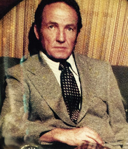
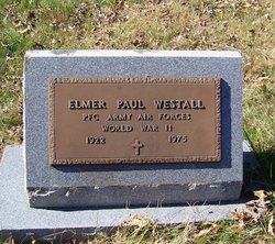
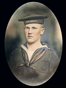
Elmer Paul “Spike” Westall
| Birth | : | 1922 |
| Death | : | 1975 |
| Burial | : | Grand Cane Cemetery, Grand Cane, DeSoto Parish, USA |
| Coordinate | : | 32.0756836, -93.7997665 |
| Description | : | PFC ARMY AIR FORCES WORLD WAR II "Uncle Elmer's pet name was Spike because of the way he styled his hair.) Message from Briana" |
frequently asked questions (FAQ):
-
Where is Elmer Paul “Spike” Westall's memorial?
Elmer Paul “Spike” Westall's memorial is located at: Grand Cane Cemetery, Grand Cane, DeSoto Parish, USA.
-
When did Elmer Paul “Spike” Westall death?
Elmer Paul “Spike” Westall death on 1975 in
-
Where are the coordinates of the Elmer Paul “Spike” Westall's memorial?
Latitude: 32.0756836
Longitude: -93.7997665
Family Members:
Parent
Spouse
Siblings
Flowers:


Nearby Cemetories:
1. Grand Cane Cemetery
Grand Cane, DeSoto Parish, USA
Coordinate: 32.0756836, -93.7997665
2. Mary Evergreen Baptist Church Cemetery
Grand Cane, DeSoto Parish, USA
Coordinate: 32.0644000, -93.7782500
3. Zion Hill Cemetery
Grand Cane, DeSoto Parish, USA
Coordinate: 32.0962000, -93.7731000
4. Friendship Cemetery
Grand Cane, DeSoto Parish, USA
Coordinate: 32.0503006, -93.8244019
5. Friendship Baptist Church Cemetery
Grand Cane, DeSoto Parish, USA
Coordinate: 32.0427800, -93.8180600
6. Old Zion Baptist Church Cemetery
Grand Cane, DeSoto Parish, USA
Coordinate: 32.0849000, -93.8415000
7. Frazier Cemetery
Mansfield, DeSoto Parish, USA
Coordinate: 32.0263420, -93.7532900
8. Hazelwood Cemetery
Grand Cane, DeSoto Parish, USA
Coordinate: 32.1403000, -93.7869000
9. Cook Cemetery
Grand Cane, DeSoto Parish, USA
Coordinate: 32.0127983, -93.8242035
10. Saint Elizabeth Cemetery
Grand Cane, DeSoto Parish, USA
Coordinate: 32.1035000, -93.7222000
11. New Bethlehem Cemetery
Grand Cane, DeSoto Parish, USA
Coordinate: 32.1501300, -93.7977200
12. Smyrna Cemetery
Grand Cane, DeSoto Parish, USA
Coordinate: 32.0917400, -93.8884700
13. Morning Glory Baptist Church Cemetery
Mansfield, DeSoto Parish, USA
Coordinate: 31.9988900, -93.7733300
14. Union Cemetery
Longstreet, DeSoto Parish, USA
Coordinate: 32.0808000, -93.8942000
15. Gamble Cemetery
Keatchie, DeSoto Parish, USA
Coordinate: 32.1218000, -93.8795000
16. Mansfield Cemetery
Mansfield, DeSoto Parish, USA
Coordinate: 32.0406000, -93.7058000
17. Flower Hill Cemetery
Keatchie, DeSoto Parish, USA
Coordinate: 32.1343994, -93.8756027
18. Henry Coleman Thweatt Burial Site
Mansfield, DeSoto Parish, USA
Coordinate: 32.0366430, -93.7064750
19. Wood Springs Baptist Church Cemetery
Logansport, DeSoto Parish, USA
Coordinate: 32.0647000, -93.9056800
20. Moore's Chapel Cemetery
Mansfield, DeSoto Parish, USA
Coordinate: 32.0125000, -93.7205000
21. New Morning Glory Baptist Temple Church Cemetery
Mansfield, DeSoto Parish, USA
Coordinate: 31.9856100, -93.7637600
22. First Community Church Cemetery
Mansfield, DeSoto Parish, USA
Coordinate: 32.0151200, -93.7127000
23. Union Cemetery
Mansfield, DeSoto Parish, USA
Coordinate: 32.0337000, -93.6971400
24. Benevolent Cemetery
Mansfield, DeSoto Parish, USA
Coordinate: 32.0274000, -93.7002000