
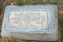
Elsie Grace Schroeder Haas
| Birth | : | 11 Aug 1897 Holstein, Adams County, Nebraska, USA |
| Death | : | 28 Jan 1980 Sterling, Logan County, Colorado, USA |
| Burial | : | St Thomas à Becket's Church, Widcombe, Bath and North East Somerset Unitary Authority, England |
| Coordinate | : | 51.3734250, -2.3465560 |
| Description | : | Funeral services for Mrs Elsie Grace Haas, 82, of 418 Taylor will be conducted 2 p.m. Thursday from the Chaney-Walters Funeral Home, Rev Harold Kaestner officiating. Burial will follow in Riverside cemetery. Mrs Haas died Tuesday in a Sterling hospital She was born Aug 11, 1897 in Holstein, Neb., the daughter of August and Ella Heuck Schroeder and moved to Kimball, Neb., with her family in 1909. The family moved to Haxtun in 1910 and thence to a homestead eight miles north of Sterling 1912. She married Charles... Read More |
frequently asked questions (FAQ):
-
Where is Elsie Grace Schroeder Haas's memorial?
Elsie Grace Schroeder Haas's memorial is located at: St Thomas à Becket's Church, Widcombe, Bath and North East Somerset Unitary Authority, England.
-
When did Elsie Grace Schroeder Haas death?
Elsie Grace Schroeder Haas death on 28 Jan 1980 in Sterling, Logan County, Colorado, USA
-
Where are the coordinates of the Elsie Grace Schroeder Haas's memorial?
Latitude: 51.3734250
Longitude: -2.3465560
Family Members:
Parent
Spouse
Siblings

Flowers:


Nearby Cemetories:
1. St Thomas à Becket's Church
Widcombe, Bath and North East Somerset Unitary Authority, England
Coordinate: 51.3734250, -2.3465560
2. Quaker Burial Ground
Widcombe, Bath and North East Somerset Unitary Authority, England
Coordinate: 51.3744350, -2.3498460
3. Bath Abbey Cemetery
Widcombe, Bath and North East Somerset Unitary Authority, England
Coordinate: 51.3712850, -2.3483060
4. Smallcombe Vale Cemetery
Bathwick, Bath and North East Somerset Unitary Authority, England
Coordinate: 51.3757400, -2.3429400
5. St John the Evangelist Cemetery
Bath, Bath and North East Somerset Unitary Authority, England
Coordinate: 51.3696700, -2.3487400
6. St. Mary The Virgin Churchyard
Bathwick, Bath and North East Somerset Unitary Authority, England
Coordinate: 51.3759930, -2.3411930
7. Old Baptist Burial Ground
Walcot, Bath and North East Somerset Unitary Authority, England
Coordinate: 51.3755070, -2.3544360
8. Abbey & St James' Graveyard for the Poor
Widcombe, Bath and North East Somerset Unitary Authority, England
Coordinate: 51.3753550, -2.3545640
9. Unitarian Chapel Burial Ground
Widcombe, Bath and North East Somerset Unitary Authority, England
Coordinate: 51.3704650, -2.3539270
10. Baptist Burial Ground
Widcombe, Bath and North East Somerset Unitary Authority, England
Coordinate: 51.3764216, -2.3556947
11. Saint Mark's Churchyard
Widcombe, Bath and North East Somerset Unitary Authority, England
Coordinate: 51.3766660, -2.3588010
12. Prior Park College
Bath, Bath and North East Somerset Unitary Authority, England
Coordinate: 51.3645990, -2.3442400
13. Old Orchard Street Catholic Burial Vault
Bath, Bath and North East Somerset Unitary Authority, England
Coordinate: 51.3800370, -2.3579910
14. St James Old Burial Ground
Bath, Bath and North East Somerset Unitary Authority, England
Coordinate: 51.3798600, -2.3610100
15. Bath Abbey
Bath, Bath and North East Somerset Unitary Authority, England
Coordinate: 51.3815310, -2.3586640
16. St Mary Magdalen Chapel
Widcombe, Bath and North East Somerset Unitary Authority, England
Coordinate: 51.3760486, -2.3643405
17. St. Mary de Stall Churchyard (Defunct)
Bath, Bath and North East Somerset Unitary Authority, England
Coordinate: 51.3813350, -2.3600353
18. Quaker Meeting House
Bath, Bath and North East Somerset Unitary Authority, England
Coordinate: 51.3823280, -2.3604380
19. Bath General Hospital Burial Ground
Bath and North East Somerset Unitary Authority, England
Coordinate: 51.3824715, -2.3614742
20. Ss Michael & Paul Churchyard
Bath, Bath and North East Somerset Unitary Authority, England
Coordinate: 51.3834970, -2.3596980
21. St. Michael's Burial Ground
Bath, Bath and North East Somerset Unitary Authority, England
Coordinate: 51.3838810, -2.3594090
22. Union Chapel
Combe Down, Bath and North East Somerset Unitary Authority, England
Coordinate: 51.3594751, -2.3443662
23. Jewish Burial Ground
Combe Down, Bath and North East Somerset Unitary Authority, England
Coordinate: 51.3599170, -2.3534670
24. St Mary's Chapel, Queens Square
Bath, Bath and North East Somerset Unitary Authority, England
Coordinate: 51.3827790, -2.3649790