
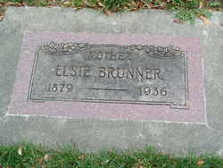
Elsie Schwotzer Brunner
| Birth | : | 13 May 1879 New Hampshire, USA |
| Death | : | 11 Jul 1936 Wenatchee, Chelan County, Washington, USA |
| Burial | : | Black Hills National Cemetery, Sturgis, Meade County, USA |
| Coordinate | : | 44.3689003, -103.4753036 |
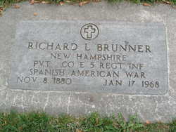
| Description | : | daughter of Wilhelm Ernst Schwotzer (1858-1907) and Emma Reisman (1857-1887) New Hampshire, Marriage Records Index, 1637-1947 Name:Richard Louis Brunner Marriage Date:11 Jul 1906 Event Type:Marriage Marriage Place:Manchester, New Hampshire Birth Date:abt 1881 Age:25 Gender:Male Father's Name:Louis Mother's Name:Fanny Barnard Spouse Name:Elsie Schwotzer Spouse Age:26 Spouse Gender:Female Spouse Father's Name:Ernest Spouse Mother's Name:Emma Reisman FHL Film Number:2057686 Washington Death Certificate name: Elsie Brunner death date: 30 Jan 1936 death place: Wenatchee, Chelan, Washington gender: Female age at death: 56 years 1 month 28 days estimated birth year: 1880 marital status: Married spouse's name:Richard L. Brunner father's name:Ernest H. Swotzer mother's name:Emma Schultz siblings: Anna Schwotzer Sinclair, Freda Schwotzer Watson children: Ellena L Brunner b: 1907, Arthur R Brunner b: 1908, Dora Louise... Read More |
frequently asked questions (FAQ):
-
Where is Elsie Schwotzer Brunner's memorial?
Elsie Schwotzer Brunner's memorial is located at: Black Hills National Cemetery, Sturgis, Meade County, USA.
-
When did Elsie Schwotzer Brunner death?
Elsie Schwotzer Brunner death on 11 Jul 1936 in Wenatchee, Chelan County, Washington, USA
-
Where are the coordinates of the Elsie Schwotzer Brunner's memorial?
Latitude: 44.3689003
Longitude: -103.4753036
Family Members:
Spouse
Children
Flowers:


Nearby Cemetories:
1. Black Hills National Cemetery
Sturgis, Meade County, USA
Coordinate: 44.3689003, -103.4753036
2. Curley Grimes Memorial Cemetery
Sturgis, Meade County, USA
Coordinate: 44.3764500, -103.4691300
3. Fort Meade National Cemetery
Sturgis, Meade County, USA
Coordinate: 44.4021988, -103.4757996
4. Bear Butte Cemetery
Sturgis, Meade County, USA
Coordinate: 44.4111595, -103.4947968
5. Saint Aloysius Cemetery
Sturgis, Meade County, USA
Coordinate: 44.4141340, -103.5193420
6. Pleasant Valley Cemetery
Tilford, Meade County, USA
Coordinate: 44.3192500, -103.3531160
7. Galena Cemetery
Galena, Lawrence County, USA
Coordinate: 44.3349220, -103.6438410
8. Crook City Cemetery
Crook City, Lawrence County, USA
Coordinate: 44.4432100, -103.6241500
9. Piedmont Cemetery
Piedmont, Meade County, USA
Coordinate: 44.2425780, -103.3871730
10. Oak Ridge Cemetery
Deadwood, Lawrence County, USA
Coordinate: 44.3891983, -103.6766968
11. Whitewood Cemetery
Whitewood, Lawrence County, USA
Coordinate: 44.4617820, -103.6330030
12. Roubaix Cemetery
Roubaix, Lawrence County, USA
Coordinate: 44.2789380, -103.6656600
13. Mount Moriah Cemetery
Deadwood, Lawrence County, USA
Coordinate: 44.3760986, -103.7253036
14. Saint Ambrose Cemetery
Deadwood, Lawrence County, USA
Coordinate: 44.3821983, -103.7266998
15. Nemo Cemetery
Nemo, Lawrence County, USA
Coordinate: 44.1872800, -103.5066410
16. Anderson Cemetery
Lawrence County, USA
Coordinate: 44.4747009, -103.6896973
17. South Lead Cemetery
Lead, Lawrence County, USA
Coordinate: 44.3478510, -103.7606260
18. Little Dane Cemetery
Saint Onge, Lawrence County, USA
Coordinate: 44.5252500, -103.6705540
19. Mountain Meadow Cemetery
Lawrence County, USA
Coordinate: 44.2038994, -103.6557999
20. West Lead Cemetery
Lead, Lawrence County, USA
Coordinate: 44.3484001, -103.7779999
21. Gate of Heaven Cemetery
Saint Onge, Lawrence County, USA
Coordinate: 44.5353000, -103.7237000
22. Terry Cemetery
Terry, Lawrence County, USA
Coordinate: 44.3344290, -103.8165110
23. Vale Cemetery
Vale, Butte County, USA
Coordinate: 44.6138992, -103.4052963
24. Holy Cross Cemetery
Englewood, Lawrence County, USA
Coordinate: 44.2818985, -103.8047028