
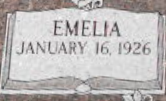
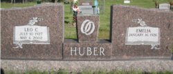
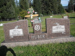
Emelia Entzel Huber
| Birth | : | 16 Jan 1926 Halliday, Dunn County, North Dakota, USA |
| Death | : | 29 Jan 2009 Corvallis, Benton County, Oregon, USA |
| Burial | : | Makaraka Cemetery, Gisborne, Gisborne District, New Zealand |
| Coordinate | : | -38.6482600, 177.9803200 |
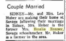
| Description | : | Emelia Huber Posted: Tuesday, Feb 03, 2009 - 03:15:00 pm MST Emelia Huber, 83, a longtime Libby resident, died Thursday, Jan. 29, 2009 in Corvallis, Ore., from natural causes. She was born Jan. 16, 1926 in Halliday, N.D. to Adolf and Lydia Entzel. She grew up and attended school in Halliday, graduating with the class of 1944. After receiving a provisional teaching license, she obtained her first teaching assignment at age 17. She attended college in Dickenson, N.D. working toward a teaching degree. She eventually earned bachelor's and master's degrees in education from the University of Montana while raising five children, teaching and farming.... Read More |
frequently asked questions (FAQ):
-
Where is Emelia Entzel Huber's memorial?
Emelia Entzel Huber's memorial is located at: Makaraka Cemetery, Gisborne, Gisborne District, New Zealand.
-
When did Emelia Entzel Huber death?
Emelia Entzel Huber death on 29 Jan 2009 in Corvallis, Benton County, Oregon, USA
-
Where are the coordinates of the Emelia Entzel Huber's memorial?
Latitude: -38.6482600
Longitude: 177.9803200
Family Members:
Parent

Spouse
Siblings


Nearby Cemetories:
1. Makaraka Cemetery
Gisborne, Gisborne District, New Zealand
Coordinate: -38.6482600, 177.9803200
2. Taruheru Cemetery
Gisborne, Gisborne District, New Zealand
Coordinate: -38.6428900, 177.9802300
3. Opou Tuarakena Cemetery
Manutuke, Gisborne District, New Zealand
Coordinate: -38.6744759, 177.9095277
4. Opou Station Cemetery
Manutuke, Gisborne District, New Zealand
Coordinate: -38.6779310, 177.9084450
5. Manutuke Churchyard Urupā
Manutuke, Gisborne District, New Zealand
Coordinate: -38.6815360, 177.9080180
6. Manutuke Whakato Urupā
Manutuke, Gisborne District, New Zealand
Coordinate: -38.6843390, 177.9073690
7. Waerenga a hika Urupā
Gisborne, Gisborne District, New Zealand
Coordinate: -38.5954100, 177.9263500
8. Patutahi Cemetery
Gisborne, Gisborne District, New Zealand
Coordinate: -38.6199300, 177.8955600
9. Paramanihi Waihirere Cemetery
Gisborne, Gisborne District, New Zealand
Coordinate: -38.5791250, 177.9488450
10. Wainui
Gisborne District, New Zealand
Coordinate: -38.6950000, 178.0707400
11. Ormond Cemetery
Ormond, Gisborne District, New Zealand
Coordinate: -38.5526480, 177.9279330
12. Pouawa Urupā
Whangara, Gisborne District, New Zealand
Coordinate: -38.6085500, 178.1825900
13. Whangara Urupā
Whangara, Gisborne District, New Zealand
Coordinate: -38.5716800, 178.2310400
14. Tapuae o te Rangi Urupā
Whatatutu, Gisborne District, New Zealand
Coordinate: -38.3791200, 177.8134180
15. Nuhaka North Cemetery
Morere, Wairoa District, New Zealand
Coordinate: -38.9797100, 177.7944300
16. Kohimarama Urupā
Tolaga Bay, Gisborne District, New Zealand
Coordinate: -38.3791770, 178.3007610
17. Tolaga Bay Cemetery
Tolaga Bay, Gisborne District, New Zealand
Coordinate: -38.3643370, 178.3045240
18. Tolaga Bay Urupā
Tolaga Bay, Gisborne District, New Zealand
Coordinate: -38.3629400, 178.3050080
19. Rakauroa Cemetery
Matawai, Gisborne District, New Zealand
Coordinate: -38.4358900, 177.5711400
20. Okuri Marea Urupa
Tolaga Bay, Gisborne District, New Zealand
Coordinate: -38.3055250, 178.2704340
21. Arataiha Urupā
Nuhaka, Wairoa District, New Zealand
Coordinate: -39.0201020, 177.7361770
22. Opoutama Cemetery
Mahia, Wairoa District, New Zealand
Coordinate: -39.0550780, 177.8405420
23. Manawarakau Urupā
Nuhaka, Wairoa District, New Zealand
Coordinate: -39.0371870, 177.7262650
24. Kaiuku Marae Urupā
Mahia, Wairoa District, New Zealand
Coordinate: -39.0823112, 177.9086516